Burkina Faso Flag, Capital and Country Facts
Burkina Faso is located in the West African inland between Sahel and wetter savannahs. Its flag is a horizontal red-green bicolour with a yellow star. Besides Ouagadougou as the capital, Loropéni, Tiébélé and old iron smelting sites tell of different historical centers that cannot be reduced to a single city or epoch.
Test your knowledge →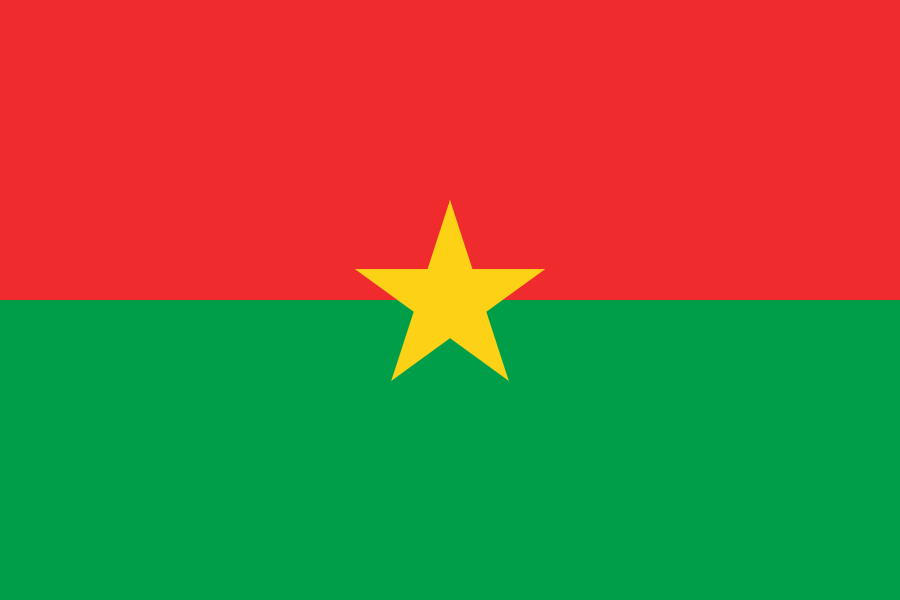
Burkina Faso at a glance
- Capital
- Ouagadougou
- Quiz continent
- Africa
- Languages in reference record
- Among others Mooré, Fulfulde, Dioula, Gourmanché and other national languages; French as an important language of communication
- Currency
- CFA-franc BCEAO (XOF)
- Population
- 24,074,580 (2025, World Bank)
- Area
- 272,967 km²
- Coastal setting
- Landlocked
- ISO codes
- BF / BFA
- Internet country suffix
- .bf
- Former State name
- Upper Volta
- Change of name
- 1984
- Highest point
- Tena Kourou, 749 m
- River system
- Volta
- Second large city centre
- Bobo-Dioulasso
- World Heritage since 2024
- King's Court of Tiébélé
Burkina Faso Flag: Design, Meaning and History
The flag consists of two horizontal fields of equal height: red above and green below. A yellow five-pointed star lies exactly in the middle and touches both color fields. There is neither an additional coat of arms nor narrow dividing lines; the clear combination of three is the most important distinguishing feature.
Red, yellow and green are part of the tradition of Pan-African flags. The current design was introduced in 1984 together with the country name Burkina Faso; previously the state was called Upper Volta. The star distinguishes the flag from a mere red-green bicolor. Political interpretations of color should be read in the context of this historical redesign.
Capital: Ouagadougou
Ouagadougou is located in the central part of the country and is its main political centre. In German, the name initially seems long; the common short form Ouaga facilitates the assignment. The location inland connects the capital with road corridors to several neighboring states, not with its own seaport.
Bobo-Dioulasso in the southwest is another important urban center. The juxtaposition of both cities helps to classify Burkina Faso spatially: capital functions are concentrated in Ouagadougou, while the southwest has its own trade and cultural traditions. Historical structures and settlements can also be found far outside the big cities, such as in the Tiébélé area.
Practise this capital →Burkina Faso: Geography, History and Culture
Wide parts of Burkina Faso consist of flat to wavy high surfaces. In the north, the savannah merges into drier Sahel landscapes; to the south, precipitation and tree population in general increase. According to the Factbook archive, the western Tena Kourou reaches 749 meters and thus forms a clear, but not a high-alpine counterpole to the extended plains. Bobo-Dioulasso is closer to the wetter southern savannah spaces.
The Mouhoun, Nakambé and Nazinon rivers are also associated with the historical names of Black, White and Red Volta. They explain the former state name Obervolta. The rivers connect the country with the Voltasystem further south. Burkina Faso borders six states and relies on transport links through neighbouring countries for access to the Atlantic.
Mooré, Fulfulde, Dioula and many other languages represent different linguistic communities. The UNESCO sites also show various forms of social organization: stone fortifications, royal court architecture and technical traditions of iron production. Those who only look at the Sahel region overlook this historical and regional wealth as well as the differences between northern and southern parts of the country.
Loropéni’
The ruins of Loropéni became a UNESCO World Heritage site in 2009. The stone fortifications are a concrete indication of historical trade and settlement networks in the southwest.
King's Court of Tiébélé
The Royal Court was added to the World Heritage List in 2024. Its recognition complements the older archaeological sites with an outstanding example of regional court architecture.
Historical iron production
The old iron smelting sites have been a World Heritage site since 2019. They draw attention to traditional technical processes and show that cultural history also includes the history of work and knowledge.
Explore neighbouring and related places
 Benin
 Côte d’Ivoire
 Ghana
 Mali
 Niger
 Togo
What did you discover?
Sources and image credits
This English article draws on the institutional sources listed below. Figures and memberships retain their stated reference dates.
Source record: 2 November 2026. A translation does not change the reference date of a figure or membership list.
- github.com/factbook/factbook.json/blob/144d6977b2b01ac1cbd220de754c0a005616760b/africa/uv.json
- data.worldbank.org/indicator/SP.POP.TOTL
- whc.unesco.org/en/statesparties/bf/
- github.com/mledoze/countries