Benin Flag, Capital and Country Facts
Benin is a narrow state between the Gulf of Guinea and the West African landlocked country. Porto-Novo is its capital, but many government tasks are concentrated in Cotonou. The history of Dahomey, the palaces of Abomey and cross-border cultural landscapes show why the country cannot be reduced to its short coastal strip.
Test your knowledge →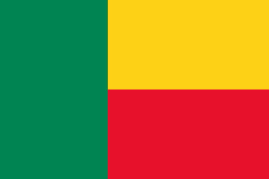
Benin at a glance
- Capital
- Porto-Novo
- Quiz continent
- Africa
- Languages in reference record
- French (official); among others Fon, Yoruba, Bariba and Fulfulde
- Currency
- West African CFA franc (XOF)
- Population
- 14,814,460 (2025, World Bank)
- Area
- 112,622 km²
- Coastal setting
- Not landlocked
- ISO codes
- BJ / BEN
- Internet country suffix
- .bj
- Headquarters
- Cotonou
- Independence
- 1 August 1960 from France
- Former State name
- Dahomey
- Name of Benin
- Since 1975
- Mountains
- Atakora
- Historical centre
- Abomey
Benin Flag: Design, Meaning and History
Porto-Novo is the capital; most government functions are based in Cotonou.
On the left is a green vertical stripe; on the right are a yellow and a red field on top of each other. All three colors are arranged without a coat of arms or star. The unusual combination of vertical and horizontal division is the most important indication to distinguish Benin from other green-yellow-red flags.
Green, yellow and red are among the pan-African colors. The Factbook archive combines green with hope and renewal, yellow with wealth and red with courage. Such assignments complement the visible design; however, the shape of the three fields is first crucial for secure recognition in the quiz.
Capital: Porto-Novo
Porto-Novo is the constitutional capital of Benin. Its Portuguese name means “new port” and commemorates the long history of European trade contacts on this coast. The naming as a capital is correct, but does not describe the spatial organization of the state alone.
Cotonou is the seat of government and at the same time an important port and business location. Anyone who confuses Porto-Novo and Cotonou therefore overlooks a real division of state functions. This coexistence distinguishes Benin from countries where the capital, largest economic metropolis and central government authorities are located in the same place.
Practise this capital →Benin: Geography, History and Culture
To the south are wet warm coastal areas, while to the north it becomes drier. The terrain consists mainly of plains and flat waved land, next to it there is the Atakora mountain landscape in the northwest. The long north-south extension thus connects different natural areas. A glance at the situation on the Atlantic Ocean alone explains the climate of the entire country only inadequately.
French serves as the official language, while Fon, Yoruba, Bariba, Fulfulde and other languages are important regionally. Language areas transcend today's borders. This is also evident in the UNESCO heritage: Koutammakou connects Benin with Togo, the W-Arly-Pendjari complex with neighboring states in the north. Political boundaries and cultural or ecological landscapes do not coincide here.
The Kingdom of Dahomey developed on the plateau of Abomey since the 17th century. Its history includes political power, art and involvement in the Atlantic trade of enslaved people. After French colonial rule, the country became independent in 1960; the name Benin bears it since 1975. Today’s Benin is not easy to equate with the historical kingdom of Benin in today’s Nigeria.
Palaces of Abomey
The Royal Palaces of Abomey were included in the UNESCO World Heritage List in 1985. They are a concrete anchor point of Dahomey’s history. Its importance therefore lies not only in individual buildings, but also in the memory of an earlier political order.
Koutammakou
The cultural landscape of the Batammariba belongs to a cross-border world heritage with Togo. The Beniner share was added in 2023. This illustrates that common building and living spaces can be older than the borders of modern states.
W-Arly-Pendjari
This natural complex is listed as a transboundary world heritage. It draws attention to savannahs and protected areas of the north. For Benin’s geographical profile, this is an important counterbalance to the much better known port cities and lagoons in the south.
Explore neighbouring and related places
 Burkina Faso
 Niger
 Nigeria
 Togo
What did you discover?
Sources and image credits
This English article draws on the institutional sources listed below. Figures and memberships retain their stated reference dates.
Source record: 2 November 2026. A translation does not change the reference date of a figure or membership list.
- github.com/factbook/factbook.json/blob/144d6977b2b01ac1cbd220de754c0a005616760b/africa/bn.json
- data.worldbank.org/indicator/SP.POP.TOTL
- whc.unesco.org/en/statesparties/bj
- github.com/mledoze/countries