Niger Flag, Capital and Country Facts
Niger lies in the interior of West Africa and extends far into the Sahara. The river of the same name only crosses the southwest of the large state territory, but shapes the location of the capital Niamey there. The flag shows orange, white and green with an orange disc. The comparison with India helps to distinguish the motif safely.
Test your knowledge →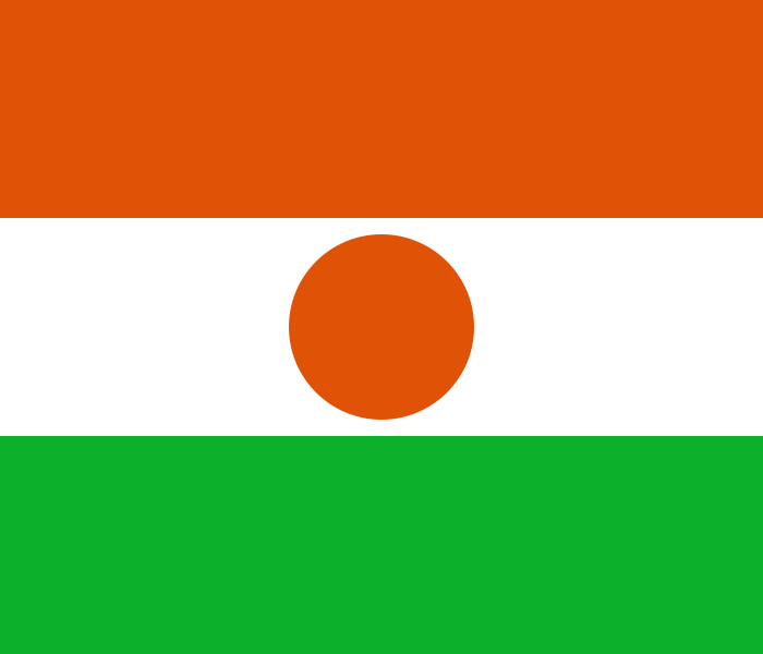
Niger at a glance
- Capital
- Niamey
- Quiz continent
- Africa
- Languages in reference record
- Hausa; also, inter alia, Zarma-Songhai, Tamascheq, Fulfulde and Kanuri; French and English as working languages
- Currency
- West African CFA franc (XOF)
- Population
- 27,917,831 (2025, World Bank)
- Area
- 1,267,000 km²
- Coastal setting
- Landlocked
- ISO codes
- NE / NER
- Internet country suffix
- .ne
- Important river
- Niger
- Mountains
- Aïr
- Desertification
- Ténérée
- Historical city
- Agadez
- Independence
- 3 August 1960
- Neighboring country in the south
- Nigeria
Niger Flag: Design, Meaning and History
Three equally wide horizontal stripes show orange above, white in the middle and green below. In the white center there is an orange disc. The sign is fully filled in and has no spokes. Although India uses a similar color structure, it shows a dark blue wheel. The color and shape of the middle sign are therefore crucial.
The factbook archive of 2025 combines orange with the Saharan landscapes of the north and green with the more fertile southern and western areas. White is associated with purity and peace, the disc with the sun. Such national interpretations symbolically summarize landscape contrasts, but do not replace an exact geographical description of the entire country.
Capital: Niamey
Niamey is located on Niger in the southwest of the country. The capital thus belongs to the space in which the great river actually touches and crosses the state border. The country bears his name, but a large part of Niger is far from this river. This distinction is particularly useful for geographical orientation.
The river’s location connects Niamey with trade, agriculture and transport routes in the region. Agadez, on the other hand, lies further north on historical Saharan routes and has a different city history. It is not the capital, but is often called because of its historical importance. The two locations illustrate different geographical and cultural focuses within the same state.
Practise this capital →Niger: Geography, History and Culture
The north is predominantly desert; in the south are Sahel landscapes with stronger seasonal precipitation. The Aïr Mountains and the Ténéré are particularly striking spaces in the Sahara. The west belongs to the Niger basin, the southeast touches the Lake Chad region. This results in a greater hydrological diversity than the term desert state initially suggests.
Hausa is an important language of the country and the wider region. Zarma-Songhai, Tamascheq, Fulfulde and Kanuri represent other linguistic spaces. The diversity points to connections between river landscapes, Sahel and Sahara. Names such as Niger and Nigeria should not be confused: they are two different states with a common border and different capitals.
The historic center of Agadez is a UNESCO cultural heritage site. The Aïr and Ténéré nature reserves as well as the W-Arly-Pendjari cross-border complex represent natural heritage. The comparison shows two different landscapes: Sahara and southwestern savannahs. A common country profile therefore needs to take more into account than dunes, and a protected area on a state border can be part of a larger international system.
Disk instead of wheel
The orange disc distinguishes Niger's flag from India. The similar stripe sequence alone is not sufficient for determination.
Agadez as a historical node
The historic center of Agadez has been on the UNESCO list since 2013. Its history is closely linked to the connections through the Sahara.
Nature across borders
W-Arly-Pendjari is a cross-border World Heritage site. The Nigerien part belongs to a larger savannah area with neighboring protected areas.
Explore neighbouring and related places
 Algeria
 Benin
 Burkina Faso
 Chad
 Libya
 Mali
What did you discover?
Sources and image credits
This English article draws on the institutional sources listed below. Figures and memberships retain their stated reference dates.
Source record: 2 November 2026. A translation does not change the reference date of a figure or membership list.
- github.com/factbook/factbook.json/blob/144d6977b2b01ac1cbd220de754c0a005616760b/africa/ng.json
- data.worldbank.org/indicator/SP.POP.TOTL
- whc.unesco.org/en/statesparties/ne
- senat.fr/questions/base/2025/qSEQ250404328.html
- github.com/mledoze/countries