Lübeck: City Flag, History and Identity
Lübeck connects a medieval old town with the access to the Baltic Sea via the Trave. The former leadership role in the Hanseatic League is still recognizable today on streets, merchants’ houses and churches. The double eagle appears on the white-red city flag: a sign of urban tradition that differs from the symbols of today's federal state of Schleswig-Holstein.
Test your knowledge →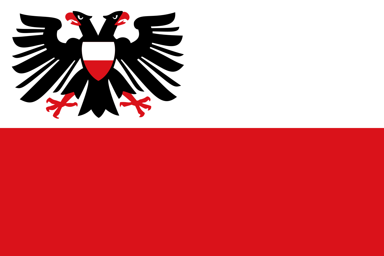
Lübeck at a glance
- Name
- Lübeck
- Country
- Germany
- Profile type
- City
- Urban river
- Trave
- Further characteristic river
- Wakenitz
- Connection with the Baltic Sea
- About Travemünde
- Year of foundation of today's town
- 1143
- Older Slavic place
- Liubice, further downstairs
- Historical City Law
- Lübische Recht
- Acquisition of Travemünde
- 1329
- World Heritage Registration
- 1987
The Flag of Lübeck
The flag is divided horizontally: white above, red below. In the upper corner on the mast stands the black Lubeck double eagle with red-white breast drawing. The eagle is not simply placed in the middle of the entire cloth. For the recognition, its position and the order of the two color paths are equally important.
The main urban statutes expressly describe this form and distinguish it from the vertical banner. The double eagle is in historical connection with Lübeck's former imperial freedom. It is not an indication that Lübeck would be an independent federal state today. The city continues its Hanseatic designation and its own symbols within Schleswig-Holstein.
Lübeck: Location and Territorial Role
Lübeck is located in the southeast of Schleswig-Holstein on the Trave. The historic old town is located on an island surrounded by water; Travemünde provides access to the Baltic Sea. The municipality therefore comprises very different spaces. The medieval city centre, harbour areas and the coast at Travemünde belong to the same city, but do not look the same in terms of landscape.
The elongated old town has main axes along its higher back and roads that lead down to the watercourses. Merchant’s houses were especially in the west; smaller trades and craftsmen shaped eastern areas. This historical division of labor helps to understand the floor plan. The city was not only a collection of representative monuments, but an organized trading and living space.
Landscape, History and Culture
Trave, Wakenitz and the Elbe-Lübeck Canal characterize the water landscape around the old town. Access to the sea was crucial for trade. With the acquisition of Travemündes in 1329, Lübeck secured an important connection to the Baltic Sea. The local history can therefore only be understood in the context of island city, river path and coastal access.
The founding year of today’s Lübeck is 1143. The older Slavic Liubice lay in another place further down the trave. Henry the Lion later supported the reconstruction and granted rights. The development of urban law gave rise to Lübische Recht, which was adopted by numerous other cities in the Baltic Sea region. As a result, Lübeck’s impact extended beyond the trade in goods.
The Hanseatic League was an association of merchants and cities that emerged over a long period of time, not a centrally governed nation state. Lübeck played a leading role in this and was often the site of the Hanseatic League. The significance was based on trade routes, privileges and cooperation. The expression Queen of the Hanseatic League describes this outstanding position figuratively and is not a royal title of office.
Holstentor and Salzspeicher
On the left bank of the Trave are the Holstentor and the historic Salzspeicher. Both belong to the spatial context of the World Heritage. The connection of the gate, river and warehouse buildings shows how the city entrance and trade interacted. The storages complement the well-known gateway by the economic function of this part of the city.
Old Town as a World Heritage Site
Parts of the old town have been a UNESCO World Heritage site since 1987. Among other things, the historical floor plan, the building substance and the city silhouette are honored. The award refers to demarcated areas; it does not mean that every current building on the entire Old Town Island has the same historical status.
Travemous
Travemünde makes Lübeck's reference to the Baltic Sea directly experienceable. From the city centre, the Trave leads to this coastal and harbour space. The difference between historical island town and maritime outskirts is particularly clear: both places belong to the Hanseatic city, but show different tasks and landscapes within a common communal area.
Explore this country and nearby profiles
 Germany
 Munich
 Cologne
 Frankfurt am Main
 Stuttgart
 Düsseldorf
 Dresden
What did you discover?
Take this flag into the quiz
Sources and image credits
This English article draws on the institutional sources listed below. Figures and memberships retain their stated reference dates.
Source record: 2 November 2026. A translation does not change the reference date of a figure or membership list.
- luebeck.de/de/bekanntmachungen/oertliche-bekanntmachungen
- luebeck.de/de/stadtleben/tourismus/luebeck/geschichte/geschichte
- luebeck.de/de/stadtleben/tourismus/luebeck/geschichte/luebecks-gruendung
- luebeck.de/de/stadtleben/tourismus/luebeck/geschichte/luebeck-als-koenigin-der-hanse
- whc.unesco.org/en/list/272
- commons.wikimedia.org/wiki/File%3AFlagge_der_Hansestadt_L%C3%BCbeck.svg