Ticino: Canton Flag, Capital and Regional Profile
Ticino connects alpine valleys with the lakes and pre-alps of Italian-speaking Switzerland. Bellinzona is its main town and preserves an impressive historical fortification landscape. The plain red-blue flag stands for a canton whose present political unity only emerged in 1803 and whose different parts long had their own historical paths and regional relations.
Test your knowledge →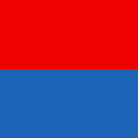
Ticino at a glance
- Name
- Ticino
- Country
- Switzerland
- Profile type
- Swiss canton
- Administrative seat in source record
- Bellinzona
- Italian cantonal name
- Ticino
- Border State
- Italy
- Large parts of the landscape
- Sopraceneri and Sottoceneri
- Great lake
- Lago Maggiore’
- Another large lake
- Lake Lugano
- End of the old land bird order
- 1798
- Cantonal Creation
- 1803
- Three UNESCO castles
- Castelgrande, Montebello and Sasso Corbaro
- Historical function of Bellinzona
- Control of valley access
The Flag of Ticino
The square flag shows two equally high horizontal color areas: red above and blue below. Neither coat of arms nor writing nor stars complement the division. The order and the quadratic format therefore determine the visible character. A white Swiss cross does not belong to the cantonal flag depicted here.
The simplicity requires an exact color comparison, because red and blue appear on many flags. For this selection, only the horizontal division is decisive. From the picture alone, no reliable narration of origin of the country colors can be derived. Equating red with a certain valley or blue with a certain lake would be unoccupied.
Ticino: Location and Territorial Role
Ticino is called Ticino in Italian. It is located south of the main Alpine ridge and has a long border with Italy. Bellinzona assumes the role of capital, while Lugano, Locarno and other centres have their own roles in the settlement structure. The entire canton is therefore not to be equated with a single sea city.
Traditionally, there is a distinction between Sopraceneri and Sottoceneri. North, more Alpine mountain areas and deeply cut valleys characterize the picture, south, the space opens towards the Po plain and has a more pronounced pre-alpine character. This structure helps to organize the strong landscape differences within the Italian-speaking canton.
Landscape, History and Culture
Lake Maggiore and Lake Lugano are the largest lakes with Ticino shares. Both extend beyond the canton and connect different shore regions. In addition, there are smaller natural lakes, alpine waters and artificial storage for electricity generation. The usual sea views therefore tell only a part of the Ticino water landscape.
The political history of today’s canton has two decisive dates: in 1798 the old land bird order ended south of the Gotthard; in 1803 the canton of Ticino was created in connection with the mediation acts. The unification of different areas was not a smooth process or one that was unanimously desired everywhere. External political developments played a significant role in its creation.
Bellinzona’s fortifications make visible the strategic importance of the valley space. Castelgrande, Montebello and Sasso Corbaro together with walls form a UNESCO ensemble. It protected the city and controlled the passage through the valley. Architectural history, trade and military spatial control can therefore be directly linked at this location.
Three Castles of Bellinzona
Castelgrande stands on a striking rock above the valley. Montebello is part of the fortification system, while Sasso Corbaro is located on its own rocky outcrop southeast of it. Their different locations show how several buildings were able to oversee and control a valley space together.
Walls as valley bars
The walls of Bellinzona were not exclusively a boundary of the urban housing. They also blocked the way through the valley. This explains why their location is so important for the understanding of world heritage: the site and the building formed a common strategic system.
From the Mountains to the Lakes
The Ticino landscape changes from high alpine spaces to deeper lake landscapes and southern pre-Alpines. Such a sequence influences traffic routes and settlements as well as the tourist image. The canton thus combines very different natural conditions, which belong together under the same simple red-blue flag.
Explore this country and nearby profiles
 Switzerland
 Zurich
 Bern
 Geneva
 Vaud
 St Gallen
 Graubünden
What did you discover?
Take this flag into the quiz
Sources and image credits
This English article draws on the institutional sources listed below. Figures and memberships retain their stated reference dates.
Source record: 2 November 2026. A translation does not change the reference date of a figure or membership list.
- m3.ti.ch/DFE/DR/USTAT/allegati/prodima/3302_territorio_e_ambiente.pdf
- www4.ti.ch/decs/dcsu/pubblicazioni/bicentenario-del-cantone-ticino/la-storia
- whc.unesco.org/en/list/884/
- m3.ti.ch/DFE/DR/USTAT/allegati/volume/ds_7_documento.pdf