St Gallen: Canton Flag, Capital and Regional Profile
The canton of St. Gallen comprises landscapes between Lake Constance, Rhine Valley, Toggenburg and alpine heights. The city of the same name is his main town, but the canton unites many more historic spaces. Its green flag with the white bundle of rods is reminiscent of the establishment of a common state and is distinctly different from the bear that is associated with the city.
Test your knowledge →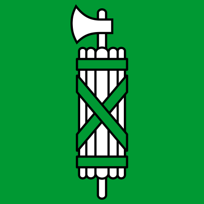
St Gallen at a glance
- Name
- St Gallen
- Country
- Switzerland
- Profile type
- Swiss canton
- Administrative seat in source record
- St. Gallen
- Establishment of the Canton
- 1803
- Co-founder
- Karl Müller-Friedberg
- Highest point
- Ringelspitz, 3,247 meters
- Deepest area
- Lake Constance
- International neighbours
- Germany, Austria and Liechtenstein
- Lakes with cantonal share
- Lake Constance, Walensee and Lake Zurich
- River in Toggenburg
- Thurs
- UNESCO sites
- County of St. Gallen
- Baroque conversion phase
- 1755–1768
The Flag of St Gallen
On the green square cloth lies a white bundle of rods with ribbons and an axe. The blade points laterally out of the bundle. A plurality of rods and the crossing bands are visible in the planar representation. The motif is not a tree or a simple white pillar.
The staffs originally stood for the eight districts of the first cantonal constitution of 1803. The ribbons symbolize cohesion, the axe common strength. When it was founded, green was considered a color of freedom. Today's two-dimensional drawing does not show all eight rods individually. The historic districts are also not the same as today's constituencies.
St Gallen: Location and Territorial Role
St. Gallen is located in eastern Switzerland and borders Germany, Austria and Liechtenstein. The canton owns shares in Bodensee, Walensee and Zürichsee. These distant shores already show that the cantonal geography is much larger and more diverse than the area of the capital of the same name.
Broad valleys are of great importance for settlement and traffic. These include Rheintal, Seeztal, Linthebene and Toggenburg. The Rhine, Seez, Linth and Thur open up these spaces as important rivers. Its valleys are also important groundwater carriers, combining landscape form, water balance and human supply.
Landscape, History and Culture
In the south, the Alps characterize the picture, in the north landscapes of the Mittelland. The Ringelspitz on the border to Graubünden is the highest point with 3,247 meters. The deepest area is on Lake Constance. Between these extremes of altitude, relief, land use and accessibility alternate, making regional differences within the canton particularly clear.
The canton was founded in 1803 and previously connected different dominions. Karl Müller-Friedberg played a key role in its founding. The common political umbrella was therefore not simply the continuation of a single older territory. The flag with the bound bundle of rods fits this task of bringing together various historical spaces into one state.
The collegiate district in the capital has a history that goes back far before the founding of the canton. The monastery was for many centuries one of the important spiritual centers of Europe. The library and cathedral characterize the UNESCO ensemble. Monastery history, city history and cantonal history are connected, but are neither temporally nor spatially completely identical.
Collegiate Library
The library preserves outstanding manuscripts, including the famous parchment-drawn monastery plan. Such documents explain the rank of the pen as a place of knowledge. The World Heritage value is therefore based on more than the visible architecture; the surviving written testimonies also contribute significantly to the understanding of the historical center.
The Baroque Ensemble
Between 1755 and 1768, the monastic area was transformed into baroque forms. The present phenomenon is thus younger than the early medieval beginnings of the monastery. This temporal stratification makes the place interesting: Old institutions, manuscripts and later forms of construction have been preserved together and complement each other.
Lakes and cantonal borders
Lake Constance, Lake Walensee and Lake Zurich are each shared with other cantons or states. The shores create connections, while the waters also touch political boundaries. The canton is therefore well known over several sea and valley spaces, instead of only describing it over the capital and its collegiate district.
Explore this country and nearby profiles
 Switzerland
 Zurich
 Bern
 Geneva
 Vaud
 Ticino
 Graubünden
What did you discover?
Take this flag into the quiz
Sources and image credits
This English article draws on the institutional sources listed below. Figures and memberships retain their stated reference dates.
Source record: 2 November 2026. A translation does not change the reference date of a figure or membership list.
- sg.ch/ueber-den-kanton-st-gallen/portraet-des-kantons-st-gallen/geschichte-und-wappen.html
- sg.ch/ueber-den-kanton-st-gallen/portraet-des-kantons-st-gallen/geografie-und-umwelt.html
- whc.unesco.org/en/list/268/
- hls-dhs-dss.ch/de/articles/007390/2017-05-11/