Schleswig-Holstein: State Flag, Capital and Regional Profile
Schleswig-Holstein is located between the North Sea and the Baltic Sea and therefore has two very different coastal worlds. Wadden Sea, Halligen, port cities and the North Sea Channel shape the image of the northernmost German federal state. Its blue-white-red flag is simple; the history of the country, on the other hand, is only revealed by the interplay of German, Danish and other regional traditions.
Test your knowledge →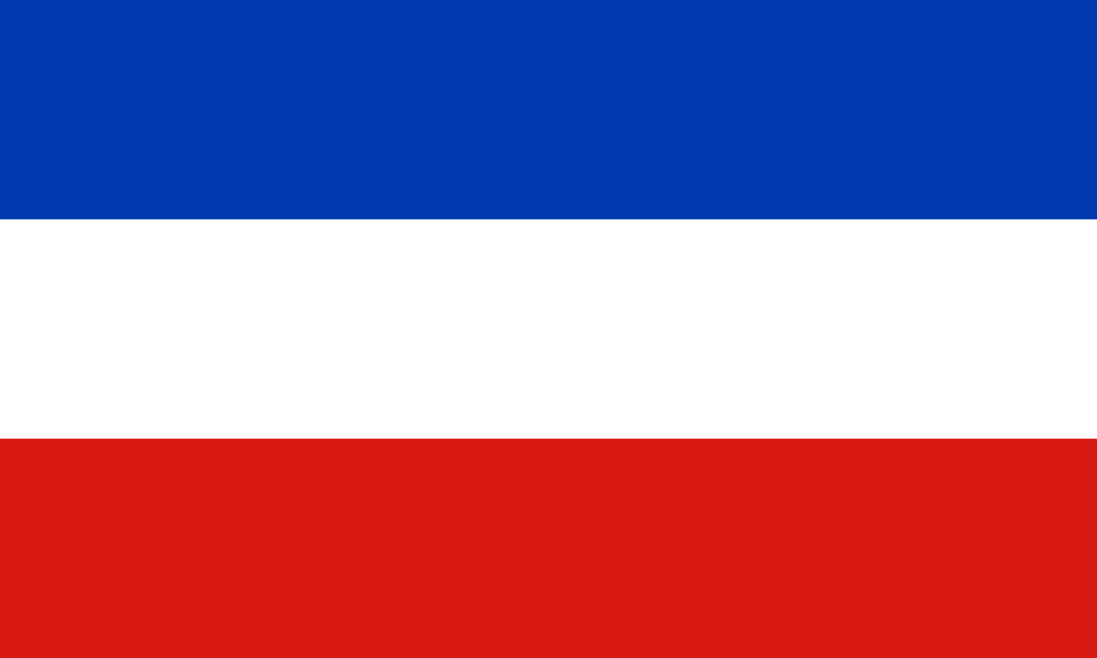
Schleswig-Holstein at a glance
- Name
- Schleswig-Holstein
- Country
- Germany
- Profile type
- German federal state
- Administrative seat in source record
- Kiel
- Western Sea
- North Sea
- Eastern Sea
- Baltic Sea
- Neighbouring Northern State
- Denmark
- Special coastal shape
- Hallows
- Large waterway
- Canal North-Baltic
- International Nature Area
- Wadden Sea
- World Heritage recognition Wadden Sea
- 2009
- Migratory bird route
- East Atlantic train route
- Maritime event
- Kiel Week
The Flag of Schleswig-Holstein
The country flag shown consists of three horizontal stripes of equal height. From top to bottom follow blue, white and red. A coat of arms or writing is not available on this variant. For a safe allocation, the sequence is therefore more important than the mere occurrence of the three common colors.
The simple tricolor should be distinguished from a service flag with a heraldic shield. The country has its own historical coat of arms traditions for Schleswig and Holstein, but they are not visible on the cloth selected here. The description includes only the elements actually shown; a coastal landscape is not depicted on the flag.
Schleswig-Holstein: Location and Territorial Role
Schleswig-Holstein extends in the north of Germany to the border with Denmark. Kiel is located on the Baltic Sea and is the state capital. The location between two seas is more than just a tourist formula: it explains coastal protection, shipping, port locations and the importance of connections across the country.
The west coast is characterized by the North Sea, Wadden and offshore islands. On the Baltic Sea you will encounter other coastal forms and harbour spaces. Inland lakes, rivers and different agricultural landscapes complement the picture. The federal state should therefore not be equated with a single beach or watt motif.
Landscape, History and Culture
The Wadden Sea is a landscape in constant motion. Ebb and flow expose and cover surfaces; sediments are rearranged and habitats change. Nature conservation also means making natural processes possible. The Schleswig-Holstein coastline forms only a part of this system, which extends to the Netherlands and Denmark.
Halligen are a special settlement and landscape form of the North Sea coast. Its location in the sphere of influence of the sea makes the relationship between human everyday life, coastal protection and natural dynamics particularly clear. They are part of the understanding of North Frisia as well as the larger islands and the dense marshes on the mainland.
German-Danish relations run through the country’s history. As a result, Schleswig-Holstein has a cultural border position that cannot be explained solely by looking at the current state border. At the same time, the Kiel Week and maritime transport routes connect the country with distant coasts, ports and international encounters.
Wadden Sea National Park
The Schleswig-Holstein Wadden Sea National Park protects an important section of the North Sea coast. It is also part of a larger international natural context. Tranquil migratory birds use the area on the East Atlantic migratory route, which gives local habitats a function far beyond national borders.
World Heritage and Biosphere Reserve
The international World Heritage recognition of the Wadden Sea took place in 2009. In addition, there are biosphere reserves and national parks with their own spatial and organizational boundaries. These terms refer to different concepts of protection and therefore their names may not be used as fully interchangeable designations of the same administrative unit.
Canal North-Baltic
The canal is one of Schleswig-Holstein’s defining maritime connections. It makes the situation of the country between two seas particularly vivid. Together with the ports, it shows that the inland and its transport routes are just as much a part of maritime history as the open coasts.
Explore this country and nearby profiles
 Germany
 Munich
 Cologne
 Frankfurt am Main
 Stuttgart
 Düsseldorf
 Dresden
What did you discover?
Take this flag into the quiz
Sources and image credits
This English article draws on the institutional sources listed below. Figures and memberships retain their stated reference dates.
Source record: 2 November 2026. A translation does not change the reference date of a figure or membership list.
- schleswig-holstein.de/DE/landesportal/land-und-leute
- nationalpark-wattenmeer.de/sh/
- unesco.de/staette/schleswig-holsteinisches-wattenmeer-und-halligen/
- schleswig-holstein.de/DE/landesregierung/themen/kueste-wasser-meer