Saxony-Anhalt: State Flag, Capital and Regional Profile
Saxony-Anhalt connects vast agricultural landscapes with the Harz, historical residences and important cultural sites on the Elbe. Today’s federal state has a comparatively young political form, while its cities and landscapes look back on many older traditions. The yellow-black flag with country coat of arms makes this connection of different historical spaces visible in a common emblem.
Test your knowledge →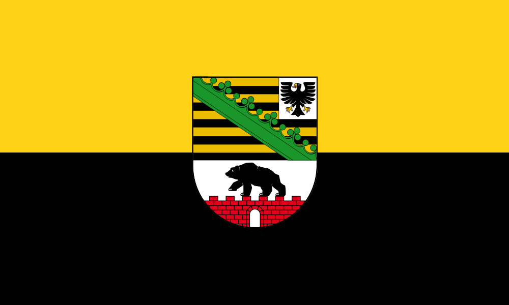
Saxony-Anhalt at a glance
- Name
- Saxony-Anhalt
- Country
- Germany
- Profile type
- German federal state
- Administrative seat in source record
- Magdeburg
- Northern Landscape
- Altmark
- Fertile agricultural landscape
- Magdeburger Börde
- Highest mountain
- Rocks in the resin
- Height of the chunk
- Around 1,141 meters
- Central flow axis
- Elbe
- First country phase
- 1947–1952
- Re-establishment
- 1990
- World Heritage of Enlightenment
- Garden Kingdom of Dessau-Wörlitz
- Foundation of the Archdiocese of Magdeburg
- 968
The Flag of Saxony-Anhalt
The flag shown has a yellow upper and a black lower stripe. There is a heraldic shield in the center. In its upper part, black-golden beams with a green diamond ring and an eagle can be seen; below, a black bear appears on a red wall.
The coat of arms connects signs of the historical landscapes of Saxony and Anhalt. Just the bear on the wall is a helpful distinguishing feature. The flag does not represent a cityscape, but condenses several heraldic traditions. The colors and shield motifs should be considered together when similar German flags are kept apart.
Saxony-Anhalt: Location and Territorial Role
Saxony-Anhalt is located in the Middle East of Germany. The state capital Magdeburg is located on the Elbe. From the Altmark in the north, the country stretches over the Magdeburger Börde and the Harzvorland to southern landscapes with hall, the Saaleraum and a dense succession of historical places.
The Elbe flows through the country from southeast to northwest and forms an important transport and landscape axis. Their floodplains are in clear contrast to the heights of the resin. Agricultural areas also have different profiles; especially the fertile black soils of the Magdeburger Börde are characteristic of the country.
Landscape, History and Culture
The Brocken is the highest mountain of Saxony-Anhalt and the Harz. The mountains continue beyond national borders to Lower Saxony and Thuringia. It therefore makes sense to understand the Harz as a natural area of its own and to distinguish its political sub-areas from it. At the edge, mountain heights change to more open forelands.
The country existed under the name Saxony-Anhalt from 1947 to 1952 and was re-established in 1990. In between, especially the districts of Halle and Magdeburg shaped the administration. The older history of the area, however, includes independent cities, spiritual dominions and Anhaltian territories that emerged well before this formation of the land.
The Garden Kingdom of Dessau-Wörlitz stands for a landscape design of the Enlightenment. Parks, buildings and agricultural land form a conscious connection there. Beauty should be associated with education and practical improvement. This idea extends the usual view of a castle: visual axes, paths and usable areas are also part of the historical statement.
Garden Kingdom of Dessau-Wörlitz
Leopold III Friedrich Franz von Anhalt-Dessau and the architect Friedrich Wilhelm von Erdmannsdorff shaped the garden kingdom. Suggestions from England and Italy flowed into an independent cultural landscape. The UNESCO entry pays tribute to the interplay between architecture, landscape and educational goals.
Magdeburg and Otto I.
Otto I promoted Magdeburg as the center of his rule. In 968 the Archdiocese was founded, and after his death in 973 Otto was buried in Magdeburg Cathedral. This connection explains why the city plays a prominent role in depictions of medieval imperial history.
Magdeburger Börde
The river is known for its particularly fertile black soils. In doing so, it offers an important key to the country’s agricultural history. Its open landscape character differs significantly from the forested mountain locations of the Harz or the natural flooding areas along the Elbe.
Explore this country and nearby profiles
 Germany
 Munich
 Cologne
 Frankfurt am Main
 Stuttgart
 Düsseldorf
 Dresden
What did you discover?
Take this flag into the quiz
Sources and image credits
This English article draws on the institutional sources listed below. Figures and memberships retain their stated reference dates.
Source record: 2 November 2026. A translation does not change the reference date of a figure or membership list.
- sachsen-anhalt.de/land-sachsenanhalt/land-und-leute/page/geschichte
- sachsen-anhalt.de/land-sachsenanhalt/land-und-leute/page/das-land-sachsenanhalt-kurz-und-knapp
- whc.unesco.org/en/list/534/