Saarland: State Flag, Capital and Regional Profile
Saarland connects German history with a narrow neighbourhood in France and Luxembourg. Its eponymous Saar, the industrial landscapes around Saarbrücken and the wooded heights tell different stories of the same small federal state. The flag links the German colors with a coat of arms that brings together older gentlemen in today's territory and thus makes the historical complexity visible.
Test your knowledge →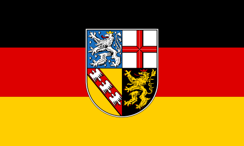
Saarland at a glance
- Name
- Saarland
- Country
- Germany
- Profile type
- German federal state
- Administrative seat in source record
- Saarbrücken
- Name-giving river
- Saar
- Neighbouring countries
- France and Luxembourg,
- Political connection
- 1 January 1957
- Economic Connection
- 1959
- World Heritage Site
- Völklinger Hütte
- World Heritage Site of the hut
- 1994
- Decommissioning of the old hut
- 1986
- First Mention of People
- 822
The Flag of Saarland
The flag shown bears three horizontal stripes in black, red and gold. In its center stands the national coat of arms, which extends beyond the strip boundaries. Unlike a pure German flag, it thus has a clear regional identification mark: a shield with several different coat of arms fields.
The quartered coat of arms is reminiscent of historical territories that dominated parts of today's Saarland. Among other things, lions can be seen as well as a red cross and a red oblique beam with silver eagles. The combination of these signs makes it clear that today's national borders do not represent an unchanged medieval rule.
Saarland: Location and Territorial Role
The Saarland is located in the southwest of Germany between Rhineland-Palatinate, France and Luxembourg. Saarbrücken is the political centre. The cross-border context is just as important in everyday life as the classification in Germany: transport routes, industrial relations and cultural contacts do not end here at a linguistic or state border.
The Saar forms an important spatial axis on which cities, former mines and hut sites developed. Saarbrücken and Völklingen are particularly vivid examples of how closely connected river basin space, industry and urban growth were. The countryside also includes villages, forests and hilly landscapes with a different settlement rhythm.
Landscape, History and Culture
Industrialization profoundly changed the Saar region. Coal and iron created jobs and new settlements; mechanical engineering, glass and ceramics complemented this development. Formerly predominantly agricultural places became industrial cities. The testimonies of this working world today form an important part of the regional memory.
Political annexation to the Federal Republic took place on 1 January 1957. The economic aftermath followed in 1959. These two dates should be distinguished: nationality and economic order did not change on the same day. The special post-war history also explains why Franco-German relations are so present in Saarland.
Industrial culture here means more than a collection of decommissioned machines. Former production sites are readable as cultural sites and historical learning sites. In Völklingen, technical processes, the size of the facilities and the dependence of an entire city on one plant can be traced together. This expands the view from the building to the people.
Völklinger Hütte
The old Völklinger Hütte was closed in 1986 and added to the World Heritage List in 1994. Their obtained plants document the large-scale production of pig iron. Blast furnaces, blower hall and other operating parts together explain a coherent production landscape whose dimensions remain immediately experienced in the cityscape.
Völklingen's early history
Völklingen was already mentioned in documents in 822. The industrial flowering is thus only a section of a much longer local history. The situation on the Saar favored trade, crafts and traffic early on; the later work strengthened existing relations between river and settlement.
Workers' settlements
With industrial growth, residential locations for miners and metallurgical workers emerged. Such settlements complement the large factory facilities with a social perspective. Their consideration helps to understand how work routes, family life and urban expansion were jointly organized in the Saar region over many decades.
Explore this country and nearby profiles
 Germany
 Munich
 Cologne
 Frankfurt am Main
 Stuttgart
 Düsseldorf
 Dresden
What did you discover?
Take this flag into the quiz
Sources and image credits
This English article draws on the institutional sources listed below. Figures and memberships retain their stated reference dates.
Source record: 2 November 2026. A translation does not change the reference date of a figure or membership list.
- saarland.de/stk/DE/service/publikationen/_documents/Die_Geschichte_des_Saarlandes.pdf
- voelklingen.de/voelklingen/stadtportrait-statistik-geschichte
- whc.unesco.org/en/list/687/
- verfassungsgerichtshof-saarland.de/media/sy1nbclz/kommentar-sverf-endfassung-22-06-09.pdf