Lower Saxony: State Flag, Capital and Regional Profile
Lower Saxony extends from the North Sea coast to the central mountains in the south. Its national flag combines the German colors black, red and gold with the white Sachsenross in the red shield. Hanover is the state capital of a country that originated in 1946 from several predecessor countries and combines clearly recognizable historical and scenic differences.
Test your knowledge →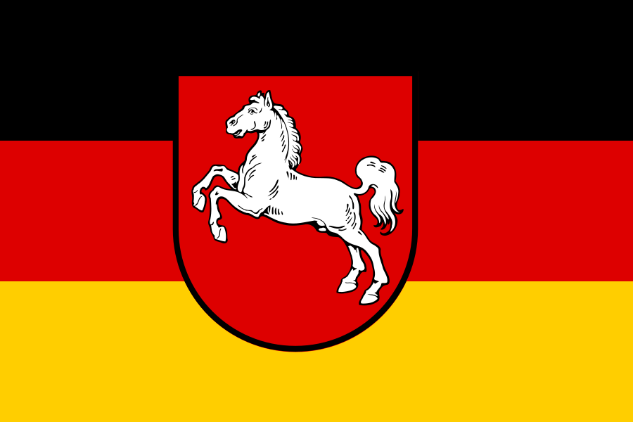
Lower Saxony at a glance
- Name
- Lower Saxony
- Country
- Germany
- Profile type
- German federal state
- Administrative seat in source record
- Hanover
- Establishment
- 1 November 1946
- Predecessor countries
- Hanover, Oldenburg, Braunschweig and Schaumburg-Lippe
- Sea
- North Sea
- Island group
- East Frisian Islands
- Well-known landscape
- Lüneburger Heide
- Southern Mountains
- Resin resin
- Natural heritage
- Transnational Wadden Sea
- Historical Symbolic Reference
- Sachsenross from Hannover and Braunschweig
The Flag of Lower Saxony
Three horizontal paths form the background: black above, red in the middle and gold below. Above it lies the red coat of arms with the jumping white horse. The additional coat of arms is crucial for the assignment, because the mere three background colors initially also make the German Federal flag think.
The Sachsenross has a much older history than today's Lower Saxony. It has already been used in the historical countries of Hanover and Braunschweig. After the founding of the state, it became the common sign of the new federal state. The horse should therefore not be explained as a representation of a single modern sporting or agricultural tradition, but as a handed down heraldic symbol.
Lower Saxony: Location and Territorial Role
Lower Saxony is located in northwestern Germany and has a coastal section on the North Sea. The state capital Hannover is the seat of the central political institutions. The country includes neither the whole of northern Germany nor all coastal regions of the Federal Republic. Its present form derives from political unions and borders, not only from a natural landscape unit.
The north with coast and East Frisian islands differs significantly from the Harz in the south. In between are the Lüneburg Heath and large-scale agricultural areas. At the same time, the State Office for Statistics emphasises economic diversity. A large weight of agriculture in the landscape does not mean that all working people work predominantly in this area.
Landscape, History and Culture
On the first November 1946, Lower Saxony emerged from Hanover, Oldenburg, Braunschweig and Schaumburg-Lippe. The four predecessor countries brought in different institutions and traditions. The new common country united them in an administrative order. On place names, cultural regions and historical buildings, the older references still remain recognizable and complement today's political map.
The name Lower Saxony is reminiscent of the Saxons and older regional terms. It does not denote a simple western part of today's Free State of Saxony. This name similarity can mislead in learning, because historical tribal spaces and modern borders follow different developments. This is why it is worthwhile to take a look at the independent history of the emergence of the Northwest German federal state.
The Wadden Sea is a particularly important natural area on the coast. As a transnational site, it is part of the UNESCO World Heritage Site and extends beyond Lower Saxony. Tides, sand and silt areas as well as constantly acting natural processes characterize the area. The recognition thus recognises a coherent habitat, the protection of which requires cooperation across borders.
East Frisian Islands
The East Frisian Islands are located off the North Sea coast of Lower Saxony. Its connection with Watt and sea explains a different landscape experience than inland. They are not detached points on a travel map, but part of a dynamic coastal space where water movement, sediments and human use are closely linked.
Lüneburger Heide
The Lüneburg Heath is a well-known scenic reference point between the large cities of the North German inland. It complements the coast and Harz with a third, significantly different space. For a country portrait, this comparison is particularly helpful: Lower Saxony has various landscapes that cannot be reduced to a single tourist landmark.
Resin resin
The Harz shows the southern mountain side of Lower Saxony. It crosses national borders and can therefore not be fully attributed to a single federal state. Together with the North Sea coast and Heide, it illustrates the span of the country. The white horse is a common symbol over these different natural spaces and historical regions.
Explore this country and nearby profiles
 Germany
 Munich
 Cologne
 Frankfurt am Main
 Stuttgart
 Düsseldorf
 Dresden
What did you discover?
Take this flag into the quiz
Sources and image credits
This English article draws on the institutional sources listed below. Figures and memberships retain their stated reference dates.
Source record: 2 November 2026. A translation does not change the reference date of a figure or membership list.
- niedersachsen.de/startseite/land_leute/das_land/wappen_flagge/wappen-und-flagge-19957.html
- niedersachsen.de/land_leute/geschichte/geschichte_landes_niedersachsen/19804.html
- statistik.niedersachsen.de/startseite/themen/gebiet_flachennutzung/gebiet_niedersachsens/niedersachsen-ein-land-stellt-sich-vor-191892.html
- whc.unesco.org/en/list/1314/
- niedersachsen.de/startseite/land_leute/die_geschichte/der_weg_zum_land_niedersachsen/-19881.html