Brandenburg: State Flag, Capital and Regional Profile
Brandenburg surrounds the independent capital region of Berlin with river landscapes, lakes and historic cities. Potsdam is his state capital. On the red-and-white flag stands the red Brandenburg eagle in the white shield. The country thus associates an old heraldic sign with a political figure that has existed in its present form since German reunification.
Test your knowledge →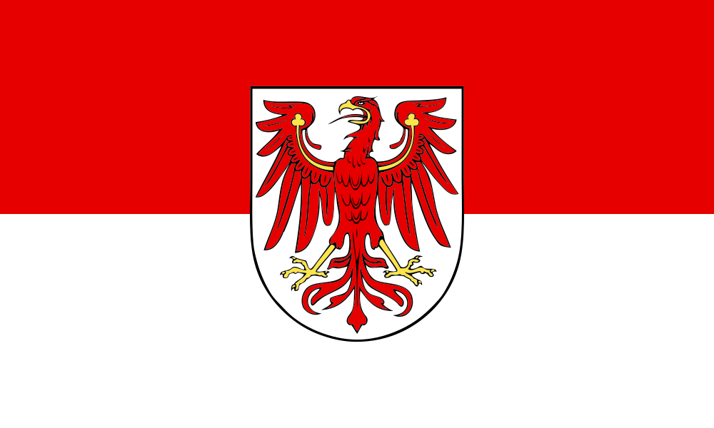
Brandenburg at a glance
- Name
- Brandenburg
- Country
- Germany
- Profile type
- German federal state
- Administrative seat in source record
- Potsdam
- Eastern neighbouring country
- Poland
- Large landscape
- North German lowlands
- Rivers
- Spree and Havel
- Further river
- Dams
- Lowering landscape
- Spreewald
- Historical reference
- Creation of the Mark Brandenburg 1157
- Restoration
- 3 October 1990
- World Heritage
- Palaces and parks of Potsdam and Berlin, since 1990
- Wetland area
- Lower Odertal
The Flag of Brandenburg
The flag has two equally wide horizontal stripes, red above and white below. In the middle is the coat of arms. The red eagle stands out clearly on its white shield; golden details complement the figure. Unlike a mere red-and-white two-strip flag, this version is clearly marked by the central coat of arms.
The landmark law describes the eagle with golden clover stems on its wings and golden reinforcement. The country flag carries this coat of arms expressly in the middle. The exact description helps to compare similar eagle signs that also occur elsewhere. The Brandenburg eagle is therefore not to be equated with any red bird.
Brandenburg: Location and Territorial Role
Brandenburg is located in the northeast of Germany and borders Poland in the east. The city of Berlin forms its own federal state. Potsdam, on the other hand, is part of Brandenburg and seat of its state government. Anyone who considers Berlin and Brandenburg as a common living or economic area should continue to pay attention to this political separation; proximity and interdependence do not abolish national borders.
The country belongs to the North German lowlands. Ice ages left a varied juxtaposition of lowlands, valleys, lakes and high altitudes. This shaping explains why water bodies and wetlands play such an important role. However, today’s image is also created by agriculture, settlements, drainage and the protection of particularly valuable landscapes.
Landscape, History and Culture
Among the dominating rivers are Spree, Havel, Rhin, Nuthe and Dahme. Their lowlands and the numerous lakes form contiguous landscape spaces. The Spreewald and the Oderbruch show different developments: both are water-impregnated, but their use and transformation each have their own historical prerequisites. A single lake is therefore not representative of the entire country.
The Mark Brandenburg is associated with the year 1157. It was not congruent with the present state. Later, Berlin and Potsdam became centers of the Kingdom of Prussia, which emerged in 1701. This prehistory explains the great density of residence buildings, churches and parks, without the present-day Brandenburg being identical with the former Prussian state.
The present-day federal state was re-established on 3 October 1990. Previously, the GDR had dissolved the countries as an administrative level. Brandenburg therefore combines a long historical heritage with a recent democratic history. The current national flag was subsequently established by law and is part of the political self-expression of the re-formed country.
Spreewald
The Spreewald is a characteristic lowland landscape with close connection to the water. It complements the pictures of castles and city proximity with another side of Brandenburg. His example shows how landscape forms can simultaneously influence traffic routes, settlement patterns and cultural traditions without completely separating natural and human influences.
Potsdam Parkland
The castles and parks of Potsdam and Berlin were included in the UNESCO World Heritage List in 1990. The site crosses the current national border. Sanssouci, Neuer Garten and Babelsberg are among their Potsdam components. Its value also lies in the relationships between buildings, gardens and views, not only in individual castle facades.
Lower Odertal
The Lower Oder Valley is an important wetland area on the eastern border. Together with the lower Havel and other lowlands, it makes the ecological role of Brandenburg’s water landscapes visible. These spaces complement the historical heritage with a natural perspective and explain why landscape protection in the country is an important task.
Explore this country and nearby profiles
 Germany
 Munich
 Cologne
 Frankfurt am Main
 Stuttgart
 Düsseldorf
 Dresden
What did you discover?
Take this flag into the quiz
Sources and image credits
This English article draws on the institutional sources listed below. Figures and memberships retain their stated reference dates.
Source record: 2 November 2026. A translation does not change the reference date of a figure or membership list.
- brandenburg.de/de/land/bb1.c.475252.de
- brandenburg.de/cms/detail.php/bb1.c.661006.de
- bravors.brandenburg.de/gesetze/hzg
- whc.unesco.org/en/list/532/