Zambia Flag, Capital and Country Facts
Zambia is located in southern Africa and has no marine access. Highlands, large river systems and copper mining characterize the country. Lusaka is the capital; the Zambezi connects different landscapes and partly forms a state border. The green flag shifts its main motif unusually far to the right: an orange eagle floats over three narrow stripes.
Test your knowledge →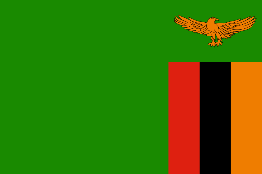
Zambia at a glance
- Capital
- Lusaka
- Quiz continent
- Africa
- Languages in reference record
- English (official); including Bemba, Nyanja, Tonga and Lozi
- Currency
- Zambian Kwacha (ZMW)
- Population
- 21,913,874 (2025, World Bank)
- Area
- 752,612 km²
- Coastal setting
- Landlocked
- ISO codes
- ZM / ZMB
- Internet country suffix
- .zm
- Independence
- 24 October 1964
- Former name
- Northern Rhodesia
- Large river
- Zambezi
- Former administrative centre
- Livingstone
- Mining region
- Copperbelt
- World Heritage
- Mosi-oa-Tunya / Victoria Falls, since 1989
Zambia Flag: Design, Meaning and History
The flag is mostly green. At the bottom right is a block of three vertical stripes in red, black and orange. Above it hovers an orange eagle. The main subject is therefore on the flying side and not, as with many other flags, in the middle or left top.
The Factbook Archive combines green with vegetation and natural resources, red with the struggle for freedom, black with the population and orange with mineral wealth. The eagle stands for the ability to overcome difficulties. The bird motif belongs to the national symbolism; in the quiz, its position above the strip block and the large green remaining area are particularly striking.
Capital: Lusaka
Lusaka is located on an elevated area in the southern part of the country. The name goes back to an older place and its local leader. The city is the capital and an important transport hub, but not on a sea coast: large urban centers of Zambia are also integrated in internal connections.
Before Lusaka, Livingstone was the administrative center of what was then North Rhodesia. The capital was moved in 1935. Livingstone remained known for its proximity to the Victoria Falls, while Lusaka took over the central political tasks. This change explains the different roles of both cities better than just using the most famous attraction as a capital feature.
Practise this capital →Zambia: Geography, History and Culture
Zambia consists mainly of high-altitude areas with hills and individual mountain areas. The Mafinga Central reaches 2,330 meters according to the Factbook archive. The altitude reduces the tropical temperatures of many regions. Rain and dry seasons structure agriculture and water management. The geographical classification as a South African tropical country therefore does not mean the same hot or wet weather all year round.
The Zambezi forms the border with Zimbabwe in sections. There are the Victoria Falls and the Karibasee. Rivers and reservoirs are important for power generation, agriculture, nature and cross-border relations. Although Zambia is a landlocked country, its waters connect it with a large area whose water eventually reaches the Indian Ocean.
Former British Northern Rhodesia became independent on 24 October 1964 as Zambia. The new name refers to the Zambezi. English is an official language; Bemba, Nyanja, Tonga, Lozi and many other languages are important in everyday life. Copper mining in the north is one of the dominant branches of the Factbook Archive and explains the special significance of the Copperbelt.
Mosi-oa-Tunya
The Victoria Falls also bear the name Mosi-oa-Tunya and have been joint world heritage sites of Zambia and Zimbabwe since 1989. The cases belong to the Zambezi. The cross-border entry makes it clear that a natural monument can be assigned to two states at the same time.
Copperbelt
The copper belt forms an important mining area in northern Zambia and continues across the border in the Democratic Republic of Congo. The deposits are based on geology. Therefore, the economic area cannot be explained solely by current state borders.
Kariba
Lake Kariba lies on the Zambezi border with Zimbabwe and was created by damming. It is thus an artificial body of water, not an original natural lake. Its importance shows how technical interventions and natural river systems shape the landscape together.
Explore neighbouring and related places
 Angola
 Botswana
 Democratic Republic of the Congo
 Malawi
 Mozambique
 Namibia
What did you discover?
Sources and image credits
This English article draws on the institutional sources listed below. Figures and memberships retain their stated reference dates.
Source record: 2 November 2026. A translation does not change the reference date of a figure or membership list.
- github.com/factbook/factbook.json/blob/144d6977b2b01ac1cbd220de754c0a005616760b/africa/za.json
- data.worldbank.org/indicator/SP.POP.TOTL
- whc.unesco.org/en/statesparties/zm
- cabinet.gov.zm/
- github.com/mledoze/countries