Namibia Flag, Capital and Country Facts
Namibia lies in southwestern Africa between the Atlantic Ocean, the Namib Desert and the dry landscapes of the inland countryside. The flag combines a red oblique stripe with a golden sun. Windhoek is located in the central highlands. Large distances, very different water availability and the history of colonial rule and liberation still shape the country today.
Test your knowledge →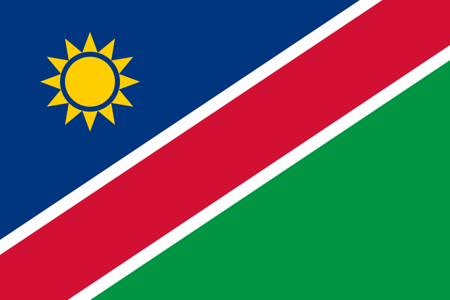
Namibia at a glance
- Capital
- Windhoek
- Quiz continent
- Africa
- Languages in reference record
- English as an official language; spread among others Oshiwambo languages, Khoekhoegowab, Afrikaans and Otjiherero
- Currency
- Namibia dollar (NAD); South African rand (ZAR) also legal tender
- Population
- 3,092,816 (2025, World Bank)
- Area
- 825,615 km²
- Coastal setting
- Not landlocked
- ISO codes
- NA / NAM
- Internet country suffix
- .na
- Highest point
- Königstein in the Brandberg, 2,573 m
- Independence
- 21 March 1990
- Coastal desert
- Namib
- Ocean flow
- Benguela stream
- Large port
- Walvis Bay
- Known salt pan
- Etosha pan
Namibia Flag: Design, Meaning and History
A wide red stripe rises from the bottom left to the top right. Narrow white borders separate it from the blue triangle on the top left and the green triangle on the bottom right. In the blue field stands a golden sun with twelve rays. The white border is an important feature and does not belong to an additional large area of color.
The flag was introduced for independence in 1990. Blue is associated with sky and Atlantic, green with vegetation, red with the efforts of the population and white with peace. The sun stands for life and energy. These assignments summarize national hopes; they do not automatically describe uniform living conditions in all regions.
Capital: Windhoek
Windhoek is located in the central highlands and is the capital and administrative center. The altitude distinguishes the city from the fog and desert spaces on the coast. Important transport links converge here. The main seaport Walvis Bay, on the other hand, is located on the Atlantic Ocean: political capital and maritime access fulfill different functions in different locations.
Among other things, the cityscape contains traces of the German colonial period and later South African rule. These buildings are in a larger historical context of dispossession, violence and resistance. A purely picturesque view would shorten this story. Windhoek is at the same time a large African city today with diverse languages and social experiences.
Practise this capital →Namibia: Geography, History and Culture
The Namib runs along the Atlantic coast. The cold Benguela stream contributes to dry coastal conditions and frequent fog. Further inside, the highlands rise; in the east, the Kalahari reaches into the state. The contrasts between dunes, rocky landscapes, savannahs and river spaces are larger than the simple designation Desertland would suggest. The Orange River forms a long border with South Africa in the south. The transboundary rivers on the edge are in clear contrast to the extremely dry central desert areas.
English is an official language, although many other languages are more widely used in everyday life. Oshiwambo languages, Khoekhoegowab, Afrikaans and Otjiherero represent different linguistic spaces. The administrative language must therefore not be confused with the mother tongue of the entire population. Historical mobility and today’s cities also create multiple overlaps.
Namibia became independent on 21 March 1990. The factbook archive stand of 2025 cites, among other things, mining, fishing and tourism as economic foundations. The low population density does not mean an unused or historical landscape. Rock paintings, pasture farming and long local histories document human relationships with dry spaces, which are also important for their protection today.
Namib Sand Sea
The Namib Sand Sea is a UNESCO World Heritage Site. The dune landscape is closely related to coastal fog and the special conditions of the Atlantic Desert.
Twyfelfontein
Twyfelfontein or /Ui-//aes is a World Heritage Site because of its rock engravings. The site documents a long human presence in a region that is now sparsely populated.
Brandberg
In the Brandberg Massif lies the Königstein, the highest point in Namibia. The inland mountains complement the often dominant images of flat dune landscapes.
Explore neighbouring and related places
 Angola
 Botswana
 South Africa
 Zambia
What did you discover?
Sources and image credits
This English article draws on the institutional sources listed below. Figures and memberships retain their stated reference dates.
Source record: 2 November 2026. A translation does not change the reference date of a figure or membership list.
- github.com/factbook/factbook.json/blob/144d6977b2b01ac1cbd220de754c0a005616760b/africa/wa.json
- data.worldbank.org/indicator/SP.POP.TOTL
- whc.unesco.org/en/statesparties/na
- github.com/mledoze/countries