Malawi Flag, Capital and Country Facts
Malawi is a long landlocked country in southeastern Africa. Lake Malawi occupies a large part of its eastern boundary and shapes traffic, fishing and landscape. Lilongwe is the capital, while Blantyre forms another important city center. The flag shows a rising red sun over the colors black, red and green.
Test your knowledge →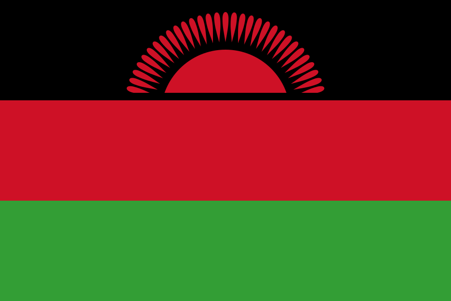
Malawi at a glance
- Capital
- Lilongwe
- Quiz continent
- Africa
- Languages in reference record
- English; Chichewa and other languages
- Currency
- Malawi kwacha (MWK)
- Population
- 22,216,120 (2025, World Bank)
- Area
- 118,484 km²
- Coastal setting
- Landlocked
- ISO codes
- MW / MWI
- Internet country suffix
- .mw
- Highest summit
- Sapitwa in the Mulanje Massif, 3,002 m
- Great lake
- Malawi/Nyasa
- Outflow of the lake
- Shire
- Former name
- Nyasaland
- Independence
- 6 July 1964
- Former capital
- Zomba
Malawi Flag: Design, Meaning and History
Three horizontal stripes of equal height lie on top of each other in black, red and green. In the upper black stripe appears a rising red sun with rays. The sun is only partially visible and does not stand as a complete white disc in the center; thus, the present flag can be distinguished from an earlier variant.
The Factbook archive connects black with the African population, red with the struggle for freedom and green with nature. The rising sun stands for hope for freedom on the African continent. Sequence and sun shape are important in common for recognition, because the same basic colors also occur in several other African flags.
Capital: Lilongwe
Lilongwe is located in the central part of Malawi inland and is named after the River Lilongwe. The capital function was moved here from Zomba in 1975. This historical change explains why older depictions call yet another political center and why the current capital name is not to be equated with the former colonial center.
Blantyre is an important economic and city centre in the south. The capital and the biggest economic focus must therefore be kept apart. Lilongwe’s more central location within the long-stretched countryside differs from the southern historical centers. For orientation, this north-south distribution is more helpful than a look at the capital alone.
Practise this capital →Malawi: Geography, History and Culture
Lake Malawi belongs to the East African trench fracture system. From its shores, the terrain rises to elevated areas and individual mountain massifs. The Sapitwa in the Mulanje massif reaches 3,002 meters. The altitude reduces the tropical climate of many regions; lake shore, plateau and mountainous land therefore offer different conditions despite the relatively narrow state form.
The Shire drains Lake Malawi south to the Zambezi. Although Malawi is a landlocked country, it is connected by its water system with a large river area of southern Africa. Fishing and agriculture are very important. This makes the distinction between coastal location and inland waters particularly clear: a country can have no sea access and yet extensive water landscapes.
English and Chichewa play important national roles, and there are also numerous other languages. The former British protectorate of Nyasaland became independent on 6 July 1964 as Malawi. The lake was also named Nyasa. State, waters and historical designations thus overlap without the present state borders covering the entire sea area alone.
Lake as a Natural Heritage Site
Malawi National Park became a UNESCO World Heritage Site in 1984. It protects part of the sea and shore landscape, not the entire lake. The entry makes the ecological importance of inland waters visible and complements Malawi’s image as an agricultural country.
Chongoni
The rock art area of Chongoni has been a World Heritage Site since 2006. The site documents cultural relationships between people and landscape. It extends the view beyond the sea and wildlife to historical expressions inland.
Mulanje
The cultural landscape of Mount Mulanje was added to the UNESCO list in 2025. This makes the massive not only interesting as a high mountain. The current entry also appreciates its cultural significance and complements the older natural and rock art tradition of the country.
Explore neighbouring and related places
 Mozambique
 Tanzania
 Zambia
What did you discover?
Sources and image credits
This English article draws on the institutional sources listed below. Figures and memberships retain their stated reference dates.
Source record: 2 November 2026. A translation does not change the reference date of a figure or membership list.
- github.com/factbook/factbook.json/blob/144d6977b2b01ac1cbd220de754c0a005616760b/africa/mi.json
- data.worldbank.org/indicator/SP.POP.TOTL
- whc.unesco.org/en/statesparties/mw
- lcc.mw/about-us/
- github.com/mledoze/countries