Vanuatu Flag, Capital and Country Facts
Vanuatu consists of an elongated island chain in the southwestern Pacific Ocean. Volcanoes, narrow coastal plains and a great linguistic diversity characterize the state. Port Vila is located on Efate. The flag combines red and green with a yellow Y and a wild boar hew; its shape is reminiscent of the arrangement of the islands and combines them with cultural symbols.
Test your knowledge →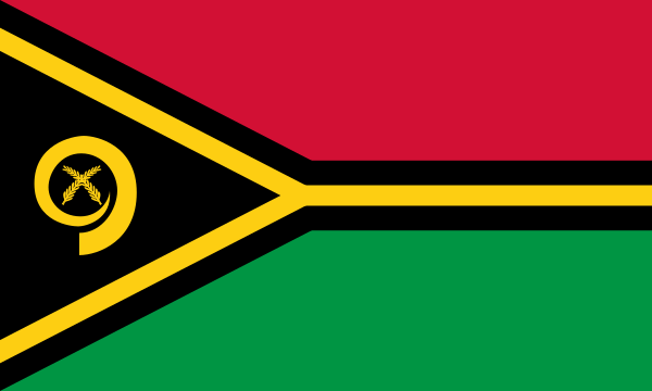
Vanuatu at a glance
- Capital
- Port Vila
- Quiz continent
- Oceania
- Languages in reference record
- Bislama, English and French (official languages); more than one hundred indigenous languages
- Currency
- Vatu (VUV)
- Population
- 335,169 (2025, World Bank)
- Area
- 12,189 km²
- Coastal setting
- Not landlocked
- ISO codes
- VU / VUT
- Internet country suffix
- .vu
- Highest point
- Tabwemasana, 1.877 m
- Largest island
- Espiritu
- Capital Islands
- Efate
- Other city centre
- Luganville
- Former name
- New Hebrides
- Independence
- 30 July 1980
Vanuatu Flag: Design, Meaning and History
The right half of the flag is red at the top and green at the bottom. There is a black triangle on the mast. A yellow, black bordered horizontal Y follows the dividing lines and opens to the mast. In the black triangle are a yellow curved wild boar hew and two crossed namel shrimp leaves. It is precisely this small sign that distinguishes the flag from a purely geometric division.
The Y takes up the approximate arrangement of the archipelago and is interpreted religiously at the same time. Green refers to the richness of the islands, black to the ni-vanuatu population. The Hauer stands for prosperity and has a cultural connection; the fern leaves are associated with peace. The flag was introduced for independence in 1980, combining landscape, society and historical reorganization.
Capital: Port Vila
Port Vila is located on a bay on Efate and is the capital of Vanuatu. The island lies in the middle to southern part of the chain; the capital is not on the largest island Espiritu Santo. Port and air connections make the city a central access point for exchange between islands and with foreign countries.
Luganville on Espiritu Santo forms another important urban center. The distinction between capital island and largest island helps with orientation in an archipelago whose individual land areas are far apart. Sea and air routes are crucial for the management and supply; a road-related connection of all parts of the country would not be geographically possible.
Practise this capital →Vanuatu: Geography, History and Culture
Most islands are of volcanic origin and have mountainous interiors with narrow coastal plains. The Tabwemasana on Espiritu Santo reaches 1,877 meters. Active volcanoes, earthquakes and tropical cyclones are among the natural hazards. These processes not only characterize spectacular landscapes, but also influence settlement locations, agriculture and the resilience of transport and supply networks.
The islands extend from north to south over a large marine space. Coasts, reefs and mountain forests form different habitats on a comparatively small land area. The boundaries between individual island societies are not determined solely by water distances: Traditional relationships, trade and cultural exchange connect places, while each island can preserve its own linguistic and historical characteristics.
Bislama is an English-based Creole language and serves as the official language alongside English and French. In addition, there are more than a hundred indigenous languages. The colonial name New Hebrides is reminiscent of the joint British-French administration before 1980. This dual colonial reference explains part of today’s multilingualism; however, the much greater indigenous linguistic diversity extends far beyond this European administrative history.
Chief Roi Mata’s Domain
The area became a UNESCO World Heritage Site in 2008. The entry connects several places with the handed down history of the chief Roi Mata and makes visible cultural landscape instead of a single monument.
Espiritu
On the largest island, Tabwemasana is also the highest mountain. The capital is nevertheless on Efate, which clearly distinguishes size and political centrality from each other.
Three official languages
Bislama, English and French exist side by side. Their official status describes only a part of the linguistic landscape, because numerous local languages remain important for individual island communities.
Explore neighbouring and related places
 Australia
 Federated States of Micronesia
 Fiji
 Kiribati
 Marshall Islands
 Nauru
What did you discover?
Sources and image credits
This English article draws on the institutional sources listed below. Figures and memberships retain their stated reference dates.
Source record: 2 November 2026. A translation does not change the reference date of a figure or membership list.
- github.com/factbook/factbook.json/blob/144d6977b2b01ac1cbd220de754c0a005616760b/australia-oceania/nh.json
- data.worldbank.org/indicator/SP.POP.TOTL
- whc.unesco.org/en/statesparties/vu/
- github.com/mledoze/countries