Nauru Flag, Capital and Country Facts
Nauru is a small island country in the central Pacific, just south of the equator. It has a narrow coastal strip and an interior heavily altered by phosphate mining. There is no officially designated capital. The quiz therefore asks for Yaren District as the seat of government and explicitly explains this special case.
Test your knowledge →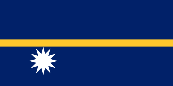
Nauru at a glance
- Seat of government
- Yaren District
- Quiz continent
- Oceania
- Languages in reference record
- Nauruan and English
- Currency
- Australian Dollar (AUD)
- Population
- 12,025 (2025, World Bank)
- Area
- 21 km²
- Coastal setting
- Not landlocked
- ISO codes
- NR / NRU
- Internet country suffix
- .nr
- Headquarters
- Yaren District
- Number of districts
- 14
- Inland waters
- Buada lagoon
- Independence
- 31 January 1968
- Historical raw material
- Phosphate
- Flag star
- Twelve points
Nauru Flag: Design, Meaning and History
Nauru has no officially designated capital. Government offices are in Yaren District.
The flag has a dark blue background with a narrow horizontal yellow stripe in the middle. To the left below the stripe stands a large white star with twelve peaks. The position is important: the star is not centrally on the band and not above it. Already the arrangement forms a small geographical sketch.
The yellow band stands for the equator, the star for the island to the south of it. Its twelve tips refer to the traditional tribes of Nauru. Blue stands for the Pacific; white is associated with the phosphate that has decisively shaped the economic history of the island. The motif thus combines geographical location, society and an important raw material.
Seat of government: Yaren District
Nauru does not have an officially designated capital. Yaren is a district in the south where central state institutions are located. The capital name Yaren is therefore a practical short form for the seat of government. It should not be understood as an ordinary city name with the same meaning as London or Paris.
Institutional country profiles also point to this special case, such as UNCTAD with the formulation Yaren without an official capital. On a very small island, administrative functions and settlement areas are more closely connected than in a territorial state. The district name therefore serves as orientation, without this being followed by a legally officially named capital status.
Practise this capital →Nauru: Geography, History and Culture
The island lies only a little south of the equator and is surrounded by a coral reef. Inside is an elevated plateau, while many settlements are concentrated on the coast. The central Buada lagoon is another geographical feature. Coastal stripes, plateaus and inland waters form distinctly different spaces despite the small area.
Phosphate mining generated significant revenues, but also left heavily altered surfaces in the interior of the island. The landscape therefore makes economic history immediately recognizable. A mineral deposit can be very important for a small state at times and at the same time raise long-term questions about usable soil, restoration and economic development. This is more than an isolated statistical feature.
Nauruan is an independent language, English fulfills additional public functions. State independence was achieved in 1968. Nauru joined the UNESCO World Heritage Convention in 2024, as documented by the official country profile. However, such accession does not automatically mean that the country's sites are already on the World Heritage List. Contract membership and recognition of individual places are different steps.
Flag as a location plan
The star under the equator band illustrates the location of the island. The twelve peaks, on the other hand, have a social-historical reference.
Headquarters in the District
Yaren is a district and not an officially designated capital. The special case is directly part of the capital response and should not be omitted.
Phosphate characterizes the terrain
The earlier mining is visible in the interior of the island. The history of raw materials and today’s landscape can therefore be particularly closely linked.
Explore neighbouring and related places
 Australia
 Federated States of Micronesia
 Fiji
 Kiribati
 Marshall Islands
 New Zealand
What did you discover?
Sources and image credits
This English article draws on the institutional sources listed below. Figures and memberships retain their stated reference dates.
Source record: 2 November 2026. A translation does not change the reference date of a figure or membership list.
- github.com/factbook/factbook.json/blob/144d6977b2b01ac1cbd220de754c0a005616760b/australia-oceania/nr.json
- data.worldbank.org/indicator/SP.POP.TOTL
- whc.unesco.org/en/statesparties/nr
- dgff2021.unctad.org/nauru/index.html
- github.com/mledoze/countries