Marshall Islands Flag, Capital and Country Facts
The Marshall Islands consist of scattered atolls and islands in the central Pacific Ocean. Their small land area is opposed to a large ocean extent. Majuro is also the name of the capital atoll and the urban center there. The history of the state combines Micronesian shipping with colonial administrations, American escrow and the significant consequences of earlier nuclear weapons tests.
Test your knowledge →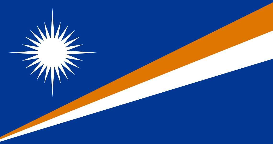
Marshall Islands at a glance
- Capital
- Majuro
- Quiz continent
- Oceania
- Languages in reference record
- Marshallese and English
- Currency
- US dollar (USD)
- Population
- 36,282 (2025, World Bank)
- Area
- 181 km²
- Coastal setting
- Not landlocked
- ISO codes
- MH / MHL
- Internet country suffix
- .mh
- Island chains
- Ralik and Ratak
- Independence
- 21 October 1986
- Constitutional Day
- 1 May
- Further settlement centre
- Ebeye
- Historical testatoll
- Bikini
- Capital areas
- Djarrit, Uliga and Delap
Marshall Islands Flag: Design, Meaning and History
On a blue background, the flag shows two diagonally rising stripes in orange and white. They become wider to the top right. On the left is a white star with four particularly long and twenty shorter rays. The combination of oblique bands and a multi-ray star distinguishes them from flags with simple rows of stars.
Blue stands for the Pacific. Orange and white are associated with the two island chains Ralik and Ratak, as well as sunset and sunrise. The star has 24 rays related to the constituencies; the four longer ones mark special centers. The diagonal can be read as the equator above which lies the archipelago.
Capital: Majuro
Majuro is an atoll, not a single large contiguous island body. The state institutions are concentrated in the Eastern Band of Djarrit, Uliga and Delap. The name of the capital therefore denotes a different type of settlement than a compact inland city on a continent.
The narrow land lies between the lagoon and the open ocean. Streets, houses and important facilities must be spaced side by side in a limited space. This structure explains why coastal protection and transport links are part of the capital geography. Ebeye in Kwajalein Atoll is another important settlement center, but not the national capital.
Practise this capital →Marshall Islands: Geography, History and Culture
The two main chains Ralik and Ratak run through the northern tropical Pacific Ocean. Many atolls consist of coral islands around a lagoon and reach only low altitudes. An atoll is not the same as a single island: it can comprise numerous small pieces of land, which are separated by water and still form a common ring.
Long before modern maps, Marshallian navigation and seafaring used a differentiated knowledge of waves, currents, stars and island relationships. The current official language Marshallese is one of the Micronesian languages; English is also official. The connections between the atolls are therefore both technical transport issues and part of a long cultural history of life in the ocean.
Bikini became known through American nuclear weapons tests and the resulting displacement of his population. UNESCO took the test site in 2010 as a testimony of the nuclear age. This World Heritage status is not a tourist safety certificate, but a historical tribute with regard to destruction and long-term consequences. The Marshall Islands have been independent since 1986 and are linked to the United States by a treaty of free association.
Bikini as a place of remembrance
The atoll has been a UNESCO World Heritage site since 2010. The recognition refers to the nuclear test history and its consequences for people and landscape.
Two island chains
Ralik and Ratak mean sunset and sunrise in the common translation. The two color bands of the flag pick up this double structure.
Capital on narrow land
Majuro distributes important functions over interconnected island areas. This makes the political capital a vivid example of atoll settlement.
Explore neighbouring and related places
 Australia
 Federated States of Micronesia
 Fiji
 Kiribati
 Nauru
 New Zealand
What did you discover?
Sources and image credits
This English article draws on the institutional sources listed below. Figures and memberships retain their stated reference dates.
Source record: 2 November 2026. A translation does not change the reference date of a figure or membership list.
- github.com/factbook/factbook.json/blob/144d6977b2b01ac1cbd220de754c0a005616760b/australia-oceania/rm.json
- data.worldbank.org/indicator/SP.POP.TOTL
- whc.unesco.org/en/list/1339
- github.com/mledoze/countries