Federated States of Micronesia Flag, Capital and Country Facts
The Federated States of Micronesia consists of widely scattered archipelagos in the western Pacific. The state name denotes only part of the larger geographical region of Micronesia. On the light blue flag are four white stars for the four member states; the capital Palikir is on Pohnpei and not on a specially named capital island.
Test your knowledge →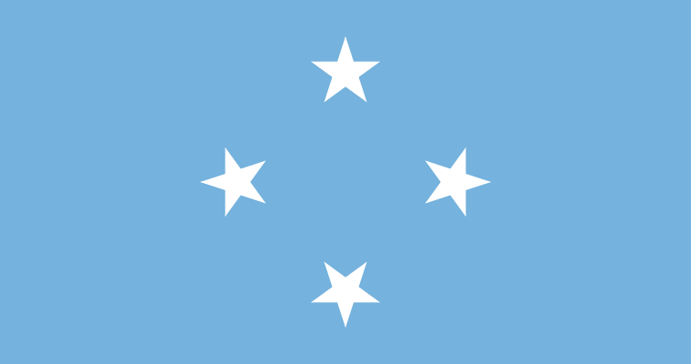
Federated States of Micronesia at a glance
- Capital
- Palikir
- Quiz continent
- Oceania
- Languages in reference record
- English and, inter alia, Chuukese, Kosraean, Pohnpeian and Yapesian
- Currency
- US dollar (USD)
- Population
- 113,683 (2025, World Bank)
- Area
- 702 km²
- Coastal setting
- Not landlocked
- ISO codes
- FM / FSM
- Internet country suffix
- .fm
- Member States
- Chuuk, Kosrae, Pohnpei and Yap
- Capital Islands
- Poohnpei
- Capital since
- 1989
- Former capital
- Colonia
- Highest point
- Nanlaud on Pohnpei, 782 m (archive 2025)
- World Heritage
- Nan Madol, since 2016
Federated States of Micronesia Flag: Design, Meaning and History
Four white five-pointed stars form a diamond-shaped arrangement on a light blue background. A star stands at the top, one at the bottom and one at the sides. The flag has neither stripes nor coats of arms. For recognition, the number four and the wide light blue background are therefore the most important features.
The stars stand for Chuuk, Kosrae, Pohnpei and Yap, the four member states of the Federation. Light blue refers to the Pacific Ocean, which surrounds and connects the island groups. The comparison with other Pacific star flags is worthwhile: here no single constellation of stars is shown, but symbolizes the political division of the state into four island groups.
Capital: Palikir
Palikir is located on Pohnpei in the eastern part of the Federation and became the capital in 1989. The Factbook Archive distinguishes the new seat of government explicitly from the former centre of Kolonia. The capital is thus an administrative location within an archipelago; from the name of the country, its location cannot be immediately read on the map.
Kolonia remains an important place on Pohnpei. In the allocation, a similar sounding confusion should also be avoided: Pohnpei is an island and a member state, Palikir the federal capital. Other member states have their own local centers. The federal system thus reflects the great distances and autonomy of the various island companies.
Practise this capital →Federated States of Micronesia: Geography, History and Culture
The territory includes both high islands of volcanic origin and shallow coral atolls. Pohnpei and Kosrae possess mountainous island interior; atolls, on the other hand, appear as low rings around lagoons. This difference is significant for water availability, soil and settlement areas. A single image of a flat sand island would therefore greatly shorten the geography of the Federation.
The actual land area is small compared to the sea space between the islands. Traffic and supplies depend on ship and air connections; distances are often more important in everyday life than the size of a single island. The Federation also covers two time zones. The sea is thus neither a mere boundary nor an empty area between independent places.
English serves as a common administrative and transport language, while several island languages continue to exist. Historical developments vary from island group to island group. The state is linked to the US by a free association treaty and uses the US dollar. This relationship does not mean equating with a US state; its own federation has a separate state identity.
Nan Madol
The ceremonial center in eastern Micronesia became a UNESCO World Heritage site in 2016. The site on Pohnpei points to a complex history of political and ceremonial centers before European colonial rule.
Four Member States
Chuuk, Kosrae, Pohnpei and Yap together form the Federation. Exactly these four names help to connect the flag’s four stars with real island spaces.
Micronesia is more than this state
The geographical region of Micronesia includes other island states and territories. The Federated States of Micronesia are therefore not to be equated with the entire Greater Pacific Region.
Explore neighbouring and related places
 Australia
 Fiji
 Kiribati
 Marshall Islands
 Nauru
 New Zealand
What did you discover?
Sources and image credits
This English article draws on the institutional sources listed below. Figures and memberships retain their stated reference dates.
Source record: 2 November 2026. A translation does not change the reference date of a figure or membership list.
- github.com/factbook/factbook.json/blob/144d6977b2b01ac1cbd220de754c0a005616760b/australia-oceania/fm.json
- data.worldbank.org/indicator/SP.POP.TOTL
- whc.unesco.org/en/statesparties/fm/
- github.com/mledoze/countries