Kiribati Flag, Capital and Country Facts
Kiribati consists of widely scattered island groups in the central Pacific Ocean. The land areas are small, but the distances over the sea are enormous. The flag shows a frigate bird over sun and waves. South Tarawa is the administrative center, while the Phoenix and Line Islands extend the state far beyond the Gilbert archipelago.
Test your knowledge →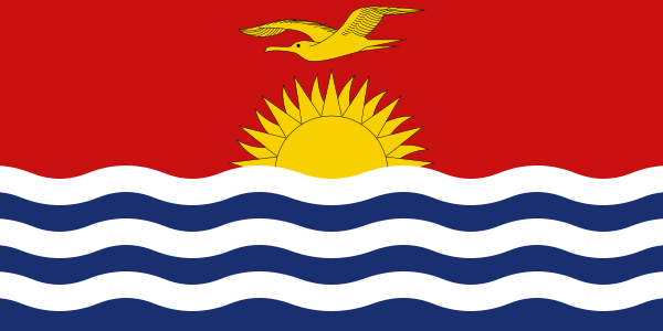
Kiribati at a glance
- Capital
- South Tarawa
- Quiz continent
- Oceania
- Languages in reference record
- Kiribati (Gilbertese) and English
- Currency
- Australian Dollar (AUD); own Kiribati coins in circulation
- Population
- 136,488 (2025, World Bank)
- Area
- 811 km²
- Coastal setting
- Not landlocked
- ISO codes
- KI / KIR
- Internet country suffix
- .ki
- Independence
- 12 July 1979
- Highest archive value
- Banaba, 81 m
- Atoll of the capital
- Tarawa
- Three main groups
- Gilbert, Phoenix and Line Islands
- Large atoll of the Line Islands
- Kiritimati
- Flag bird
- Fregat bird
Kiribati Flag: Design, Meaning and History
The upper half of the flag is red. On it, a yellow frigate bird flies over a yellow rising sun. At the bottom, blue ocean surfaces alternate with three white wave bands. Bird, sun rays and waves form a complete landscape, unlike flags with a single star or simple horizontal stripes.
The three white waves are assigned to the Gilbert, Phoenix and Line island groups. The Sun has 17 rays connected to the 16 Gilbert Islands and Banaba. The frigate bird stands for freedom and authority in national symbolism. The motif goes back to the former coat of arms and was transferred to the national flag in 1979 for independence.
Capital: South Tarawa
South Tarawa is located on the Tarawa atoll in the Gilbert Islands. The capital is not a single compact city on a large landmass, but extends over narrow island areas on the southern edge of the atoll. Roads and dams connect important settlements. The proximity of the lagoon and the open sea thus shapes the entire urban space.
The concentration of administration, education and services leads to a high demand on the limited land area. At the same time, other islands of the state are very far away. A common state name does not mean short everyday journeys: air and ship connections are essential for cohesion, while the lagoon is only a local, not a national transport area.
Practise this capital →Kiribati: Geography, History and Culture
Many islands are low coral atolls. Banaba is distinctly different from this as an uplifted island and contains the highest natural point of the state. Coastal erosion, saltwater input and the availability of fresh water are central geographical topics. Sea level rise interacts with local changes and weather events; the islands are not uniform, immovable sand plates. South Tarawa is just one section of a much larger atoll space. This distinction between atoll, individual island and urban administrative area helps to correctly classify seemingly contradictory locations in maps.
Kiribati is an independent Micronesian language, English belongs to the administrative and educational environment. The sea is a resource and a connection, but at the same time a great distance between communities. Fishing and maritime exploitation rights therefore play a different role than in states whose economies are mainly organised via interconnected land routes.
Independence from the United Kingdom took place in 1979. The factbook archive status of 2025 describes the widely separated groups as one state over several time zones. The Phoenix Islands Protected Area shows the dimension of the marine space particularly clearly. However, World Heritage status does not automatically mean that all economic use is permanently excluded; concrete protection rules can change.
Phoenix Islands
The Phoenix Islands Protected Area is a UNESCO World Heritage Site. The entry concerns a large ocean area and not only individual inhabited places.
Banaba
Banaba is an uplifted island with earlier phosphate mining. It differs significantly in the relief and in the history of use from the low atolls.
Three island groups
Gilbert, Phoenix and Line Islands explain the large spatial extent. The same tripartite division appears in the traditional interpretation of white flag waves.
Explore neighbouring and related places
 Australia
 Federated States of Micronesia
 Fiji
 Marshall Islands
 Nauru
 New Zealand
What did you discover?
Sources and image credits
This English article draws on the institutional sources listed below. Figures and memberships retain their stated reference dates.
Source record: 2 November 2026. A translation does not change the reference date of a figure or membership list.
- github.com/factbook/factbook.json/blob/144d6977b2b01ac1cbd220de754c0a005616760b/australia-oceania/kr.json
- data.worldbank.org/indicator/SP.POP.TOTL
- whc.unesco.org/en/statesparties/ki
- github.com/mledoze/countries