Türkiye Flag, Capital and Country Facts
Turkey is located with Anatolia mainly in Asia and with Eastern Thrace partly in Europe. Ankara has been the capital since 1923, while Istanbul is the famous city on Bosporus and the Sea of Marmara. Mountains, highlands and three large adjoining sea spaces explain the diverse geography of a state that is often equated with a single historical metropolis.
Test your knowledge →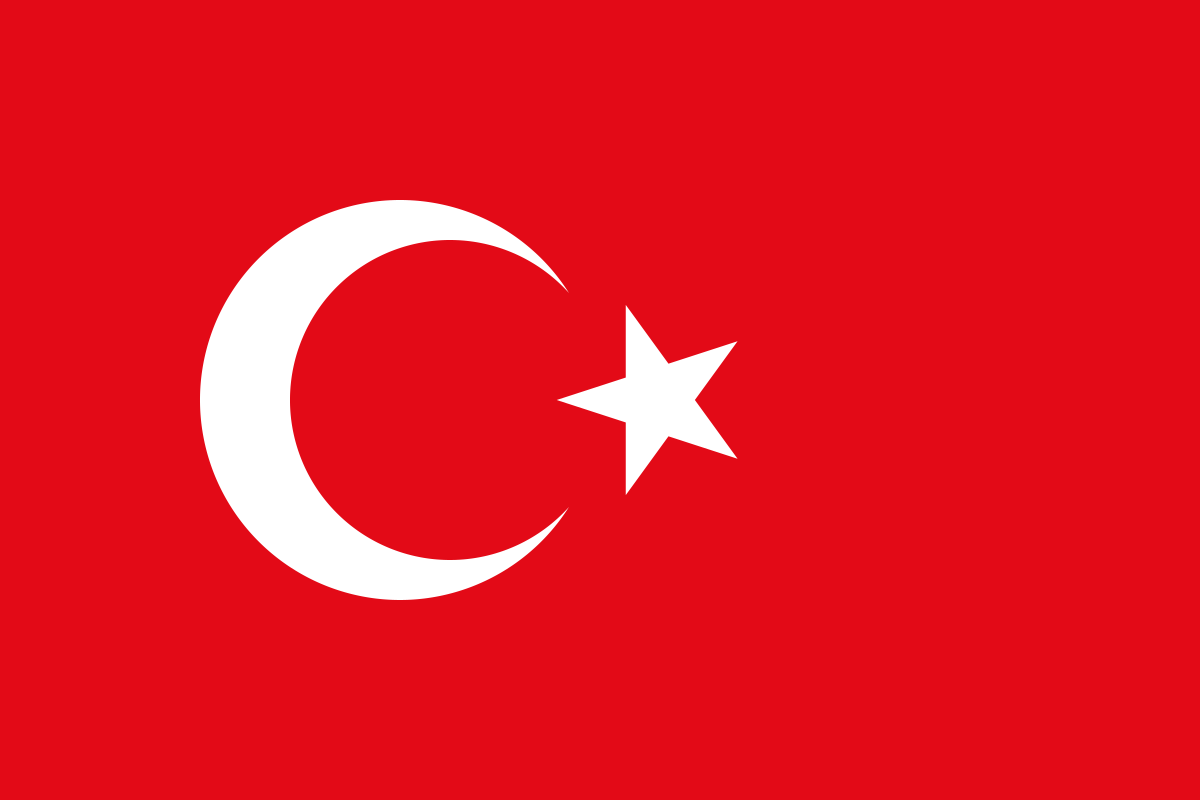
Türkiye at a glance
- Capital
- Ankara
- Quiz continent
- Asia
- Languages in reference record
- Turkish; also including Kurdish and other minority languages
- Currency
- Turkish lira (TRY)
- Population
- 85,878,556 (2025, World Bank)
- Area
- 783,562 km²
- Coastal setting
- Not landlocked
- ISO codes
- TR / TUR
- Internet country suffix
- .tr
- Highest mountain
- Ararat, 5,137 m according to the archive
- Establishment of the Republic
- 29 October 1923
- Capital since
- Ankara since 1923
- Part of Europe
- Eastern Thrace
- Straits of Istanbul
- Bosporus
- UNESCO rock landscape
- Cappadocia / Göreme
Türkiye Flag: Design, Meaning and History
The flag shows a white crescent moon and a white five-pointed star on a red background. The open side of the crescent points to the star. There are no stripes, no borders and no additional inscription. The clear two-colouredness is a good distinguishing feature compared to related red-white flags with different proportions or differently arranged signs.
The crescent moon and star are based on the Ottoman state tradition. Their prehistory is older and multi-layered; a single legend does not provide a complete historical explanation. Narratives of a reflection in blood or water should therefore be expressly referred to as tradition. For flag science, the proven reference to the Ottoman drawing world is sufficient.
Capital: Ankara
Ankara is located in the Anatolian Inland Highlands. The election as capital in 1923 belongs to the founding history of the republic. Istanbul, despite its size, history and international fame, remained without today’s capital function. The contrast is a particularly important point of learning: the largest or most famous city and political center are not automatically the same place.
Ankara’s internal situation is distinctly different from Istanbul’s position on a strait. The former European name Angora is encountered in historical texts and in names for animal fibres. It refers to the same city history, but is not today's quiz answer. Capital knowledge combines modern state history with older place names.
Practise this capital →Türkiye: Geography, History and Culture
Anatolia includes a high inner plateau and several mountain ranges. According to the Factbook archive, the Ararat reaches 5,137 meters. There are different conditions on the coasts than in the more continental inland. The Black Sea, the Aegean and the Mediterranean create different maritime landscapes, while Eastern Thrace forms the European part of the country and should not be equated with all of Istanbul or all of Anatolia.
Bosporus, Sea of Marmara and Dardanelles connect the Black Sea and the Aegean. This sequence explains the strategic location of Istanbul and the importance of the straits. The geographical transition between Europe and Asia is immediately visible here, while Ankara as the capital is located in a completely different location inland.
UNESCO runs numerous sites of different eras, including Troy, Ephesus, Hattusha and Göbekli Tepe. Cappadocia connects special rock landscapes with stone-worked buildings; Pamukkale combines natural forms and ancient city history. This diversity shows that the territory of present-day Turkey encompasses many historical societies and cannot be explained only from a single epoch.
Ankara instead of Istanbul
The relocation of the capital is in connection with the founding of the republic in 1923. If you distinguish the two cities by their location, the connection is easier: Ankara is located in the inland highlands, Istanbul on the straits between Europe and Asia.
Cappadocia
The UNESCO site around Göreme combines natural rock shapes with human-made spaces. The interaction is crucial: not only the geology and not only individual buildings explain the special character of this landscape used over a longer period of time.
Many historical layers
Troy, Hattusha and Ephesus represent different historical contexts. Their situation in today’s territory does not mean that they belonged to the same culture or epoch. A good country overview separates modern political borders from the older spaces of history.
Explore neighbouring and related places
 Armenia
 Azerbaijan
 Bulgaria
 Georgia
 Greece
 Iran
What did you discover?
Sources and image credits
This English article draws on the institutional sources listed below. Figures and memberships retain their stated reference dates.
Source record: 2 November 2026. A translation does not change the reference date of a figure or membership list.
- github.com/factbook/factbook.json/blob/144d6977b2b01ac1cbd220de754c0a005616760b/middle-east/tu.json
- data.worldbank.org/indicator/SP.POP.TOTL
- whc.unesco.org/en/statesparties/tr/
- github.com/mledoze/countries