Armenia Flag, Capital and Country Facts
Armenia lies in the South Caucasus between high mountains and the valley of the Aras. The inland country combines its own writing and a long Christian history with a landscape of volcanic cones, gorges and the Great Lake Sevan. For the flag quiz, especially the unusual combination of red, blue and orange is important.
Test your knowledge →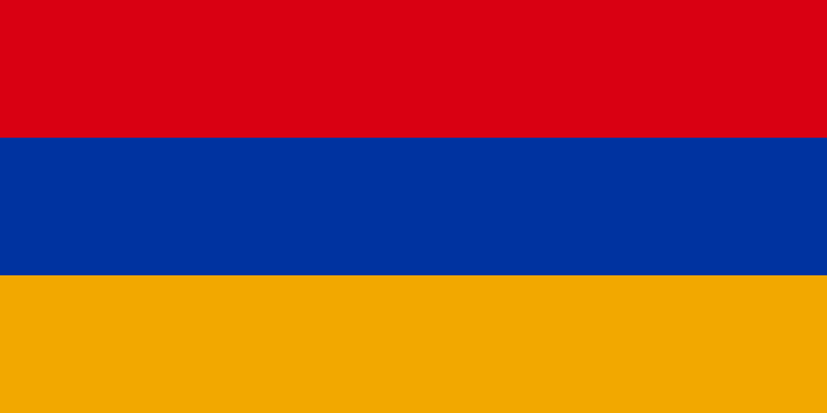
Armenia at a glance
- Capital
- Yerevan
- Quiz continent
- Asia
- Languages in reference record
- Armenian
- Currency
- Armenian Dram (AMD)
- Population
- 3,086,700 (2025, World Bank)
- Area
- 29,743 km²
- Coastal setting
- Landlocked
- ISO codes
- AM / ARM
- Internet country suffix
- .am
- Highest mountain
- Aragaz, 4.090 m
- Great lake
- Lake Sevan
- The River of the Capital
- Hrasdan
- Neighbor in the south
- Iran
- Independence
- 21 September 1991
- Own writing
- hayastan
Armenia Flag: Design, Meaning and History
Three equally wide horizontal stripes form the Armenian flag: red above, blue in the middle and orange below. There is neither a coat of arms nor a star. Especially the orange lower stripe distinguishes the motif from many other red-blue tricolors; the arrangement must therefore be considered completely.
The colors are based on the republic of 1918 and, after the end of the Soviet Union, became the state’s distinguishing mark again. The factbook archive of 2025 combines red with the struggle for freedom, blue with heaven and hope, and orange with the land and work of its inhabitants. Such interpretations complement the clearly recognizable design.
Capital: Yerevan
Yerevan is located in the west of the country on the Hrasdan, in the wider landscape of the Ararat basin. The capital is the political and economic center of Armenia. Its location differs significantly from the high-altitude Lake Sevan in the east: the most important settlement areas are concentrated on valleys and more usable plains.
The Erebuni Fortress was founded in 782 BCE in the area of present-day Yerevan. Thus, the city has a long history of settlements, even if the modern cityscape comes from very different eras. The name Yerevan is often associated with Erebuni; the exact language-historical derivation is not conclusively clarified.
Practise this capital →Armenia: Geography, History and Culture
The highest mountain within Armenia is the Aragaz. It must not be confused with the famous Ararat, which lies beyond the border in Turkey. Lake Sevan, on the other hand, belongs to the Armenian territory and is a large freshwater reservoir in the mountains. High altitudes and strong differences in relief lead to clear regional climate differences.
Armenian has its own script and belongs to the Indo-European language family. The Armenian Apostolic Church is important for numerous historical buildings. Monastery complexes are not only for religious tradition: their locations on gorges and mountain slopes also make visible the connection between architecture and landscape, which shapes the cultural image of the country.
Armenia became independent from the Soviet Union in 1991. For geographical contexts, its four neighbors Georgia, Azerbaijan, Iran and Turkey are crucial. A glance at the map explains the importance of mountain passes and land connections: the country does not have direct access to the sea. Border lines and transport links are therefore different things.
Monasteries in the north
Haghpat and Sanahin are on the UNESCO World Heritage List together. The two facilities complement the image of Armenia as a land of historic churches far beyond the capital.
Geghard and the Azattal
UNESCO runs the Geghard Monastery together with the upper valley of Azat. This explicitly highlights a connection between the building and the surrounding landscape.
Echmiadzin and Swartnoz
The cathedral and churches of Echmiadzin as well as the archaeological site of Swartnoz are also part of the World Heritage. They form another focal point west of Yerevan.
Explore neighbouring and related places
 Azerbaijan
 Georgia
 Iran
 Türkiye
What did you discover?
Sources and image credits
This English article draws on the institutional sources listed below. Figures and memberships retain their stated reference dates.
Source record: 2 November 2026. A translation does not change the reference date of a figure or membership list.
- github.com/factbook/factbook.json/blob/144d6977b2b01ac1cbd220de754c0a005616760b/central-asia/am.json
- data.worldbank.org/indicator/SP.POP.TOTL
- whc.unesco.org/en/statesparties/am
- github.com/mledoze/countries