Iran Flag, Capital and Country Facts
Iran stretches between the Caspian Sea, the Persian Gulf and the Gulf of Oman. High mountains surround wide highlands and dry basins. Tehran lies on the southern edge of the Elburs Mountains; historical cities, ancient irrigation systems and different language areas show why Iran cannot be reduced geographically and culturally to a desert landscape.
Test your knowledge →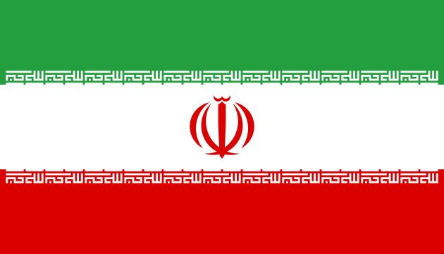
Iran at a glance
- Capital
- Tehran
- Quiz continent
- Asia
- Languages in reference record
- Persian (Farsi); also inter alia Azerbaijani, Kurdish, Arabic and Baloch
- Currency
- Iranian Rial (IRR)
- Population
- 92,417,681 (2025, World Bank)
- Area
- 1,648,195 km²
- Coastal setting
- Not landlocked
- ISO codes
- IR / IRN
- Internet country suffix
- .ir, ایران.
- Northern Mountains
- Elburs
- Western Mountains
- Zagros
- Historic residence
- Persepolis
- Traditional water technology
- Qanate
- UNESCO Palace in Tehran
- Golestan Palace
- Great desert landscape
- Lut Desert
Iran Flag: Design, Meaning and History
The flag has three horizontal stripes of equal height: green, white and red. In the white field stands a red stylized state sign. At the transitions to the white stripe, a white lettering appears repeatedly. The narrow font and the central sign distinguish the motif from a simple green-white-red tricolor.
The sign of the state is religiously shaped and stylizes the name of God. The repeated scripture is Allahu akbar. Green, white and red have common religious and political interpretations, but for accurate recognition, writing and emblem are more important than general color symbolism. The flag corresponds to the state structure introduced after the 1979 revolution.
Capital: Tehran
Tehran is located in the north of Iran’s inland highlands at the foot of the Elburs Mountains. Its position as a capital city can be distinguished from the location of historical cultural centers such as Isfahan, Schiras or Persepolis. These places have great historical importance, but do not fulfill the current capital function; the political map and a map of old residences show different focuses.
The proximity to the mountains characterizes the spatial orientation of the city. North the altitudes rise significantly, while south drier plains join. The Golestan Palace in Tehran is a UNESCO World Heritage site and illustrates the residence history of the cadsaries. Thus, the capital combines modern central functions with preserved testimonies of an older epoch of rule.
Practise this capital →Iran: Geography, History and Culture
Elburs in the north and Zagros in the west are among the formative mountains. In between are plateaus and dry basin spaces, including large desert areas. The coast on the Caspian Sea, on the other hand, forms a wetter landscape. The differences are closely related to relief and precipitation distribution; Iran therefore has very different regional environmental conditions.
Persian is the national official language, but many other languages are spoken. Azerbaijani, Kurdish, Arabic and Baloch are among important examples. The state name Iran and the historical designation Persia are not interchangeable in every context: Persian also denotes a language and a cultural tradition within a greater diversity.
UNESCO runs both cultural and natural sites, including Persepolis, Persian gardens, historical Qanat systems and the Lut Desert. Especially the Qanate show the connection between the environment and technology. Underground water pipelines developed water for settlements and agriculture in arid areas, documenting long-term adaptation to limited water resources.
Water Under the Earth
Qanate conducts water through underground channels. The UNESCO ensemble pays tribute to this technical tradition, which combines water extraction and community management. The facilities make visible how permanent settlement was made possible even in dry landscapes by carefully organized infrastructure.
Persepolis
The ruins of the Achaemenid residence are among Iran’s most famous historical sites. They stand for a much earlier epoch than the capital function of Tehran; to distinguish both places on a timeline is just as helpful as their spatial distinction.
Wet coast, dry basin
The contrast between Caspian coastal space and inner desert basins shows the effect of mountains on the climate. Those who expect only sand and drought overlook forests, high mountains and vastly different habitats within the same state.
Explore neighbouring and related places
 Afghanistan
 Armenia
 Azerbaijan
 Iraq
 Pakistan
 Türkiye
What did you discover?
Sources and image credits
This English article draws on the institutional sources listed below. Figures and memberships retain their stated reference dates.
Source record: 2 November 2026. A translation does not change the reference date of a figure or membership list.
- github.com/factbook/factbook.json/blob/144d6977b2b01ac1cbd220de754c0a005616760b/middle-east/ir.json
- data.worldbank.org/indicator/SP.POP.TOTL
- whc.unesco.org/en/statesparties/ir/
- github.com/mledoze/countries