Georgia Flag, Capital and Country Facts
Georgia lies between the Black Sea and the High Caucasus. The country connects humid western landscapes, mountain valleys and drier eastern basin spaces. Tbilisi is located to the east on the river Kura. The classification on the border of Europe and Asia makes Georgia a particularly vivid example of the fact that large geographical areas have different boundaries.
Test your knowledge →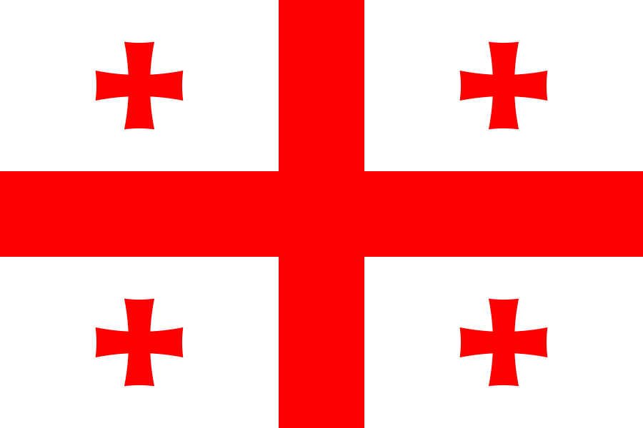
Georgia at a glance
- Capital
- Tbilisi
- Quiz continent
- Asia
- Languages in reference record
- Georgian; in Abkhazia, Abkhazian also has a special legal status
- Currency
- Georgian Lari (GEL)
- Population
- 3,935,766 (2025, World Bank)
- Area
- 69,700 km²
- Coastal setting
- Not landlocked
- ISO codes
- GE / GEO
- Internet country suffix
- .ge
- Highest mountain
- Schchara, 5,193 m according to the archive
- Capital river
- Kura / Mtkwari
- Western Sea
- Black Sea
- UNESCO mountain region
- Upper Swanetia
- Historical religious centre
- Mzcheta
- Natural heritage
- Colch forests and wetlands
Georgia Flag: Design, Meaning and History
A large red cross reaches on a white background to all four borders. In each of the four white fields stands a smaller red cross. The motif is therefore often called the five-cross flag. The smaller crosses have widened arms ends and thus differ somewhat from the straight main cross.
The pattern follows a medieval banner of the Kingdom of Georgia. The crosses belong to a Christian sign tradition. For recognition, their number is more helpful than a free interpretation of color: a large central cross and four smaller ones make up the characteristic five-way motif, which separates the flag from simple red-white cross flags.
Capital: Tbilisi
Tbilisi is the common name for Tbilisi in German. The capital is located on the Kura River, which is called Mtkwari in Georgian. So two city or river names can denote the same place. For the quiz, Tbilisi is the given German capital form; Tbilisi is no other capital next to it.
The Georgian city name is related to the word for warm and refers to the sulfur springs of the area. This connection between natural feature and place name offers a concrete notebook. Tbilisi is also located in a valley area, which is why the river, slopes and traffic axes contribute significantly to the understanding of its spatial development.
Practise this capital →Georgia: Geography, History and Culture
The Great Caucasus forms a mighty mountain zone in the north. According to the Factbook archive, the Schchara reaches 5,193 meters. In the west, the landscapes open to the Black Sea; in the east, different precipitation conditions prevail. The relief thus creates strong contrasts at a short distance, which only incompletely expresses a single label such as mountainous land.
The Georgian language has its own script and does not belong to the Slavic languages. This independence also helps to distinguish Georgia from its neighbours. Historical churches and monasteries are important cultural witnesses; UNESCO lists Mzcheta, Gelati and the mountain landscape of Upper Swanetia as World Heritage sites.
The Colchic rainforests and wetlands complement the cultural sites with a natural heritage on the Black Sea. They show a wet side of Georgia that is easily overlooked when only snow-capped Caucasus summits are in view. Here, scenic diversity is directly linked to the location between the sea, mountains and the more continental east.
Upper Swanetia
Historic villages and characteristic fortified towers stand here in a high mountain landscape. The UNESCO entry combines architectural history with a special form of settlement; the towers are therefore to be understood as part of a habitat and not only as isolated sights.
Colchic nature
Rainforests and wetlands on the Black Sea are a clear contrast to drier eastern parts of the country. Georgia thus possesses both high-alpine and exceptionally humid natural spaces, the differences of which can be explained by relief and proximity to the sea.
Own writing
Georgian characters are a visible feature of language history. Anyone who distinguishes the script from Cyrillic or Latin alphabets can recognize an important cultural reference on maps and signage without deriving a statement about all language skills of the population.
Explore neighbouring and related places
 Armenia
 Azerbaijan
 Russia
 Türkiye
What did you discover?
Sources and image credits
This English article draws on the institutional sources listed below. Figures and memberships retain their stated reference dates.
Source record: 2 November 2026. A translation does not change the reference date of a figure or membership list.
- github.com/factbook/factbook.json/blob/144d6977b2b01ac1cbd220de754c0a005616760b/central-asia/gg.json
- data.worldbank.org/indicator/SP.POP.TOTL
- whc.unesco.org/en/statesparties/ge/
- github.com/mledoze/countries