Bulgaria Flag, Capital and Country Facts
Bulgaria extends from the Danube to the Black Sea and from the plains in the north to high mountains in the southwest. The capital Sofia is located inland. Who connects the country only with its Black Sea coast, overlooks the mountain landscapes, monasteries and historical traffic routes between Central Europe, the Aegean and Anatolia.
Test your knowledge →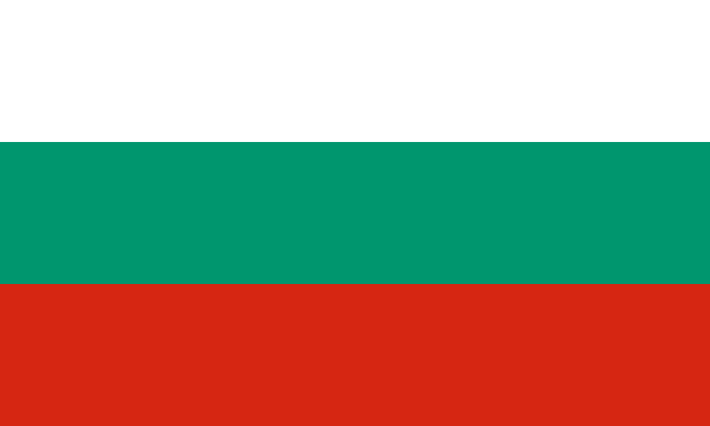
Bulgaria at a glance
- Capital
- Sofia
- Quiz continent
- Europe
- Languages in reference record
- Bulgarian
- Currency
- Euro (EUR; since 1 January 2026)
- Population
- 6,433,302 (2025, World Bank)
- Area
- 110,879 km²
- Coastal setting
- Not landlocked
- ISO codes
- BG / BGR
- Internet country suffix
- .bg
- Highest mountain
- Musala, 2,925 m
- Border flow
- Danube
- Sea
- Black Sea
- Written text
- Cyrillic
- Full independence
- 22 September 1908
- National holiday
- 3 March
Bulgaria Flag: Design, Meaning and History
The Bulgarian flag consists of three equally high horizontal stripes: white above, green in the middle and red below. It does not carry a coat of arms in the form used here. The direction of the stripes and the green center distinguish them from the Russian white-blue-red tricolor and from vertical tricolors.
The pattern was adopted in 1879 after the liberation from Ottoman rule. Green replaced the blue of a related Slavic color arrangement. Between 1948 and 1990, various state emblems were in the white field. Today’s simple form can thus also be read as a return to an older design; common color explanations call peace, agriculture and the struggle for independence.
Capital: Sofia
Sofia is located in a basin in the west of the country at the foot of the Vitosha Mountains. The capital is therefore neither on the Danube nor on the Black Sea. Its location on land connections across the Balkans explains a different part of Bulgaria’s geography than the more well-known coastal towns in the east.
The city became the capital of the then newly formed Bulgarian Principality in 1879. Ancient traces of settlements and later church buildings show that the place is considerably older than this capital role. For the quiz helps to distinguish between Sofia as a political center, Plovdiv as another historic city center and Varna as a port on the Black Sea.
Practise this capital →Bulgaria: Geography, History and Culture
The Danube forms the border with Romania for long distances. To the south of it, the Balkans and other mountain ranges divide the country into different landscape areas. In the Rila Mountains, the Musala reaches 2,925 metres, making Bulgaria one of the high mountain countries of southeastern Europe. Coastal plains and Danube lowlands are in clear contrast to these altitudes.
Bulgarian is a South Slavic language and is written with Cyrillic script. Monasteries were important places of religious and written tradition. Particularly well known is the Rila Monastery, whose history dates back to the tenth century. Its importance is not limited to an impressive facade: it also stands for the transmission of language, art and religious traditions.
The state development took place in several steps. The autonomous principality of 1878 was followed by complete independence from the Ottoman Empire in 1908. These data should not be combined into a single event. The factbook archive with mostly 2025 data serves as a historical basis here; the currency for this page was updated to the euro entry on 1 January 2026.
Rila Monastery
UNESCO has listed the monastery as a World Heritage Site since 1983. The complex is closely linked to the religious and cultural history of Bulgaria.
Danube and Sea
Bulgaria has both a long Danube border and a Black Sea coast. As a result, river ports and sea ports have different transport tasks.
Highest Balkan Mountain
The Musala rises in the Rila Mountains at 2,925 meters. It is not in the mountain range, which in the narrower sense is called Balkan Mountains.
Explore neighbouring and related places
 Greece
 North Macedonia
 Romania
 Serbia
 Türkiye
What did you discover?
Sources and image credits
This English article draws on the institutional sources listed below. Figures and memberships retain their stated reference dates.
Source record: 2 November 2026. A translation does not change the reference date of a figure or membership list.
- github.com/factbook/factbook.json/blob/144d6977b2b01ac1cbd220de754c0a005616760b/europe/bu.json
- data.worldbank.org/indicator/SP.POP.TOTL
- whc.unesco.org/en/list/216
- ecb.europa.eu/press/pr/date/2026/html/ecb.pr260101~c830245e42.en.html
- github.com/mledoze/countries