Azerbaijan Flag, Capital and Country Facts
Azerbaijan lies between the Caucasus and the Caspian Sea. The country connects high mountains, dry lowlands and the densely built peninsula Abşeron with the capital Baku. Nakhichevan is a geographical peculiarity: this exclave belongs to the state, but is separated from the rest of the territory. Ancient trading towns and modern oil industry form very different historical layers.
Test your knowledge →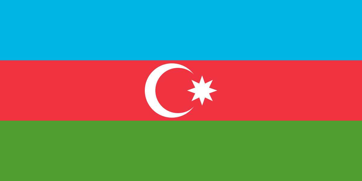
Azerbaijan at a glance
- Capital
- Baku
- Quiz continent
- Asia
- Languages in reference record
- Azerbaijan
- Currency
- Azerbaijan-Manat (AZN)
- Population
- 10,246,996 (2025, World Bank)
- Area
- 86,600 km²
- Coastal setting
- Landlocked
- ISO codes
- AZ / AZE
- Internet country suffix
- .az
- Highest mountain
- Bazardüzü, 4,466 m
- Large rivers
- Kura and Aras
- Inland waters
- Caspian Sea
- Exclave
- Nakhichevan
- Historical Republic
- Founded in 1918
- Cultural site
- Gobustane
Azerbaijan Flag: Design, Meaning and History
Three equally high stripes in light blue, red and green form the flag. In the center of the red stripe stand a white crescent moon and a white star with eight peaks. The eight peaks are an important distinguishing feature: in many other national flags next to a crescent, the star has only five.
The colors are associated with Turkish cultural heritage, modernization and Islam. The flag ties in with the Republic of 1918 and was adopted again in connection with the end of the Soviet era. Different historical interpretations exist for the eight star tips; their concretely visible form is sufficient for recognizing the flag, without assigning an unchanging individual meaning to each tip.
Capital: Baku
Baku is located on the west coast of the Caspian Sea on the peninsula Abşeron. The city centre is partly below the level of the world sea. This is not a contradiction to the coastal situation: the Caspian Sea is a drainless inland water with its own water level and no open connection to the ocean.
The walled old town with Shirvanschah Palace and Jungfrauenturm is a UNESCO World Heritage site. It stands next to younger neighbourhoods and plants of the oil industry. Baku is therefore at the same time the capital, port and a place where older trade connections and the industrial development of the Caspian region are immediately visible.
Practise this capital →Azerbaijan: Geography, History and Culture
In the north rises the Great Caucasus, while Kura and Aras shape a wide lowland. As the highest point, the Factbook archive mentions the Bazardüzü with 4,466 meters. Between mountains and deeper basins are strong climatic and scenic contrasts. The difference is greater than the comparatively small distance on a map of Europe suggests. Kura and Aras feed water from cross-border catchments.
The official language of Azerbaijan is one of the Turkic languages. Historical connections extend simultaneously into Persian, Russian and Caucasian cultural areas. UNESCO explicitly describes the old town of Baku as an urban ensemble with several cultural influences. This makes it clear why linguistic kinship alone does not fully explain the history of a country.
Access to the Caspian Sea enables shipping, but does not make Azerbaijan an open ocean access state geographically. The Nakhichevan exclave is also an inland territory. Oil and gas have had a strong impact on economic development; the country profile also includes agriculture, mountain settlements and traditional routes between summer and winter pastures.
Baku behind walls
UNESCO has been managing the walled city as a World Heritage Site since 2000. Jungfrauenturm and Shirvanschah Palace are among their striking buildings.
Rock paintings of Gobustan
The cultural landscape of Gobustan preserves thousands of rock engravings. They document a much longer history of settlement than the modern capital silhouette.
Separate Nakhchivan
The exclave lies outside the contiguous main area. Therefore, the state cannot be recorded on a political map with a single closed area.
Explore neighbouring and related places
 Armenia
 Georgia
 Iran
 Russia
 Türkiye
What did you discover?
Sources and image credits
This English article draws on the institutional sources listed below. Figures and memberships retain their stated reference dates.
Source record: 2 November 2026. A translation does not change the reference date of a figure or membership list.
- github.com/factbook/factbook.json/blob/144d6977b2b01ac1cbd220de754c0a005616760b/central-asia/aj.json
- data.worldbank.org/indicator/SP.POP.TOTL
- whc.unesco.org/en/statesparties/az
- github.com/mledoze/countries