Trinidad & Tobago Flag, Capital and Country Facts
Trinidad and Tobago is located on the southern edge of the Caribbean near Venezuela. The larger island of Trinidad and the northeastern Tobago together form the state, but have different landscape and economic profiles. Port of Spain is located on Trinidad. The flag is red and crossed by a black-and-white diagonal band, which manages without a coat of arms.
Test your knowledge →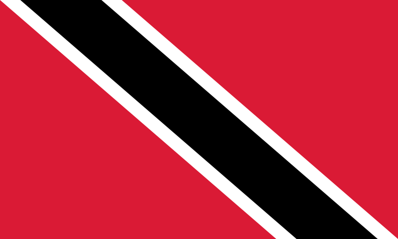
Trinidad & Tobago at a glance
- Capital
- Port of Spain
- Quiz continent
- North America
- Languages in reference record
- English (official language); Trinidadian and Tobagon Creole languages and other languages
- Currency
- Trinidad and Tobago Dollar (TTD)
- Population
- 1,367,764 (2025, World Bank)
- Area
- 5,130 km²
- Coastal setting
- Not landlocked
- ISO codes
- TT / TTO
- Internet country suffix
- .tt
- Highest point
- Cerro del Aripo, 940 m
- Capital Islands
- trinidade
- Bay of the capital
- Gulf of Paria
- Place of administration in Tobago
- Scarborough
- Natural asphalt deposit
- Pitch Lake at La Brea
- Independence
- 31 August 1962
Trinidad & Tobago Flag: Design, Meaning and History
A black band runs from the upper hoist side to the lower flight side over the red field. Narrow white stripes surround the black band on both sides. The direction of the diagonal is important: it falls in the usual representation from top left to bottom right. A star or other middle sign is missing.
The flag was introduced with independence in 1962. Their colours are associated with earth, water and fire; in addition, red stands for vitality, white for sea and equality, and black for land and determination. These symbolic interpretations complement the clear geometric design. However, the diagonal does not represent the exact location of the two main islands on a map.
Capital: Port of Spain
Port of Spain is located in the northwest of Trinidad on the Gulf of Paria. The capital is thus located on the larger of the two islands and opposite the South American mainland. Its English name goes back to the Spanish Puerto de España and preserves an older colonial reference within a later British-influenced history.
The city is the central political center; San Fernando in the south of Trinidad forms another important urban space. On Tobago, Scarborough is an important administrative and port city. This distribution shows why the double name of the state does not denote two capitals of the same name: the national capital is Port of Spain, while both islands have additional local centers.
Practise this capital →Trinidad & Tobago: Geography, History and Culture
Trinidad is located just off the Venezuelan coast and geographically belongs to the transition area between the Caribbean and the South American mainland. In the north rises the Northern Range; the Cerro del Aripo reaches 940 meters according to the factbook archive. Plains and lower hills characterize other island parts. Tobago is located northeast and has its own forested mountain range with the Main Ridge.
Pitch Lake near La Brea is a natural asphalt deposit on Trinidad. UNESCO lists him as well as the Tobago Main Ridge Forest Reserve and the Banwari Trace archaeological site. Inclusion in the list of proposals is not yet a World Heritage title. This distinction prevents a significant natural or cultural place from being equated with an already excellent world heritage.
English is an official language; Creole language forms and other linguistic traditions are part of everyday life. The population history was characterized, among other things, by African enslavement and later labor migration from India. Carnival, Calypso and Steelpan are in concrete historical developments and should not be treated as characteristics of each individual person. At the same time, the energy industry, services and tourism shape different parts of the economy.
Steelpan
Steelpan developed on Trinidad and is closely linked to its musical history. Its importance extends beyond the carnival and shows an independent tradition of instruments.
Pitch Lake
The natural asphalt deposit is on the UNESCO list of proposals. It draws attention to an unusual geological place next to the frequently mentioned beaches.
Tobagos Main Ridge
The forested mountain range forms a special natural space of the smaller main island. It is also on the list of proposals and cannot be equated with an already registered world heritage.
Explore neighbouring and related places
 Antigua & Barbuda
 Bahamas
 Barbados
 Belize
 Canada
 Costa Rica
What did you discover?
Sources and image credits
This English article draws on the institutional sources listed below. Figures and memberships retain their stated reference dates.
Source record: 2 November 2026. A translation does not change the reference date of a figure or membership list.
- github.com/factbook/factbook.json/blob/144d6977b2b01ac1cbd220de754c0a005616760b/central-america-n-caribbean/td.json
- data.worldbank.org/indicator/SP.POP.TOTL
- whc.unesco.org/en/statesparties/tt/
- github.com/mledoze/countries