Antigua & Barbuda Flag, Capital and Country Facts
Antigua and Barbuda connect two very different main islands: the more populated Antigua with numerous protected bays and the flatter Barbuda with its large lagoon. The small Caribbean state also includes Redonda. Its history can be seen on former sugar plantations as well as on the British naval facilities of English Harbour.
Test your knowledge →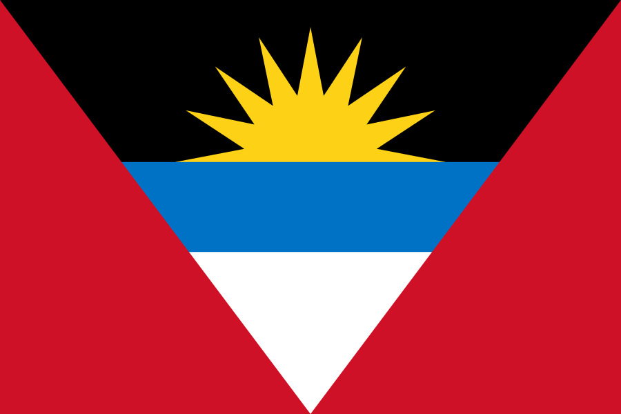
Antigua & Barbuda at a glance
- Capital
- Saint John's
- Quiz continent
- North America
- Languages in reference record
- English; in everyday life also Antiguan Creole
- Currency
- Eastern Caribbean Dollar (XCD)
- Population
- 94,209 (2025, World Bank)
- Area
- 442 km²
- Coastal setting
- Not landlocked
- ISO codes
- AG / ATG
- Internet country suffix
- .ag
- Independence
- 1 November 1981
- National holiday
- 1 November
- Highest point
- 402 m according to Factbook Archive 2025
- Another island
- Redondae
- Historical port
- English Harbour
- Location in Barbuda
- Codrington
Antigua & Barbuda Flag: Design, Meaning and History
The flag has red side faces and a large downward triangle. In it, black, blue and white follow each other; from the black field a yellow sun rises. The triangular composition clearly distinguishes them from the horizontal tricolors of many other Caribbean states. Together blue and white do not produce an independent heraldic shield.
The design was created in 1967, i.e. before the state independence of 1981. The archived factbook explains the sun as the beginning of a new era, black as an indication of African heritage and blue as hope. The V-shape stands for victory. Sun, sea and sand are an additional landscape-related reading of the three brighter colors.
Capital: Saint John's
Saint John’s is located in the northwest of Antigua on a natural harbor bay. This is where the central state institutions sit, and the port combines political capital function with trade and cruise tourism. The name refers to the apostle John. Barbuda has its own local centre, Codrington, but no second national capital.
The situation explains why Saint John’s and English Harbour should not be confused: the capital is located on a different coast than the historic naval base in the south. A country can own several significant ports, while administration and a particularly well-known cultural heritage remain spatially separated. This distinction also helps in learning the island map.
Practise this capital →Antigua & Barbuda: Geography, History and Culture
Antigua has strongly divided coasts with many bays; in the southwest there are higher volcanic landscapes. Barbuda is predominantly low and characterized by limestone and coral material. The Factbook archive mentions for the highest point Antiguas 402 meters. At short distances, relief, settlement density and the use of the coastline differ considerably.
The islands belonged to the British colonial area and became independent on 1 November 1981. Sugar plantations and enslaved African workers shaped their colonial economy; slavery was abolished in 1834. English administrative language and Creole everyday language refer to different levels of this history. The joint state is part of the Commonwealth and the East Caribbean monetary region.
The tropical ocean climate brings relatively low temperature fluctuations, but not an evenly safe water supply. Dry periods and tropical cyclones are among the main natural hazards. Hurricane Irma devastated Barbuda in 2017 and led to the evacuation of the population to Antigua. The unequal impact shows why even neighboring islands of a state can have very different disaster experiences.
Historical naval port
The Antigua Naval Dockyard and related archaeological sites have been on the UNESCO World Heritage List since 2016. The protected location of English Harbour was strategically important for the British fleet.
Two island centres
Saint John’s bundles the national functions on Antigua. In Barbuda, however, the settlement is concentrated around Codrington and its lagoon landscape.
A third island name
Redonda also belongs to the national territory. The state name therefore names the two main islands, but does not enumerate every associated island.
Explore neighbouring and related places
 Bahamas
 Barbados
 Belize
 Canada
 Costa Rica
 Cuba
What did you discover?
Sources and image credits
This English article draws on the institutional sources listed below. Figures and memberships retain their stated reference dates.
Source record: 2 November 2026. A translation does not change the reference date of a figure or membership list.
- github.com/factbook/factbook.json/blob/144d6977b2b01ac1cbd220de754c0a005616760b/central-america-n-caribbean/ac.json
- data.worldbank.org/indicator/SP.POP.TOTL
- whc.unesco.org/en/list/1499
- github.com/mledoze/countries