Bahamas Flag, Capital and Country Facts
The Bahamas is a widely scattered island nation in the Atlantic Ocean off Florida and Cuba. Flat limestone islands, light sandbanks and deep sea gutters are close together. Although the Bahamas are often named along with Caribbean destinations, they are geographically located in the Atlantic Ocean. Their flag translates sea, beach and community into three clear forms.
Test your knowledge →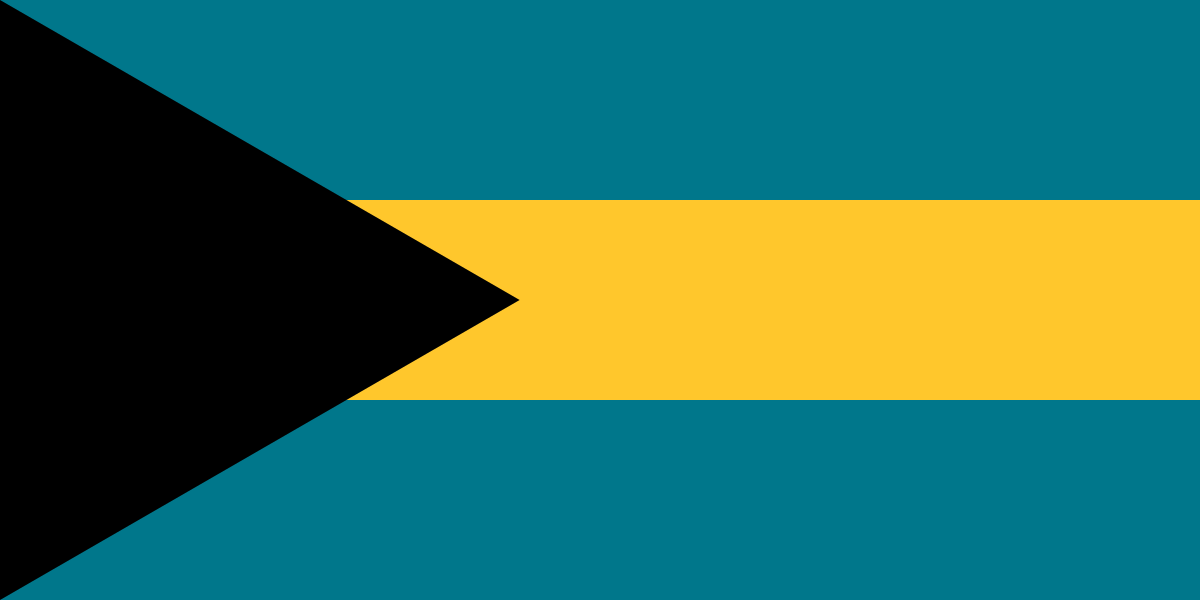
Bahamas at a glance
- Capital
- Nassau
- Quiz continent
- North America
- Languages in reference record
- English
- Currency
- Bahama dollar (BSD)
- Population
- 403,033 (2025, World Bank)
- Area
- 13,943 km²
- Coastal setting
- Not landlocked
- ISO codes
- BS / BHS
- Internet country suffix
- .bs
- Highest point
- Mount Alvernia, 63 m
- Island of the capital
- New Providence
- Independence
- 10 July 1973
- Large island
- Andros
- National waters
- Atlantic Ocean
- Historical State Name
- Commonwealth of the Bahamas
Bahamas Flag: Design, Meaning and History
Three equally wide horizontal stripes are aquamarine blue, golden yellow and again aquamarine blue. From the rod side, a black triangle reaches into the strips. It reaches to the center of the flag and forms its strongest dark contrast. Coats of arms, stars and British Union Jack do not belong to the national flag motif.
The flag was introduced for independence in 1973. Aquamarine is assigned to the sea and gold to the sandy beaches; the black triangle stands for the combined strength and determination of the population. This interpretation explains a national pictorial language without deriving from it a statement about the origin of each individual person. The triangle distinguishes the flag from simple tri-colored stripe flags.
Capital: Nassau
Nassau is located on New Providence, a comparatively small but densely populated island. The capital is a port, administrative centre and important transport hub. Its importance is therefore not based on the size of the island, but on historical trade links and the concentration of services. The numerous other islands are often grouped together as Family Islands.
The city was closely linked to British colonial rule and Atlantic shipping. Today, cruise port and tourism shape large parts of the cityscape and the economy. Nassau, however, is not synonymous with the entire archipelago: remote island communities have different distances, living conditions and transport links than the center on New Providence.
Practise this capital →Bahamas: Geography, History and Culture
The archipelago consists of islands, small cays and extensive flat benches. The low altitude makes coastlines particularly sensitive to storm surges. Tropical hurricanes are a recurring natural hazard. The border between land and sea is therefore not only a line on the map here, but an essential topic for settlements and infrastructure. The island state has no land border. National transport routes therefore run between islands by water or by air, while road traffic is limited to individual island areas.
The economic structure is strongly shaped by tourism and financial services. At the same time, the Bahamas are connected to their surroundings by shipping routes and proximity to the North American market. The factbook archive stand from 2025 describes an island state whose land area is small, but whose maritime extent is considerable. Distances between islands can be greater than a compact map suggests.
History includes the indigenous population before European expansion, colonization, enslavement and later independence. English is an official language; cultural expressions evolved from several historical connections. Today’s membership of the Commonwealth explains political traditions, while the national flag deliberately uses an independent image without a colonial corner motif.
Inagua
The Inagua National Park is on the UNESCO list of proposals. This preliminary stage must be explicitly distinguished from an already completed inclusion in the World Heritage List.
Historic lighthouses
The UNESCO list of proposals also mentions historical lighthouses of the Bahamas. They are reminiscent of the difficult navigation between flat benches and open Atlantic passages.
Highest point
Mount Alvernia on Cat Island reaches only 63 meters. Even the highest natural point thus shows how flat this island nation is overall.
Explore neighbouring and related places
 Antigua & Barbuda
 Barbados
 Belize
 Canada
 Costa Rica
 Cuba
What did you discover?
Sources and image credits
This English article draws on the institutional sources listed below. Figures and memberships retain their stated reference dates.
Source record: 2 November 2026. A translation does not change the reference date of a figure or membership list.
- github.com/factbook/factbook.json/blob/144d6977b2b01ac1cbd220de754c0a005616760b/central-america-n-caribbean/bf.json
- data.worldbank.org/indicator/SP.POP.TOTL
- whc.unesco.org/en/statesparties/bs
- github.com/mledoze/countries