Canada Flag, Capital and Country Facts
Canada stretches from the Atlantic to the Pacific and far into the Arctic. The second largest state in the world has huge forest areas, numerous lakes and mountains in the west. Its capital Ottawa, on the other hand, lies in the more densely populated south. The connection of English, French and indigenous languages is as important as the enormous extent on the map.
Test your knowledge →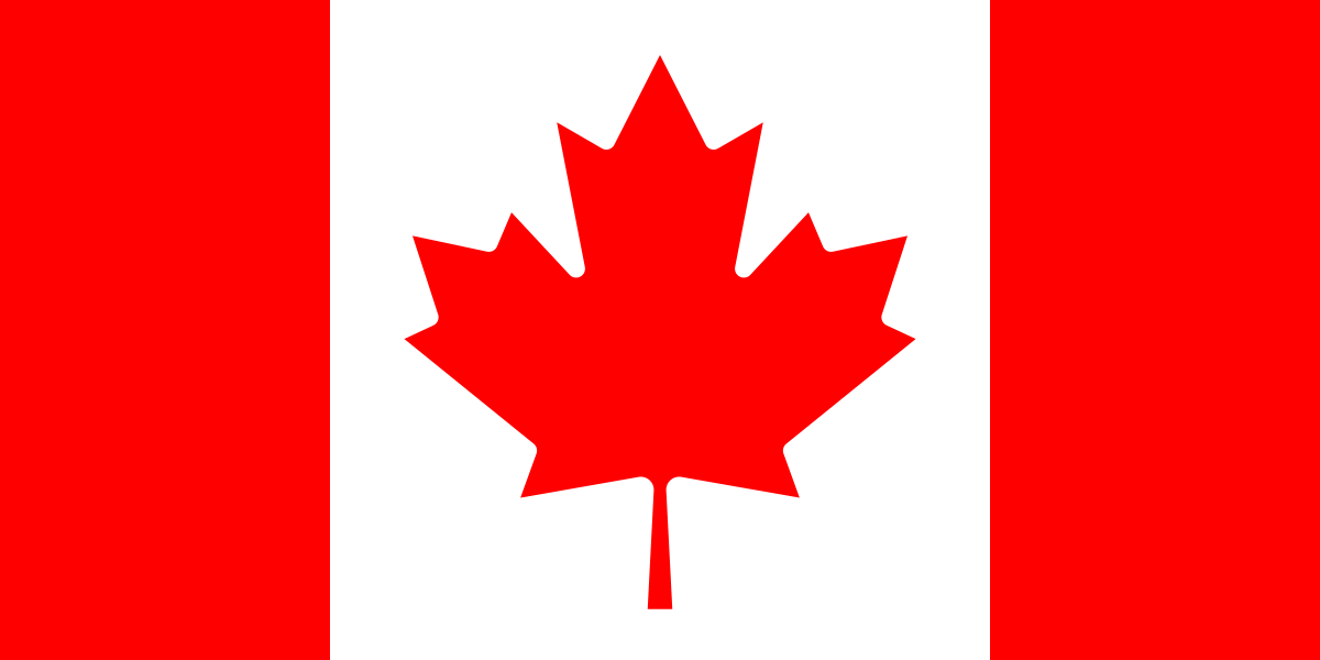
Canada at a glance
- Capital
- Ottawa
- Quiz continent
- North America
- Languages in reference record
- English and French at federal level; numerous indigenous languages
- Currency
- Canadian Dollar (CAD)
- Population
- 41,651,653 (2025, World Bank)
- Area
- 9,984,670 km²
- Coastal setting
- Not landlocked
- ISO codes
- CA / CAN
- Internet country suffix
- .ca
- Highest mountain
- Mount Logan, 5,959 m
- Federal breakdown
- 10 provinces and 3 territories
- National holiday
- 1 July
- Flag imported
- 15 February 1965
- Historical Canal
- Rideau Canal, 202 km
- Neighboring town of Ottawa
- Gatineau in Quebec
Canada Flag: Design, Meaning and History
The flag shows a red maple leaf on a white square framed by two red side panels. The leaf has eleven tips and is clearly stylized. The overall flag is twice as wide as it is high. Red and white as well as the single central leaf allow a quick distinction between flags with several plant motifs.
The maple leaf flag was introduced on February 15, 1965. The maple leaf was previously a Canadian mark of recognition. Its eleven tips are a graphic design and do not stand for the provinces or territories. This widespread mismatch can already be seen in the fact that Canada has ten provinces and three territories.
Capital: Ottawa
Ottawa is located in Ontario on the Ottawa River across from Gatineau in Quebec. The capital region thus touches the two populous provinces and two large language areas. The political capital is neither Toronto, the largest city, nor Montréal, the great French-speaking center. The spatial proximity of these different functions helps to classify the Canadian settlement geography.
The Rideau Canal connects Ottawa via a system of rivers, lakes and locks with Kingston on Lake Ontario. According to UNESCO, this historic waterway stretches over 202 kilometers. Originally built for military purposes, today it illustrates how waterways contributed to the development of settlements and the security of what was then British colonial territory.
Practise this capital →Canada: Geography, History and Culture
To the west run the Rocky Mountains, inside are prairies and large plains. Further east, ancient rocks of the Canadian Shield and numerous lakes characterize the landscape. The north includes tundra and Arctic islands. Mount Logan in the Yukon reaches 5,959 meters; its altitude is therefore a very different magnitude than the predominantly lower terrain around the capital.
Canada emerged in 1867 as a federation of several British colonies and developed its state independence in further steps. The 1st of July commemorates the Confederation as Canada Day. History also includes the long presence of the First Nations, Inuit and Métis as well as the consequences of colonial politics. This perspective extends far beyond the founding of today’s federal state.
The large area does not mean uniform settlement. Large parts of the population live in the south near the border with the United States. Climate, transport routes and economic connections contribute to this concentration. The numerous lakes and rivers are at the same time supplies of drinking water, habitats, traffic axes and energy sources; a seemingly empty area on the map can therefore be very important ecologically and culturally.
Waterway as a World Heritage Site
The Rideau Canal has been a UNESCO World Heritage site since 2007. Its locks and watercourses connect capital history with early engineering technology.
Three marine environments
Canada has coasts on the Atlantic, Pacific and Arctic Oceans. This location explains the very different conditions of its port and coastal towns.
Mountain in the Yukon
Mount Logan is the highest mountain in Canada. It is located far from the big cities in the southeast.
Explore neighbouring and related places
 United States
Cities and regions in this country
 Toronto
 Vancouver
 Ontario
 Quebec
What did you discover?
Sources and image credits
This English article draws on the institutional sources listed below. Figures and memberships retain their stated reference dates.
Source record: 2 November 2026. A translation does not change the reference date of a figure or membership list.
- github.com/factbook/factbook.json/blob/144d6977b2b01ac1cbd220de754c0a005616760b/north-america/ca.json
- data.worldbank.org/indicator/SP.POP.TOTL
- whc.unesco.org/en/list/1221
- canada.ca/en/canadian-heritage/services/flag-canada-description.html
- github.com/mledoze/countries