Costa Rica Flag, Capital and Country Facts
Costa Rica is located on the Central American land bridge between Nicaragua and Panama. The state has coasts on the Pacific and Caribbean, while mountain ranges and volcanoes rise inside. This narrow location explains the rapid change between warm coastal landscapes and significantly cooler altitudes around the capital San José.
Test your knowledge →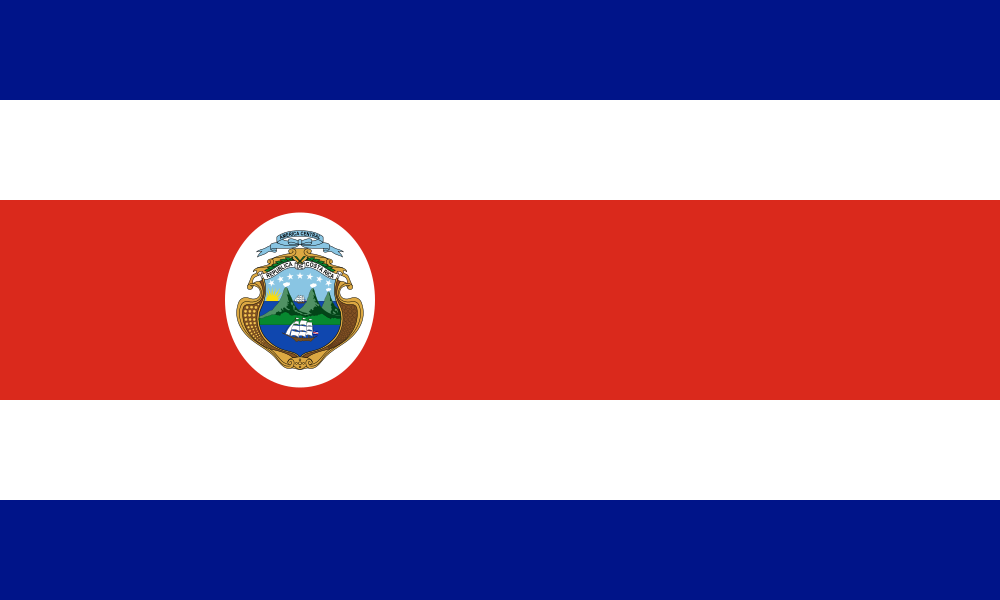
Costa Rica at a glance
- Capital
- San José
- Quiz continent
- North America
- Languages in reference record
- Spanish; also, among others, indigenous languages and English
- Currency
- Costa Rica Colon (CRC)
- Population
- 5,152,950 (2025, World Bank)
- Area
- 51,100 km²
- Coastal setting
- Not landlocked
- ISO codes
- CR / CRI
- Internet country suffix
- .cr
- Highest mountain
- Cerro Chirripó, 3.819 m
- National holiday
- 15 September
- National bird
- Yigüirro, a type of throttle
- Cross-border park
- La Amistad with Panama
- Archaeological heritage
- Stone balls of the Diquís area
- Pacific Island
- Coconut Island
Costa Rica Flag: Design, Meaning and History
Five horizontal stripes follow each other in the order of blue, white, red, white and blue. The red middle strip is twice as wide as the rest. In the state flag, the coat of arms sits offset to the left in the red field. For the quick comparison, especially the wide red stripe and the blue outer stripes are decisive.
The current color design was created in 1848 from the older blue-white-blue Central American tradition. The addition of red was influenced by French colors. Thailand offers a helpful juxtaposition: There the outer stripes are red and the broad center blue, so just in reverse.
Capital: San José
San José is located in the central highlands and thus neither directly on the Pacific nor on the Caribbean. Its location belongs to the important settlement area of the Valle Central. The capital therefore shows why the population distribution of Costa Rica cannot be explained solely via the two coasts: the interior has its own economic and political focus.
The name is reminiscent of Saint Joseph. The city grew from a settlement of the 18th century to the state center. The altitude provides for different climatic conditions than on many lowland coasts. On a journey through the country, temperature differences can therefore be noticed as well as the change between big cities, volcanic slopes and tropical coasts.
Practise this capital →Costa Rica: Geography, History and Culture
Between the two seas lies a mountainous backbone. The Cerro Chirripó reaches 3,819 meters and is higher than the known volcanoes in the vicinity of the capital. Tropical climate here does not mean the same heat everywhere: altitude, slope and the different moisture supply from the seas create different landscape and vegetation spaces.
Costa Rica’s UNESCO natural sites open up very different ecosystems. The Guanacaste Protected Area includes habitats in the northwest; the La Amistad International Park connects the country with Panama. The Coconut Island, on the other hand, is far out in the Pacific Ocean. A small country can thus protect natural spaces that are spatially and ecologically separated from each other.
In addition to the natural heritage, the pre-Columbian stone balls of the Diquís area belong to the UNESCO World Heritage site. The archaeological sites are reminiscent of organized societies before European colonization. Spanish is the most important nationwide language, but indigenous languages and communities are also part of the country’s history and today’s cultural spectrum.
Stone balls instead of volcanoes
The Diquís sites add an archaeological theme to Costa Rica’s well-known natural image. Their carefully worked stone balls belong to settlement sites and should be understood as evidence of human design, not as randomly rounded nature formations.
An International Protected Area
La Amistad stretches across Costa Rica and Panama. The name means friendship and fits the cross-border context: mountain forests and their biodiversity form a common natural space, even if the administration is divided between two states.
Two coasts, one highland
The Pacific and Caribbean surround the same narrow state, but the capital lies in between in the highlands. This simple tripartite division helps with learning more than the assumption that a Central American country consists predominantly of flat tropical beaches.
Explore neighbouring and related places
 Nicaragua
 Panama
What did you discover?
Sources and image credits
This English article draws on the institutional sources listed below. Figures and memberships retain their stated reference dates.
Source record: 2 November 2026. A translation does not change the reference date of a figure or membership list.
- github.com/factbook/factbook.json/blob/144d6977b2b01ac1cbd220de754c0a005616760b/central-america-n-caribbean/cs.json
- data.worldbank.org/indicator/SP.POP.TOTL
- whc.unesco.org/en/statesparties/cr/
- github.com/mledoze/countries