Belize Flag, Capital and Country Facts
Belize is located on the Caribbean coast of Central America and connects coral reefs with tropical forests and Mayan sites. English has a special position here in a predominantly Spanish-speaking neighborhood. The unusually detailed flag shows two people and reminds of the historical significance of the timber trade; the capital Belmopan is deliberately located off the coast.
Test your knowledge →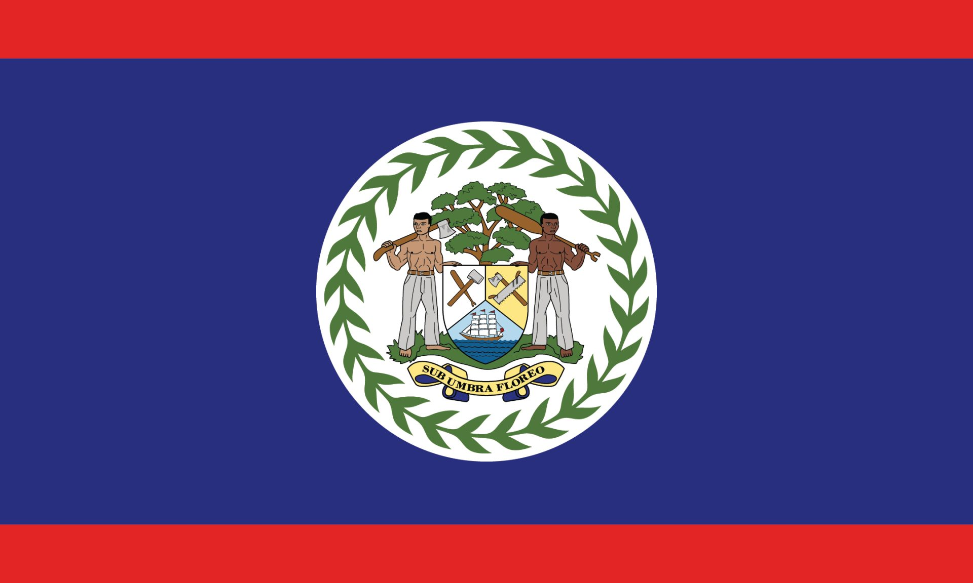
Belize at a glance
- Capital
- Belmopan
- Quiz continent
- North America
- Languages in reference record
- English (official language), also including Spanish, Belizean Creole, Mayan languages and Garifuna
- Currency
- Belize dollar (BZD)
- Population
- 422,924 (2025, World Bank)
- Area
- 22,966 km²
- Coastal setting
- Not landlocked
- ISO codes
- BZ / BLZ
- Internet country suffix
- .bz
- Former name
- British Honduras
- Independence
- 21 September 1981
- Highest point
- Doyle’s Delight, 1.124 m
- Mountains
- Mayan Mountains
- Former capital
- Belize City
- World Heritage
- Belize Barrier Reef Reserve System, since 1996
Belize Flag: Design, Meaning and History
The main blue field is bordered by narrow red stripes at the top and bottom. In a white circle in the middle is the coat of arms of the state. Two human shield holders, a tree, tools, a ship and a green ring of leaves make the flag a particularly figurative representation among the national flags.
The coat of arms refers to the colonial timber industry, especially the mahogany trade. The Latin motto Sub umbra floreo can be reproduced as “I bloom in the shadows”. The current flag was introduced for independence in 1981. For the recognition, the white center circle and the two sign holders are more helpful than individual tiny coat of arms details.
Capital: Belmopan
Belmopan has been the capital since 1970 and is located inland. The move replaced Belize City as the seat of government after Hurricane Hattie hit the coastal city hard in 1961. The new capital thus stands for a concrete geographical decision: Central state institutions should be less directly exposed to the danger of storm surges.
Belize City remained an important port and business location. The difference between the two cities is therefore similarly important as the pure capital indication. The name Belmopan connects Belize and Mopan, two river names of the region. Thus, the name also refers to the situation inland and to the river system instead of a Caribbean port bay.
Practise this capital →Belize: Geography, History and Culture
On the coast lie flat, swampy plains and mangroves. Further south rise the Maya Mountains; Doyle’s Delight reaches 1,124 meters, according to the Factbook archive. The small national territory thus comprises very different habitats. Between the mountainous hinterland and the reef coast, rivers convey water and sediments from the interior to the sea.
Off the coast, an extensive barrier reef extends. The Belize Barrier Reef Reserve System became a UNESCO World Heritage Site in 1996 and includes protected marine and coastal areas. The natural area belongs to the larger Mesoamerican reef area. Coastal location creates economic opportunities, but at the same time entails a strong dependence on intact marine ecosystems and protection from hurricanes.
Belize borders Mexico and Guatemala. English is an official language; Spanish and Belizean Creole are also widely spoken, along with Mayan languages, Garifuna and other languages. This diversity explains why the country also has close ties to the Anglophone Caribbean and the Central American mainland. Neither language nor historical connections can be derived solely from its location between two Spanish-speaking neighbours.
Mayan history inland
Archaeological sites such as Caracol point to significant Mayan settlements. They complement today’s image of a Caribbean coastal country with a long history in the forest and mountain areas.
A Marine Protection System as a World Heritage Site
The UNESCO entry refers to a system of protected areas. It refers to more than a single beach or a single coral reef.
Independence in 1981
Belize became independent on September 21, 1981. The former name of British Honduras explains the English official language and the historical connection to the British colonial empire.
Explore neighbouring and related places
 Guatemala
 Mexico
What did you discover?
Sources and image credits
This English article draws on the institutional sources listed below. Figures and memberships retain their stated reference dates.
Source record: 2 November 2026. A translation does not change the reference date of a figure or membership list.
- github.com/factbook/factbook.json/blob/144d6977b2b01ac1cbd220de754c0a005616760b/central-america-n-caribbean/bh.json
- data.worldbank.org/indicator/SP.POP.TOTL
- whc.unesco.org/en/statesparties/bz/
- github.com/mledoze/countries