Tonga Flag, Capital and Country Facts
Tonga is a Polynesian island nation in the southwestern Pacific Ocean. Nuku’alofa is located on Tongatapu, while other island groups stretch far north. The monarchy has a long history of its own. On the red flag stands a red cross in a white corner field – a simple motif with an explicit Christian reference.
Test your knowledge →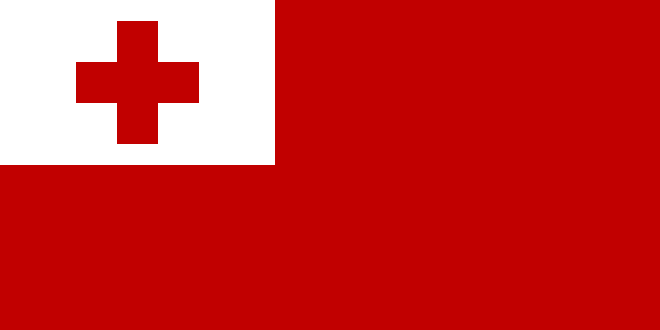
Tonga at a glance
- Capital
- Nuku'alofa
- Quiz continent
- Oceania
- Languages in reference record
- Tongaic and English
- Currency
- Paʻanga (TOP)
- Population
- 103,742 (2025, World Bank)
- Area
- 747 km²
- Coastal setting
- Not landlocked
- ISO codes
- TO / TON
- Internet country suffix
- .to
- Capital Islands
- Tongatapu
- Highest point
- Kao, 1,046 m
- Constitution
- 1875
- Constitutional Day
- 4 November
- End of the British Protectorate
- 1970
- Other island groups
- Haʻapai and Vavaʻu
Tonga Flag: Design, Meaning and History
The flag has a large red field. On the top left is a white rectangle with a red cross. This cross is completely within the corner field and does not reach over the whole flag. This distinguishes Tonga from the Nordic cross flags and from a pure white flag with a red cross.
The Factbook archive connects the cross with Christianity, white with purity and red with the blood of Christ. The symbolism is thus religious and can not only be explained from the sea situation of the country. In the quiz, the large red areas and the small white-red cross field help more than a mere comparison with other red national flags.
Capital: Nuku'alofa
Nuku’alofa is located on the north coast of Tongatapu, the island with the political center of the kingdom. The name is usually associated with Tongaic terms for place or home and love. The capital is port city and administrative centre, but not itself the name of the entire island group.
Tongatapu is located in the southern part of the national territory. The more northern groups Haʻapai and Vavaʻu have their own islands and capitals. Anyone who only looks at the capital island therefore underestimates the distances within the country. Connections across the sea are essential for the cohesion of such an island state and have a different meaning than roads in a contiguous landlocked state.
Practise this capital →Tonga: Geography, History and Culture
Tonga includes shallow coral limestone islands and volcanic islands. A western chain is of volcanic origin, while eastern islands are often made of upscale coral lime. The Kao reaches 1,046 meters. This geological division explains why flat islands and steep volcanic cones can be found in the same territory. The situation in the active Pacific region also entails natural hazards.
The settlement dates back about three millennia and belongs to the history of the Polynesian spread in the Pacific. Tongaic is a Polynesian language, English also plays an important role. Tonga’s historical networks of domination temporarily extended far beyond today’s borders. Island distances did not necessarily mean cultural isolation; seafaring connected communities across large seas.
The constitution of the kingdom dates back to 1875. In 1900, Tonga entered into a British protectorate relationship but retained his native monarchy. In 1970, it regained complete control of its external affairs. This story differs from a simple replacement of all local institutions by colonial administration. Constitution Day on November 4 commemorates an older state tradition.
Ancient capitals
The ancient capitals of the kingdom are on Tonga’s UNESCO list of proposals. Such a proposal is not yet a World Heritage entry. Nevertheless, he draws attention to historical political centers beyond today’s Nuku’alofa.
Lapita locations
Archaeological sites of Lapita ceramics are also listed on the list of proposals. They are related to early settlement and Pacific connections. Tonga thus possesses an archaeological heritage that dates back far before the modern monarchy and its constitution.
Volcano and limestone
The different types of islands are a particularly clear geographical feature. Flat Tongatapu landscapes and the high volcano Kao belong to the same state. This refutes the idea that all Pacific island states are built exclusively from low coral atolls.
Explore neighbouring and related places
 Australia
 Federated States of Micronesia
 Fiji
 Kiribati
 Marshall Islands
 Nauru
What did you discover?
Sources and image credits
This English article draws on the institutional sources listed below. Figures and memberships retain their stated reference dates.
Source record: 2 November 2026. A translation does not change the reference date of a figure or membership list.
- github.com/factbook/factbook.json/blob/144d6977b2b01ac1cbd220de754c0a005616760b/australia-oceania/tn.json
- data.worldbank.org/indicator/SP.POP.TOTL
- whc.unesco.org/en/statesparties/to
- github.com/mledoze/countries