Sudan Flag, Capital and Country Facts
Sudan lies in northeastern Africa between the Sahara, the Nile and the Red Sea. Khartoum is the capital at the confluence of the White and Blue Niles. The red-white-black flag with a green triangle belongs to the pan-Arabic symbol world. Since 2023, a serious war has shaped living conditions; historical geography and the current humanitarian situation must therefore be taken into account together.
Test your knowledge →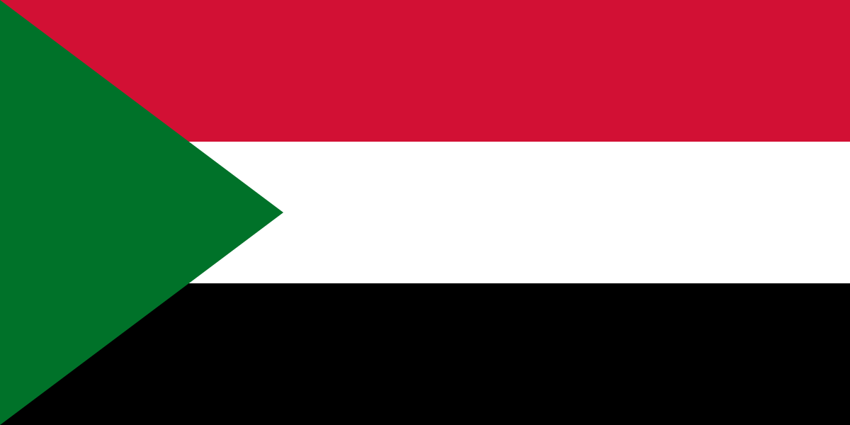
Sudan at a glance
- Capital
- Khartoum
- Quiz continent
- Africa
- Languages in reference record
- Arabic and English; also, among others, Nubian languages, Bedscha and Fur
- Currency
- Sudanese pound (SDG)
- Population
- 51,662,147 (2025, World Bank)
- Area
- 1,886,068 km²
- Coastal setting
- Not landlocked
- ISO codes
- SD / SDN
- Internet country suffix
- .sd
- Confluence of Khartoum
- White and Blue Nile
- Neighboring country since 2011
- Independent South Sudan
- Coastal Sea
- Red Sea
- Western Mountains
- Jebel Marra
- Historical Empire
- Kush
- Independence
- 1 January 1956
Sudan Flag: Design, Meaning and History
Three horizontal stripes in red, white and black are superimposed on the mast by a green triangle. There is no star or coat of arms. The order of the stripes is crucial, as is the green triangle shape. It distinguishes Sudan from Palestine’s black upper stripe and red mast triangle.
The current flag was introduced in 1970 and uses the pan-Arabic colors. In the traditional interpretation, red stands for the struggle for freedom, white for peace, black for the population and green for Islam and agriculture, among other things. The motif thus belongs to a regional symbolic tradition, but is not identical to the flags of other Arab states.
Capital: Khartoum
Khartoum lies at the confluence of the Blue and White Niles; north of it, the unified Nile flows further into Egypt. The location is the main geographical feature of the capital. Together with Omdurman and Khartoum-Nord, it forms a coherent urban space in which bridges and river banks shape the connections between the individual parts.
The war since April 2023 has hit the greater area hard and changed administrative procedures and the supply of the population. The capital of Khartoum must therefore not be read as a description of an undisturbed government and everyday operation. UN sources from 2026 report return movements, significant damage and limited basic services; actual conditions differ between places and times.
Practise this capital →Sudan: Geography, History and Culture
In the north, dry desert landscapes dominate, while to the south, more precipitation-affected spaces follow. The Nile forms a central water and settlement axis. In the west rises the Darfur mountains with the Jebel Marra, in the east the state has a coast on the Red Sea. National nature thus encompasses more than the familiar picture of desert and pyramids.
The historical kingdoms of Kush left significant sites in the Nile Valley. Meroë and the Gebel Barkal show an independent Nubian history in close connection with, but not complete equivalence with, ancient Egypt. Further east, the Sanganeb and Dungonab Bay Protected Areas preserve marine ecosystems. Cultural and natural heritage are thus located in different parts of the country and have different protection needs.
Arabic and English are used alongside Nubian languages, Bedscha, Fur and other languages. Linguistic diversity corresponds to a long history of regional connections. Since the independence of South Sudan in 2011, Sudan and South Sudan are two independent states. The current war has caused millions of displacements and serious humanitarian hardship; historical population or economic data from the archive do not reliably describe this dynamic situation.
Meroële
The archaeological sites became World Heritage Sites in 2011. The pyramids and other remains open up the history of the Kush Kingdom and expand the view beyond Egypt.
Gebel Barkal
The Gebel Barkal and the sites of the Napata region have been on the World Heritage List since 2003. They form another historical focal point along the Nile.
Natural heritage of the Red Sea
Sanganeb and Dungonab Bay with Mukkawar became World Heritage sites in 2016. The entry shows the importance of Sudanese seas alongside the better known inland landscapes.
Explore neighbouring and related places
 Central African Republic
 Chad
 Egypt
 Eritrea
 Ethiopia
 Libya
What did you discover?
Sources and image credits
This English article draws on the institutional sources listed below. Figures and memberships retain their stated reference dates.
Source record: 2 November 2026. A translation does not change the reference date of a figure or membership list.
- github.com/factbook/factbook.json/blob/144d6977b2b01ac1cbd220de754c0a005616760b/africa/su.json
- data.worldbank.org/indicator/SP.POP.TOTL
- whc.unesco.org/en/statesparties/sd/
- un.org/en/spotlight-on-sudan/background
- dtm.iom.int/reports/sudan-three-years-conflict-and-displacement
- github.com/mledoze/countries