Egypt Flag, Capital and Country Facts
Egypt connects North Africa with the eastern Mediterranean and via the Sinai Peninsula with Asia. The Nile forms the decisive settlement and agricultural corridor in a predominantly dry country. Cairo stands in the quiz as the capital; the flag bears the golden eagle of Saladin and belongs to the family of Arab red-white-black tricolors.
Test your knowledge →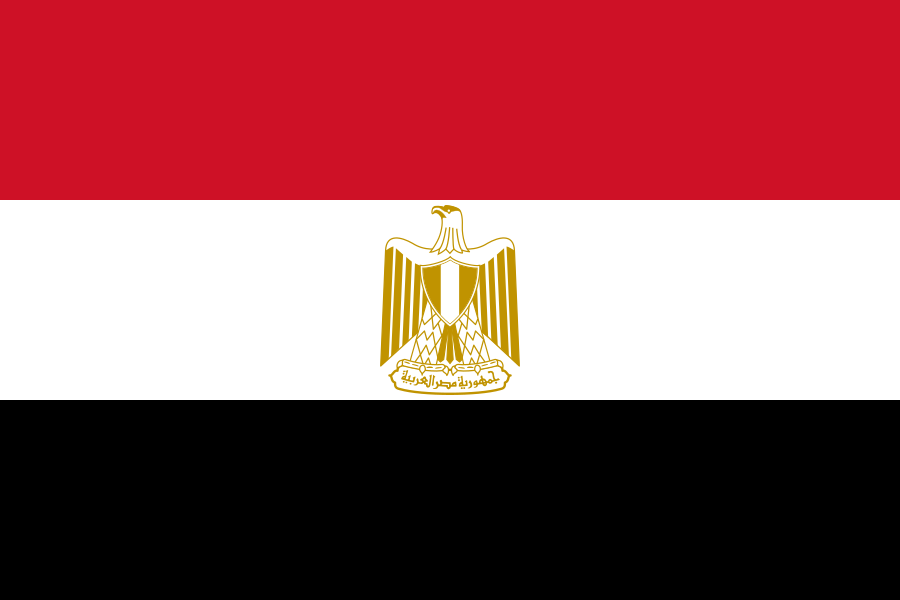
Egypt at a glance
- Capital
- Cairo
- Quiz continent
- Africa
- Languages in reference record
- Arabic
- Currency
- Egyptian pound (EGP)
- Population
- 118,365,995 (2025, World Bank)
- Area
- 1,002,450 km²
- Coastal setting
- Not landlocked
- ISO codes
- EG / EGY
- Internet country suffix
- .eg, .مصر
- Characteristic river
- Nile
- Important channel
- Suez Canal
- Highest point
- Katharinenberg, 2.629 m
- Peninsula in Asia
- Sinai
- Deep basin
- Kattara sink
- Natural World Heritage
- Wadi al-Hitan
Egypt Flag: Design, Meaning and History
Three equally high horizontal stripes are in the order of red, white and black. In the white middle strip lies a golden eagle with shield and Arabic scroll. This emblem is the most important detail to distinguish Egypt’s flag from other Arabian tricolors with similar colors.
The colors are in the tradition of the Arab liberation flags of the 20th century. The eagle is called the eagle of Saladin and combines the modern state symbol with a historical rule tradition. The current design dates back to 1984. The eagle is especially important for the quiz; a white field without an emblem, for example, would rather fit Yemen.
Capital: Cairo
Cairo lies on the Nile near the transition from the narrow river valley to the wide delta. This position connects Upper Egypt with the densely populated areas towards the Mediterranean Sea. The capital is at the same time a central transport hub and a historical urban space. Protected as a World Heritage Site, historic Cairo makes it clear that the city’s history extends far beyond modern government buildings.
The capital issue will be supplemented by the construction of a new administrative centre east of Cairo. The quiz leads Cairo as the capital; the relocation of individual ministries can be distinguished conceptually from this. In learning, therefore, not every message about new administrative buildings should be treated as an automatic change of the capital name. The greater Cairo area remains crucial for spatial classification.
Practise this capital →Egypt: Geography, History and Culture
A large part of the land area consists of desert plateaus. In between, the Nile with its valley and delta forms a narrow but particularly important habitat. The contrast between dense settlement on the waterfront and vast arid areas explains why area data alone says little about the distribution of population and agriculture. Oases form further spatially separated settlement spaces.
The Sinai Peninsula lies east of the Suez Canal and connects Egypt geographically with Asia. According to the Factbook archive, Katharinenberg reaches 2,629 meters there. The canal connects the Mediterranean Sea and the Red Sea and is one of the country’s defining transport routes. Egypt’s location thus affects both along the Nile from south to north and between two sea spaces.
The well-known pyramids belong to the history of ancient Egypt, but form only a part of the cultural heritage. The UNESCO list also includes the Christian Abu Mena, the area of the Catherine Monastery and the historical Islamic Cairo. This comparison shows different religious and political epochs. Natural history is also represented: Wadi al-Hitan preserves fossils of early whales in today's desert landscape.
Memphis and the Pyramid Fields
The World Heritage Site extends from Giza to Dahschur. It connects several archaeological areas and should therefore not be reduced to a single pyramid.
Nubian monuments
The monuments between Abu Simbel and Philae have been on the World Heritage List since 1979. They expand the geographical view from the delta to the south of the country.
Wadi al-Hitan
The “Valley of the Whales” became a natural world heritage site in 2005. It creates a particularly vivid connection between Earth's history and a landscape that today seems far removed from the image of a marine habitat.
Explore neighbouring and related places
 Israel
 Libya
 Palestine
 Sudan
What did you discover?
Sources and image credits
This English article draws on the institutional sources listed below. Figures and memberships retain their stated reference dates.
Source record: 2 November 2026. A translation does not change the reference date of a figure or membership list.
- github.com/factbook/factbook.json/blob/144d6977b2b01ac1cbd220de754c0a005616760b/africa/eg.json
- data.worldbank.org/indicator/SP.POP.TOTL
- whc.unesco.org/en/statesparties/eg/
- github.com/mledoze/countries