Eritrea Flag, Capital and Country Facts
Eritrea connects the highlands of the Horn of Africa with a long coastline on the Red Sea. There are considerable differences in altitude and climate between the high-altitude capital Asmara and the coastal towns. The territory also includes islands of the Dahlak archipelago. The flag captures this connection between land and sea with green, red and blue triangles.
Test your knowledge →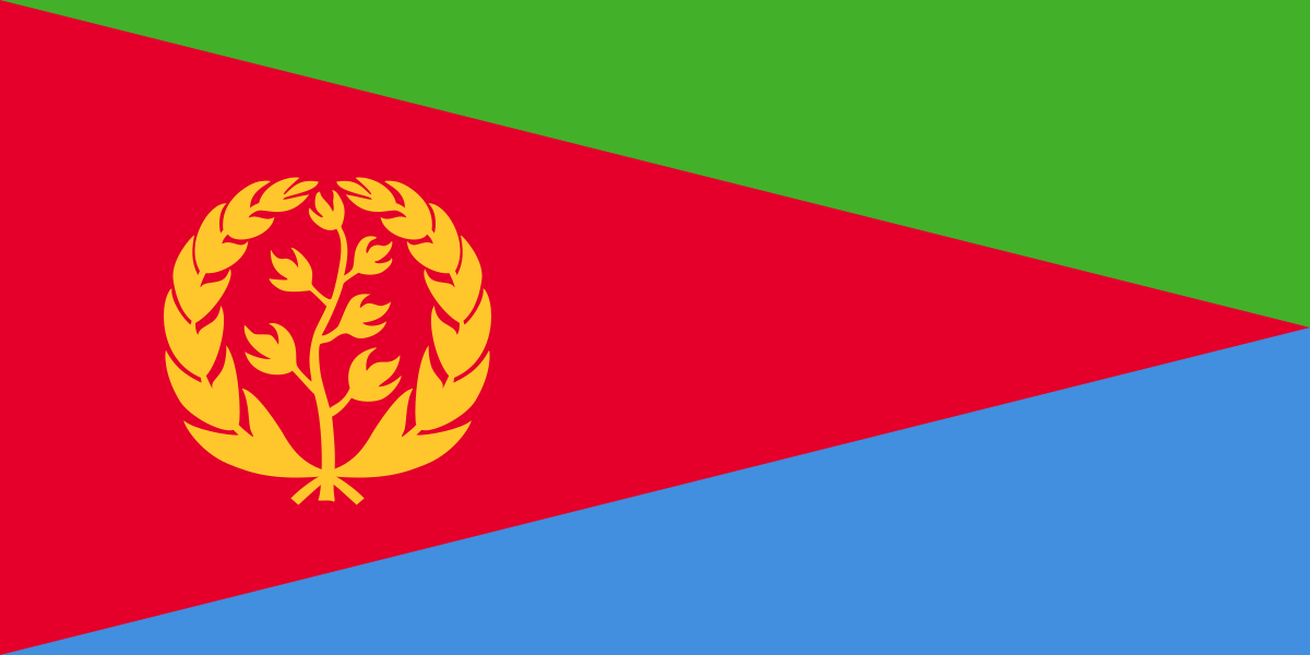
Eritrea at a glance
- Capital
- Asmara
- Quiz continent
- Africa
- Languages in reference record
- Common languages: Tigrinya, Tigre, Arabic, Afar and others; English as a working language
- Currency
- Eritrean Nakfa (ERN)
- Population
- 3,607,003 (2025, World Bank)
- Area
- 117,600 km²
- Coastal setting
- Not landlocked
- ISO codes
- ER / ERI
- Internet country suffix
- .er
- Highest mountain
- Soira, 3,018 m
- Sea
- Red Sea
- Island group
- Dahlak archipelago
- Important port
- Massawa
- National holiday
- 24 May
- Internationally recognised independence
- 1993
Eritrea Flag: Design, Meaning and History
A large red triangle extends from the left edge to the center of the right flag edge. Above that, a green triangle remains, including a blue triangle. In the wide left area of the red surface stands a golden olive branch with a surrounding wreath. The flag thus does not use ordinary horizontal stripes of equal width.
In the Factbook archive, green is associated with agriculture, blue with the sea and red with the struggle for independence. The olive branch belongs to an older Eritrean symbol tradition. The oblique lines make the motif recognizable even without readable font. A single color alone, on the other hand, would be of little help because many African states use similar hues.
Capital: Asmara
Asmara is located on a high plateau more than 2,000 meters above the sea. As a result, their climate differs significantly from the hot coastal lowlands. The capital is not a port on the Red Sea. For sea access, Massawa and Assab are particularly important names, while Asmara is the political and administrative center in the highlands.
UNESCO has listed Asmara as a modernist African city on the World Heritage List since 2017. Its cityscape was created substantially during the Italian colonial period and combines urban planning with buildings of early modernity. The appreciation of architecture also requires historical classification: the colonial design was part of a system of political domination and social inequality.
Practise this capital →Eritrea: Geography, History and Culture
The highlands fall east steeply to the coastal plain. Further south are dry landscapes of the Danakil region; in the west, the altitudes merge into lower terrain. According to the Factbook archive, the Soira reaches 3,018 meters. These high altitude differences explain why national averages do not adequately reflect the local climate.
The population speaks several Semitic and Cushit languages as well as other languages. Tigrinya and Tigre are not the same language despite similar names. A short language list should therefore be understood as a selection. The cultural and religious connections extend to the Ethiopian highlands as well as the Red Sea and neighboring lowland areas.
May 24 commemorates the independence achieved in 1991; internationally recognized statehood followed in a referendum in 1993. These two years describe different steps. The situation on major shipping lanes creates a maritime dimension, while water scarcity and unequally distributed rainfall shape the country. In order to classify economic data, archival data with a predominantly 2025 reference are expressly used here, no current government data.
Modernist capital
Asmara became a UNESCO World Heritage Site in 2017. The protection concerns a coherent urban ensemble and not just a single eye-catching building.
Dahlak archipelago
Off the coast is a group of islands in the Red Sea. As a result, Eritrea’s territory includes not only the highlands and the coastal plain but also a maritime island world.
Short distance altitudes
Between Asmara and the coast, relief and climate change greatly. The location of the capital explains this contrast better than a mere indication of areas.
Explore neighbouring and related places
 Djibouti
 Ethiopia
 Sudan
What did you discover?
Sources and image credits
This English article draws on the institutional sources listed below. Figures and memberships retain their stated reference dates.
Source record: 2 November 2026. A translation does not change the reference date of a figure or membership list.
- github.com/factbook/factbook.json/blob/144d6977b2b01ac1cbd220de754c0a005616760b/africa/er.json
- data.worldbank.org/indicator/SP.POP.TOTL
- whc.unesco.org/en/list/1550
- github.com/mledoze/countries