Central African Republic Flag, Capital and Country Facts
The Central African Republic lies in the interior of Africa between savannahs and tropical forest. Even the name of the country refers to this internal situation. However, the capital Bangui is not located in the center of the country, but on the southern border at Ubangi. The flag is conspicuous by four transverse stripes, which are cut through a red longitudinal strip.
Test your knowledge →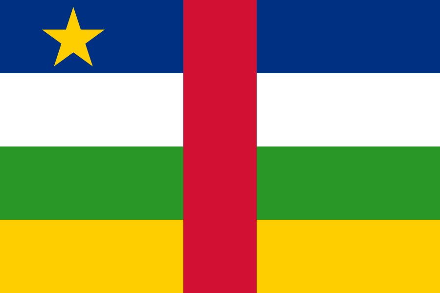
Central African Republic at a glance
- Capital
- Bangui
- Quiz continent
- Africa
- Languages in reference record
- Sango and French
- Currency
- Central African CFA franc (XAF)
- Population
- 5,513,282 (2025, World Bank)
- Area
- 622,984 km²
- Coastal setting
- Landlocked
- ISO codes
- CF / CAF
- Internet country suffix
- .cf
- Important river
- Ubangi,
- Highest point
- Mont Ngaoui, about 1,410 m
- Independence
- 13 August 1960
- Natural World Heritage
- Sangha Trinational
- Savannah Sanctuary
- Manovo-Gounda St Floris
- Former territorial name
- Ubangi shari
Central African Republic Flag: Design, Meaning and History
From top to bottom, the flag shows blue, white, green and yellow. A uniformly wide red stripe runs perpendicularly through the center of all four color fields. On the upper left is a yellow five-pointed star in the blue field. This superposition of vertical and horizontal elements makes the motif particularly recognizable under African national flags.
The design combines colors that are also known from the French tricolor and pan-African flags. The factbook archive of 2025 describes red as a reminder of the struggle for independence; other interpretations mention peace, hope and future. For recognition, however, the concrete arrangement is more reliable than a single, supposedly universal color explanation.
Capital: Bangui
Bangui is located on Ubangi, which forms part of the border with the Democratic Republic of Congo. The capital is thus at the same time a river and border location. Beyond the water lies another territory. The river name and the former colonial area name Ubangi-Shari show how important the large watercourses were for historical spatial orientation.
In the UNESCO country profile appears a proposed cultural landscape, which summarizes hills, plains, Ubangi and colonial buildings of Bangui. This underscores the connection between terrain, waterway and city history. This entry is on the list of proposals; it is not an already registered World Heritage Site. The country’s recognized World Heritage sites, on the other hand, are natural areas outside the capital.
Practise this capital →Central African Republic: Geography, History and Culture
The north is more strongly characterized by savannahs and seasonal drought, the southwest by wet forest landscapes. At the same time, the country lies between the catchment areas of the Congo and Lake Chad. The internal situation therefore does not mean uniform water conditions. Rivers can connect landscapes without providing a direct and year-round easy traffic route to the sea.
Sango is an important common language of the country; French also has an official status. In addition, many other languages are spoken. Linguistic diversity fits into a large inland area, whose regions are linked to different neighbouring landscapes. The individual name of the country must therefore not be equated with a single local culture or a uniform everyday language.
Both savannahs and rainforests are important for nature conservation. The Manovo-Gounda St. Floris National Park and the cross-border World Heritage Site Sangha Trinational represent different habitats. The latter connects protected areas in the Central African Republic, Cameroon and the Republic of Congo. Ecological relationships extend beyond state borders, while administration and state responsibilities remain separate.
Two natural heritage sites
Manovo-Gounda St. Floris was registered in 1988, Sangha Trinational 2012. UNESCO ranks both in the category Natural Heritage.
A river as a border
The Ubangi characterizes Bangui's situation. Those who locate the capital on the river also recognize the connection to the Congo basin and the southern border.
Forests across borders
Sangha Trinational is a joint protected area system of three countries. The name thus stands for cooperation and not for a single national park.
Explore neighbouring and related places
 Cameroon
 Chad
 Democratic Republic of the Congo
 Republic of the Congo
 South Sudan
 Sudan
What did you discover?
Sources and image credits
This English article draws on the institutional sources listed below. Figures and memberships retain their stated reference dates.
Source record: 2 November 2026. A translation does not change the reference date of a figure or membership list.
- github.com/factbook/factbook.json/blob/144d6977b2b01ac1cbd220de754c0a005616760b/africa/ct.json
- data.worldbank.org/indicator/SP.POP.TOTL
- whc.unesco.org/en/statesparties/cf
- github.com/mledoze/countries