Chad Flag, Capital and Country Facts
Chad lies in the interior of Africa and extends from the Sahara via the Sahel to more southern savannah landscapes. Lake Chad is located on the southwestern edge of the country. Its blue-yellow-red flag has no coat of arms and is so similar to the Romanian flag that the distinction requires particularly careful looking.
Test your knowledge →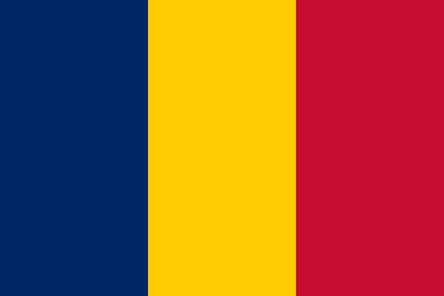
Chad at a glance
- Capital
- N'Djamena
- Quiz continent
- Africa
- Languages in reference record
- Arabic and French; numerous other languages
- Currency
- Central African CFA franc (XAF)
- Population
- 21,003,705 (2025, World Bank)
- Area
- 1,284,000 km²
- Coastal setting
- Landlocked
- ISO codes
- TD / TCD
- Internet country suffix
- .td
- Prominent volcano
- Emi Koussi in the Tibesti
- Mountains in the north
- Tibesti
- The River of the Capital
- Chari
- Former capital name
- Fort-Lamy
- Independence
- 11 August 1960
- Natural World Heritage
- Lakes of Ounianga
Chad Flag: Design, Meaning and History
Three equally wide vertical stripes form the flag: dark blue on the pole, yellow in the middle and red on the fly edge. Stars or other additional characters are missing. The flag of Romania shall have the same basic structure and the same colour order. Chad usually uses a darker shade of blue; with small or differently rendered images, the difference can be difficult to see.
The factbook archive from 2025 describes a combination of French and pan-African colors. Blue is associated with heaven and hope, yellow with sun and desert, and red with unity and sacrifice. For the quiz, an important limit must be observed: a changed image display or screen brightness can affect color shades. The comparison remains more difficult than with flags with different coats of arms.
Capital: N'Djamena
N’Djamena is located in the southwest on the Chari near the confluence with the Logone. The capital is located directly on the border with Cameroon. Their river and border position explains part of their importance for trade. At the same time, it is far from the high mountain ranges of the northern territory.
The city was called Fort-Lamy during the French colonial period and received the name N’Djamena in 1973. Old maps and historical texts can therefore use a different designation without meaning another city. The change of name is a good example of why geographical information also needs a temporal classification, while river location and border proximity are much more stable.
Practise this capital →Chad: Geography, History and Culture
The north includes Saharan areas and the Tibesti Mountains. To the south follow Sahel and more seasonal rainy savannahs. This large north-south range leads to very different living conditions. Lake Chad is part of an inland drainless basin. Its extent varies with precipitation and inflows, which is why an undated individual number of surfaces can be particularly misleading.
Arabic and French are official languages; there are also numerous local languages and regional traditions. The state became independent of France in 1960. Today’s territorial unity includes various historical contact zones between the Sahara, Sahel and Central African landscapes. A cultural description should therefore take this spatial diversity into account and not derive it from the capital alone.
The Ounianga lakes became a UNESCO natural heritage site in 2012. The Ennedi Massif has been inscribed as a mixed cultural and natural site since 2016. Rock formations, waterholes and rock art show different dimensions of the same landscape. They complement the image of Lake Chad with northern spaces and make it clear that even the Sahara is not a completely waterless and history-free area.
Almost the same flags
Chad and Romania use blue-yellow red without emblem. The usual darker blue shade of Chad is a particularly subtle difference.
Lakes in the Sahara
Ounianga is a UNESCO natural heritage site. The lakes show that a desert region can also contain special water landscapes locally.
A Historic Town Name
Fort-Lamy refers to today's N'Djamena in older sources. Since 1973, the capital bears its current name.
Explore neighbouring and related places
 Cameroon
 Central African Republic
 Libya
 Niger
 Nigeria
 Sudan
What did you discover?
Sources and image credits
This English article draws on the institutional sources listed below. Figures and memberships retain their stated reference dates.
Source record: 2 November 2026. A translation does not change the reference date of a figure or membership list.
- github.com/factbook/factbook.json/blob/144d6977b2b01ac1cbd220de754c0a005616760b/africa/cd.json
- data.worldbank.org/indicator/SP.POP.TOTL
- whc.unesco.org/en/statesparties/td
- github.com/mledoze/countries