Libya Flag, Capital and Country Facts
Libya lies on the Mediterranean Sea and reaches far into the Sahara. A large part of the settlements is concentrated on the coast, while the interior is characterized by desert spaces and oases. The capital Tripoli is in the west. Roman ruined towns and oasis architecture show different historical links between the Mediterranean, North Africa and Trans-Saharan routes.
Test your knowledge →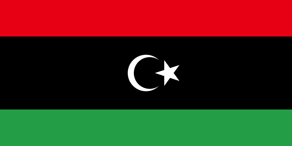
Libya at a glance
- Capital
- Tripoli
- Quiz continent
- Africa
- Languages in reference record
- Arabic; also Tamazight varieties and other languages
- Currency
- Libyan Dinar (LYD)
- Population
- 7,458,555 (2025, World Bank)
- Area
- 1,759,540 km²
- Coastal setting
- Not landlocked
- ISO codes
- LY / LBY
- Internet country suffix
- .ly
- Independence
- 24 December 1951
- Highest point
- Bikku Bitti, 2,267 m
- Sea
- Mediterranean Sea
- Greater desert
- Sahara
- Ancient site
- Leptis Magna
- Another big city
- Benghazi
Libya Flag: Design, Meaning and History
The flag consists of a red upper, a black middle stripe twice as high and a green lower stripe. In the black field stand a white crescent moon and a white five-pointed star. The broad black band distinguishes them from evenly striped tricolors; the crescent is not in a lateral triangle.
The design dates back to the Kingdom of Libya in 1951 and was reintroduced in 2011. Previously, a single-color green flag had been used during the Gaddafi period. Red, black and green are historically associated with the large parts of the country; the crescent moon and star have an Islamic reference. The tricolor shown here is therefore to be explicitly distinguished from the former green single-color flag.
Capital: Tripoli
Tripoli, Arabic Tarabulus, is located on the Mediterranean coast in the northwest of the country. The port and the location in the Tripolitan region explain its importance as a commercial and administrative center. The capital should not be confused with the Tripoli of the same name in Lebanon: both places have similar historical names, but are located in different states.
Benghazi is another important center in the east. Due to the political conflicts after 2011, institutional responsibilities and actual administration can be divided into several places. The quiz capital remains Tripoli. A geographical capital statement is thus not a statement that all power relations in the country are uniform or permanently concentrated in a single place.
Practise this capital →Libya: Geography, History and Culture
The Mediterranean coast forms a narrow transition to the vast Sahara. In the northeast lies the higher area of Jabal al-Achdar, while in the interior there are sand and rock deserts as well as oases. According to the Factbook archive, the Bikku Bitti reaches 2,267 meters. Libya is therefore, despite large desert areas, neither continuously flat nor scenically uniform everywhere.
Ancient coastal cities show the integration into Phoenician, Greek and Roman networks. Leptis Magna east of Tripoli is one of the great archaeological sites of the Mediterranean and has been on the UNESCO World Heritage List since 1982. The preserved urban complexes refer to trade, political power and urban life well before the modern oil state.
Libya became independent in 1951. Oil later shaped the economy, transport routes and the supply of cities. At the same time, water remains a fundamental limit in the very dry land; oases and fossil groundwater supplies perform different tasks than regularly fed river systems. The political fractures of recent history require dated sources. The archived factbook therefore does not include current government offices or changeable security information.
Leptis Magna
The ancient city has been a UNESCO World Heritage site since 1982. Its monuments make the Roman epoch on the North African coast visible.
Coast and desert
Dense coastal settlements face a vast sparsely populated interior. Water availability and accessibility explain this contrast better than the land area alone.
Repeated flag
The red-black-green design ties in with 1951. Their reuse since 2011 combines a recent political break with an older state tradition.
Explore neighbouring and related places
 Algeria
 Chad
 Egypt
 Niger
 Sudan
 Tunisia
What did you discover?
Sources and image credits
This English article draws on the institutional sources listed below. Figures and memberships retain their stated reference dates.
Source record: 2 November 2026. A translation does not change the reference date of a figure or membership list.
- github.com/factbook/factbook.json/blob/144d6977b2b01ac1cbd220de754c0a005616760b/africa/ly.json
- data.worldbank.org/indicator/SP.POP.TOTL
- whc.unesco.org/en/list/183
- github.com/mledoze/countries