St. Vincent & Grenadines Flag, Capital and Country Facts
Saint Vincent and the Grenadines is located in the southern part of the Lesser Antilles. The state connects the larger volcanic island of St. Vincent with a chain of smaller islands. Its flag shows three green diamonds on golden yellow. They form a V and are thus at the same time graphic symbol and reference to the name Vincent.
Test your knowledge →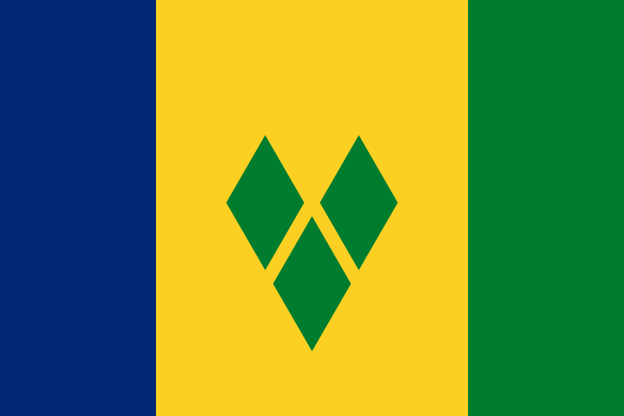
St. Vincent & Grenadines at a glance
- Capital
- Kingstown
- Quiz continent
- North America
- Languages in reference record
- English; also English-based Vincentian Creole
- Currency
- Eastern Caribbean Dollar (XCD)
- Population
- 99,924 (2025, World Bank)
- Area
- 389 km²
- Coastal setting
- Not landlocked
- ISO codes
- VC / VCT
- Internet country suffix
- .vc
- Main Island
- Saint Vincent
- Highest mountain
- La Soufrière, 1,234 m
- Well-known Grenadines Island
- Bequia
- Another island
- Mustique
- Independence
- 27 October 1979
- Flag forms
- Three green diamonds in a V-arrangement
St. Vincent & Grenadines Flag: Design, Meaning and History
Three vertical color fields show blue on the left, golden yellow in the wider middle and green on the right. The golden area is twice as wide as any outer band. There are three green diamonds in it: two further up, one below. Together they form a V. A coat of arms, a star or a writing are not part of this motif.
Blue is associated with sea and sky, yellow with sand and green with vegetation. The diamonds refer in the traditional declaration to the islands as gemstones of the Antilles. This pictorial interpretation is not an indication of actual diamond occurrences. For the determination of the flag, the V-arrangement of the three geometric shapes is especially important.
Capital: Kingstown
Kingstown is located on the southwest coast of St. Vincent. The capital city forms a political and economic focus of the main island. Port and coastal location are important for connections to the smaller islands. The name of the country mentions two geographical components, but the capital is not on a small Grenadines island, but on the larger northern main island.
The urban coastal center lies in a different landscape than the high northern part of St. Vincent. There, the volcano La Soufrière characterizes the island. This comparison helps to understand the unequal distribution of settlement spaces. An island can include on a small map area at the same time a harbour space, wooded slopes and an active volcanic area.
Practise this capital →St. Vincent & Grenadines: Geography, History and Culture
The Grenadines run south of St. Vincent towards Grenada. Not the entire geographical island chain belongs to Saint Vincent and the Grenadines; its southern part belongs to the state of Grenada. The names are therefore easily confused. The archipelago and the state border describe different spatial units that do not completely coincide.
English is the official language, while an English-based Creole is common in everyday life. The history of the country includes indigenous population, European colonial rule, enslavement and resistance. The state became independent of Britain in 1979. Such historical contexts explain today's language and state designations without reducing the people of the different islands to a single cultural way of life.
The UNESCO country profile lists rock art, the Grenadines Island Group and La Soufrière National Park as proposed sites. None of these proposals is therefore automatically already a World Heritage Site. However, the three themes show the range of possible heritage: archaeological evidence, marine and island landscapes as well as volcanic nature. Especially for a small state, this view beyond the capital is worthwhile.
Three green diamonds
The diamonds form a V for Vincent. Their gemstone interpretation is symbolic and does not describe a deposit.
A Divided Island Chain
The Grenadines belong politically to two states. The southern section belongs to Grenada, the northern to St. Vincent and the Grenadines.
Volcano on the main island
La Soufrière is an active volcano in the north of St. Vincent. Its landscape differs significantly from the coastal area around Kingstown.
Explore neighbouring and related places
 Antigua & Barbuda
 Bahamas
 Barbados
 Belize
 Canada
 Costa Rica
What did you discover?
Sources and image credits
This English article draws on the institutional sources listed below. Figures and memberships retain their stated reference dates.
Source record: 2 November 2026. A translation does not change the reference date of a figure or membership list.
- github.com/factbook/factbook.json/blob/144d6977b2b01ac1cbd220de754c0a005616760b/central-america-n-caribbean/vc.json
- data.worldbank.org/indicator/SP.POP.TOTL
- whc.unesco.org/en/statesparties/vc
- github.com/mledoze/countries