St. Lucia Flag, Capital and Country Facts
Saint Lucia belongs to the Lesser Antilles in the Eastern Caribbean. The mountainous island connects tropical coastal spaces with volcanic landscapes inside. Castries is the capital and port city; the two pitons in the southwest, on the other hand, are the most famous landscape signs. Its form is also found in the national flag as a stylized reference.
Test your knowledge →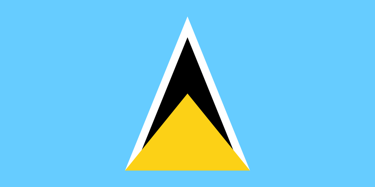
St. Lucia at a glance
- Capital
- Castries
- Quiz continent
- North America
- Languages in reference record
- English (official language); also Saint-Lucian-Creole / Kwéyòl
- Currency
- Eastern Caribbean Dollar (XCD)
- Population
- 180,149 (2025, World Bank)
- Area
- 616 km²
- Coastal setting
- Not landlocked
- ISO codes
- LC / LCA
- Internet country suffix
- .lc
- Highest mountain
- Mount Gimie, 948 m
- Well-known mountain group
- Gros Piton and Petit Piton
- Independence
- 22 February 1979
- Island group
- Small Antilles
- Neighboring island in the north
- Martinique
- UNESCO Natural Area
- Pitons Management Area
St. Lucia Flag: Design, Meaning and History
On a blue background, the flag shows a group of triangular shapes pushed into each other. A black triangle bordered narrowly white juts out over a wider yellow triangle. The shapes are in the middle and point upwards. It is precisely this clear geometric motif that distinguishes the flag from many Caribbean flags with coats of arms or stars.
Blue is associated with sea and sky, yellow with sun and prosperity. The black and white areas are related to the population composition. The triangles remind of Gros Piton and Petit Piton. The flag thus picks up recognizable natural forms, without depicting the two mountains as a natural landscape.
Capital: Castries
Castries is located on a protected bay in the northwest of the island. The port location explains the importance of the city as a transport and commercial center. The capital and the most famous natural landscape are not in the same place: If you have located Castries, you have to look further southwest to the surroundings of Soufrière for the Pitons.
The city name goes back to a French naval and colonial minister of the 18th century. This is reminiscent of the volatile French-British history of the island. The official language today is English, while the French-based Kwéyòl remains an important everyday language. The place name and language landscape thus preserve different historical influences.
Practise this capital →St. Lucia: Geography, History and Culture
St. Lucia is of volcanic origin and has a highly moving relief. Mount Gimie reaches 948 meters and is higher than both Pitons. This distinction is useful for the quiz: the most famous mountains do not have to be the highest. Coastal bays, steep slopes and humid altitudes create different habitats on a small area.
The Pitons Management Area is a UNESCO World Heritage Site. In addition to Gros Piton and Petit Piton, the protected space includes other volcanic and maritime habitats. The site is therefore not only honored for two attractive mountain silhouettes, but also because of the coherent landscape and natural space, which also includes geological processes.
The island is located between Martinique and St. Vincent. This neighborhood ranks them within the long island arc of the Lesser Antilles. Independence from Britain took place on 22 February 1979. The currency is the Eastern Caribbean dollar, which other states and regions of the region also use; a common currency does not mean a common state here.
Two famous summits
Gros Piton and Petit Piton are steep volcanic landscape signs. Their recognizability explains the triangular shapes of the flag. The highest mountain on the island, however, is the less iconic Mount Gimie, which dissolves a popular confusion.
Natural heritage of Soufrière
The UNESCO area connects the Pitons with their surroundings. Those who only look at the two peaks overlook the concept of protection of the entire landscape; coastal and marine habitats are also part of the context of this volcanic island region.
Two linguistic levels
English assumes official functions, while Kwéyòl is part of everyday life for many people. The French-based Creole language shows that today’s administrative language does not explain or replace all the historical influences of a Caribbean island society.
Explore neighbouring and related places
 Antigua & Barbuda
 Bahamas
 Barbados
 Belize
 Canada
 Costa Rica
What did you discover?
Sources and image credits
This English article draws on the institutional sources listed below. Figures and memberships retain their stated reference dates.
Source record: 2 November 2026. A translation does not change the reference date of a figure or membership list.
- github.com/factbook/factbook.json/blob/144d6977b2b01ac1cbd220de754c0a005616760b/central-america-n-caribbean/st.json
- data.worldbank.org/indicator/SP.POP.TOTL
- whc.unesco.org/en/statesparties/lc/
- github.com/mledoze/countries