St. Kitts & Nevis Flag, Capital and Country Facts
Saint Kitts and Nevis is a small Caribbean island nation with two main islands. The capital Basseterre is located on St. Kitts. Volcanic heights, coastal settlements and traces of European colonial history characterize the space. The flag connects two white stars with a black-and-yellow diagonal band and can thus be distinguished from other Caribbean flags.
Test your knowledge →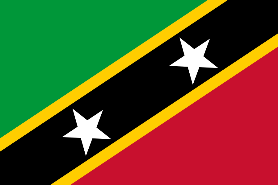
St. Kitts & Nevis at a glance
- Capital
- Basseterre
- Quiz continent
- North America
- Languages in reference record
- English (official language); also Creole language forms
- Currency
- Eastern Caribbean Dollar (XCD)
- Population
- 46,922 (2025, World Bank)
- Area
- 261 km²
- Coastal setting
- Not landlocked
- ISO codes
- KN / KNA
- Internet country suffix
- .kn
- Highest mountain
- Mount Liamuiga, 1.156 m
- Independence
- 19 September 1983
- Main town on Nevis
- Charlestown
- Island group
- Small Antilles
- Flag stars
- 2
- World Heritage
- Brimstone Hill, since 1999
St. Kitts & Nevis Flag: Design, Meaning and History
A wide black band moves from the bottom left to the top right. It has narrow yellow borders and carries two white five-pointed stars. The upper field on the hoist side is green, the lower field on the right is red. The decisive factor is therefore an upwardly directed diagonal band, not a horizontal strip pitch.
The Factbook archive combines green with fertility, red with the fight against enslavement, yellow with sunshine and black with the African heritage of the population. The two stars are referred to St. Kitts and Nevis; there are also interpretations as hope and freedom. These additional meanings do not change the clearly visible dual number.
Capital: Basseterre
Basseterre is located on the south coast of St. Kitts. The French name means “low land” and fits the location in contrast to the mountainous island interior. The fact that the capital is located on St. Kitts is important for orientation: The state consists of two main islands, but not each one carries the same central government tasks.
The city is a port and administrative center. With Charlestown, Nevis has its own important capital and a special position within the Federation. A look at both islands explains the state name better than just looking at the capital. The dividing strait is at the same time a connection and spatial boundary between the two island societies.
Practise this capital →St. Kitts & Nevis: Geography, History and Culture
Saint Kitts and Nevis belong to the island arc of the Lesser Antilles. Both islands are volcanic and tower well above sea level. Mount Liamuiga on St. Kitts reaches 1,156 meters. Coastal stripes and island interiors therefore differ greatly: In a narrow area, port towns, agricultural areas and steep forested heights are next to each other.
The colonial history includes British and French rule and rivalry. Sugar cultivation on plantations and the work of enslaved people have long shaped the economy and society. English is the official language, Creole language forms are also part of everyday life. These historical contexts provide a more concrete approach than a general description of the islands as a mere tropical holiday destination.
The state became independent from the United Kingdom on 19 September 1983. Its federal structure holds the two island parts together politically and at the same time takes into account their independence. The change from a sugarcane-dominated economy to services and tourism is part of recent history. Small area does not mean that both islands have the same historical or economic focus on all issues.
Brimstone Hill
The Brimstone Hill Fortress National Park has been a UNESCO World Heritage Site since 1999. The fortress is a testament to colonial military history. Its importance also includes the work of the African enslaved people who were involved in the construction of such facilities.
Two stars, two islands
The two white stars facilitate the assignment to the double name St. Kitts and Nevis. In the flag picture, they appear on the same black band. This is a memorable connection between the visible design and the geographical structure of the state.
Volcanic altitudes
Mount Liamuiga is located on St. Kitts and is the highest point in the country. Its altitude shows that even small Caribbean islands can have distinct mountain landscapes. The proximity of the summit and coast also characterizes precipitation, vegetation and settlement areas.
Explore neighbouring and related places
 Antigua & Barbuda
 Bahamas
 Barbados
 Belize
 Canada
 Costa Rica
What did you discover?
Sources and image credits
This English article draws on the institutional sources listed below. Figures and memberships retain their stated reference dates.
Source record: 2 November 2026. A translation does not change the reference date of a figure or membership list.
- github.com/factbook/factbook.json/blob/144d6977b2b01ac1cbd220de754c0a005616760b/central-america-n-caribbean/sc.json
- data.worldbank.org/indicator/SP.POP.TOTL
- whc.unesco.org/en/statesparties/kn
- github.com/mledoze/countries