Solomon Islands Flag, Capital and Country Facts
The Solomon Islands is an island nation in the southwestern Pacific Ocean east of Papua New Guinea. Honiara is located on Guadalcanal, an island of great importance in the history of the Second World War. The flag divides blue and green by a yellow oblique strip. Many islands, languages and sea routes shape the country more than a single contiguous settlement area.
Test your knowledge →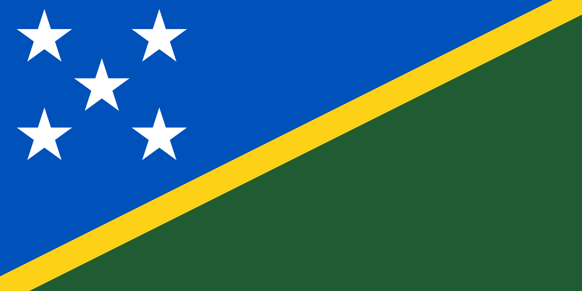
Solomon Islands at a glance
- Capital
- Honiara
- Quiz continent
- Oceania
- Languages in reference record
- English (official language); Solomon Pijin as an important linguistic language, numerous local languages
- Currency
- Solomon Islands Dollar (SBD)
- Population
- 838,645 (2025, World Bank)
- Area
- 28,896 km²
- Coastal setting
- Not landlocked
- ISO codes
- SB / SLB
- Internet country suffix
- .sb
- Capital Islands
- Guadalcanal
- Highest mountain
- Mount Popomanaseu, 2,335 m
- Independence
- 7 July 1978
- Important language of transport
- Solomon Islands pijon
- Flag stars
- 5
- Natural World Heritage
- East Rennell, since 1998
Solomon Islands Flag: Design, Meaning and History
A yellow diagonal stripe pulls from the bottom left to the top right. Above is a blue field, below a green field. In the blue area, there are five white five-pointed stars in an approximately X-shaped group. The combination of five stars and oblique yellow separation is the central distinguishing feature.
The Factbook archive combines blue with the ocean, green with the land and yellow with sunshine. The stars refer to the most important archipelagos or the structure at the time of introduction. Their number should not readily be read as the current number of all provinces; flags can preserve historical divisions.
Capital: Honiara
Honiara is located on the north coast of Guadalcanal. The capital is thus assigned to a particular island, not its own capital island. The location opens up to the sea space between Guadalcanal and neighboring islands and illustrates the importance of sea routes for the everyday life of the island state.
Guadalcanal was an important theatre of war during World War II. Honiara’s recent urban development is closely linked to that period and the transport and administrative structures that emerged afterwards. The capital can therefore be explained differently than a European residence city that has grown over centuries: its central position is essential to the history of the 20th century.
Practise this capital →Solomon Islands: Geography, History and Culture
The larger islands are often mountainous and volcanic; in addition, smaller coral islands and atolls. Mount Popomanaseu on Guadalcanal reaches 2,335 meters. The Solomon Islands therefore do not consist exclusively of flat sand islands. Relief, coasts and sea distances create different conditions for agriculture, settlements and transport within the state.
English is an official language, Solomon Pijin is an important linguistic language between people of different first languages. There are also numerous local languages. This diversity is related to the long-standing island world and its communities. It cannot be derived solely from the population: a relatively small state can have many languages and at the same time use a common interregional language of communication.
The state became independent from the United Kingdom on 7 July 1978. Its geographical island chain and territory are not completely identical, because Bougainville belongs politically to Papua New Guinea. This difference between physical archipelago and modern state border is especially important when reading maps. The UNESCO heritage of East Rennell also draws on a coral island space away from Guadalcanal.
East Rennell
East Rennell has been a UNESCO natural heritage site since 1998. It covers part of the island of Rennell and its significant natural area. The entry complements the mountainous large islands with another landscape form within the same Pacific state.
Guadalcanal
The island carries the capital and is at the same time an important place in the history of war. Both explain their international fame. But it is only a part of the Solomon Islands; other islands have their own linguistic, cultural and scenic focuses.
Pijin as a compound
Solomon Islands-Pijin enables communication across many local language boundaries. Official language and everyday language are thus different categories. This distinction is especially useful for understanding the linguistic situation of a diverse island nation.
Explore neighbouring and related places
 Australia
 Federated States of Micronesia
 Fiji
 Kiribati
 Marshall Islands
 Nauru
What did you discover?
Sources and image credits
This English article draws on the institutional sources listed below. Figures and memberships retain their stated reference dates.
Source record: 2 November 2026. A translation does not change the reference date of a figure or membership list.
- github.com/factbook/factbook.json/blob/144d6977b2b01ac1cbd220de754c0a005616760b/australia-oceania/bp.json
- data.worldbank.org/indicator/SP.POP.TOTL
- whc.unesco.org/en/statesparties/sb
- github.com/mledoze/countries