Serbia Flag, Capital and Country Facts
Serbia is located in south-eastern Europe and connects the Pannonian plains with the mountainous regions of the Balkans. Belgrade is located at the confluence of the rivers Save and Danube. The flag bears the Pan-Slavic colors red, blue and white as well as a coat of arms shifted to the mast; historical monasteries and Roman sites open up different eras of the country's history.
Test your knowledge →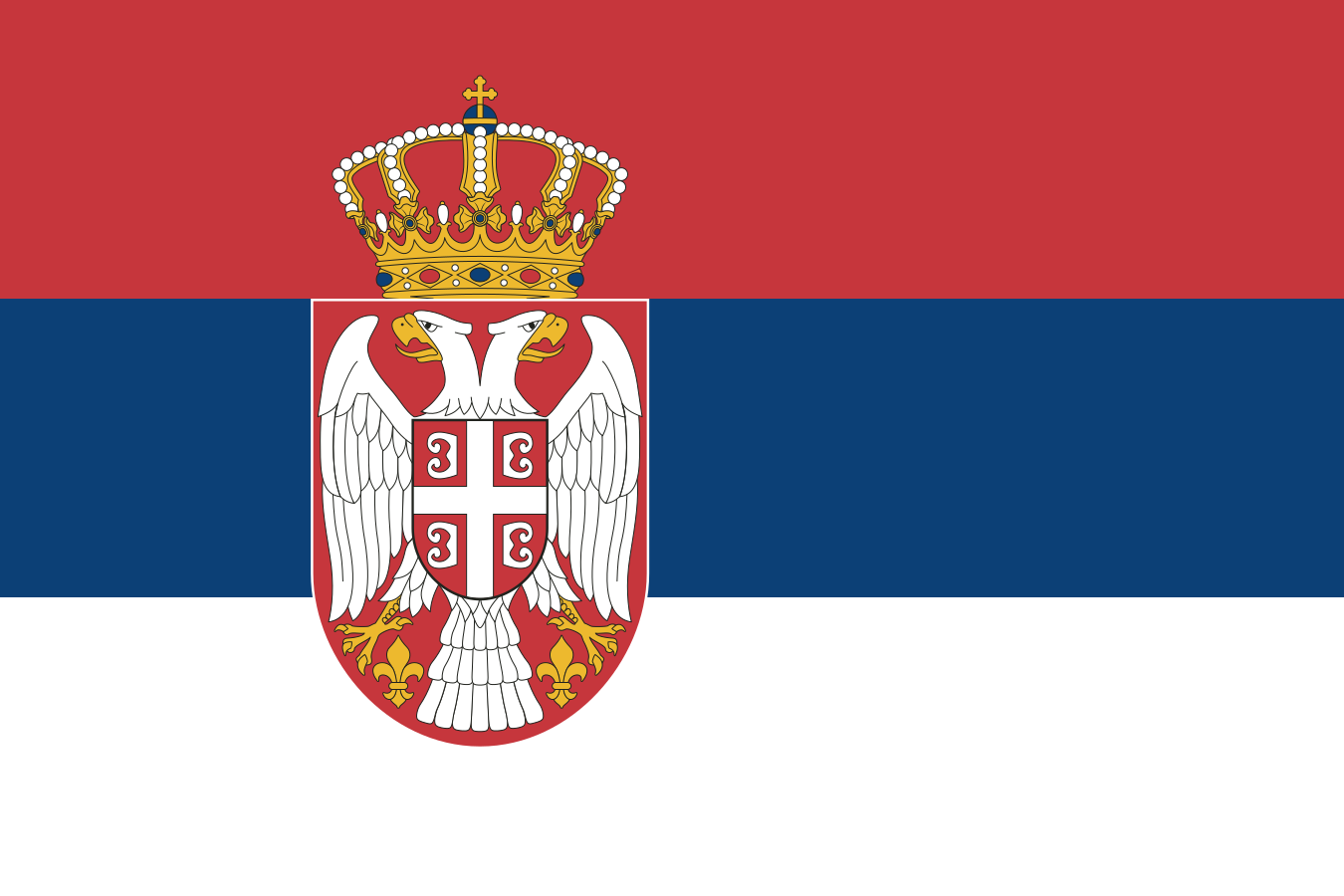
Serbia at a glance
- Capital
- Belgrade
- Quiz continent
- Europe
- Languages in reference record
- Serbian; regionally other official languages including Hungarian, Slovak, Romanian, Croatian and Russian
- Currency
- Serbian Dinar (RSD)
- Population
- 6,549,143 (2025, World Bank)
- Area
- 88,361 km²
- Coastal setting
- Landlocked
- ISO codes
- RS / SRB
- Internet country suffix
- .rs, .срб
- Capital rivers
- Save and Danube
- Northern Region
- Vojvodina
- Further Danube Centre
- Novi Sad
- Writings of Serbian
- Cyrillic and Latin
- Roman World Heritage Site
- Gamzigrad-Romuliana
- State holidays
- 15 February
Serbia Flag: Design, Meaning and History
Three equally high horizontal stripes are in red, blue and white. On the hoist side lies a crowned coat of arms with white double eagle on a red shield. On its chest appears a smaller red shield with a white cross. The position of the coat of arms and the order of the strips are particularly helpful recognition features.
Red, blue and white belong to the Pan-Slavic color tradition. The crown in the coat of arms refers to historical monarchical symbolism, but does not mean that Serbia would be a monarchy today. So the motif connects different layers of time. A simple tricolor and the state flag with coats of arms should be kept apart in the exact description, instead of every small heraldic detail to a new flag.
Capital: Belgrade
Belgrade is where the Sava River flows into the Danube. This position makes the capital a hub between major river and traffic axes. The fortress above the confluence illustrates why the place was strategically important for a long time. The Serbian name Beograd means “white city” and is associated with the bright stone of fortification.
The capital is at the same time the largest political and economic center of the country. Novi Sad on the Danube forms another important urban space in northern Vojvodina. The comparison of both cities helps to distinguish capital function and regional centers. Both are located on the Danube system, but the surrounding landscapes and historical integrations are not the same in all points.
Practise this capital →Serbia: Geography, History and Culture
To the north are the fertile plains of Vojvodina, which belong to the Pannonian region. Further south, the terrain becomes increasingly hilly and mountainous. This change affects agriculture, settlements and transport routes. The Danube connects Serbia with several Central European and Southeastern European countries; rivers are also transport routes, border areas and supra-regional landscape axes.
The Danube section at the Iron Gate shows a distinctly different type of landscape than the broad northern plains. Mountains and breakthrough stalls create bottlenecks, while shallow basins allow for larger settlement and agricultural areas. A blanket classification as a “Balkanbergland” would therefore be just as incomplete as the idea of a continuously flat Danube country. Serbia’s geographical location connects the two metropolitan areas.
Serbian is used with both Cyrillic and Latin script. In Vojvodina, other languages have regional official status. The cultural history includes medieval monasteries, Ottoman and Habsburg influences and Roman legacies. The UNESCO sites Studenica, Stari Ras and Sopoćani as well as Gamzigrad-Romuliana show different epochs instead of representing a single unchanged cultural tradition.
Studenica
The monastery has been on the World Heritage List since 1986. It is one of the most important testimonies of medieval Serbian sacred architecture.
Gamzigrad-Romuliana
The palace complex of Galerius became a World Heritage site in 2007. It opens up a Roman epoch and complements the medieval monasteries with a different historical context.
Two rivers as a city feature
Save and Danube meet in Belgrade. This confluence explains both the strategic importance of the location and its role as a transport link between different regions.
Explore neighbouring and related places
 Bosnia & Herzegovina
 Bulgaria
 Croatia
 Hungary
 North Macedonia
 Montenegro
What did you discover?
Sources and image credits
This English article draws on the institutional sources listed below. Figures and memberships retain their stated reference dates.
Source record: 2 November 2026. A translation does not change the reference date of a figure or membership list.
- github.com/factbook/factbook.json/blob/144d6977b2b01ac1cbd220de754c0a005616760b/europe/ri.json
- data.worldbank.org/indicator/SP.POP.TOTL
- whc.unesco.org/en/statesparties/rs/
- github.com/mledoze/countries