North Macedonia Flag, Capital and Country Facts
North Macedonia is located in the southern Balkans without access to the sea. Mountains, deep basins and cross-border lakes characterize the country. Its flag shows a sun whose eight rays reach to the edges. Skopje is located on the Vardar; the Ohrid region combines cultural heritage with an old and species-rich lake landscape.
Test your knowledge →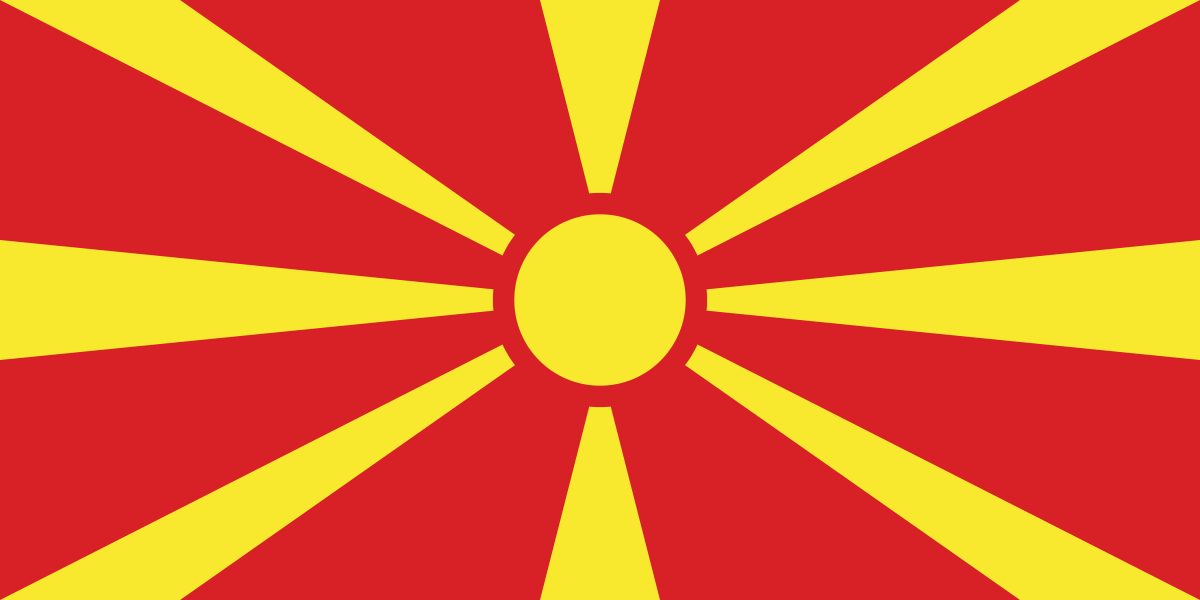
North Macedonia at a glance
- Capital
- Skopje
- Quiz continent
- Europe
- Languages in reference record
- Macedonian; Albanian with official status and other regionally recognized languages
- Currency
- Denar (MKD)
- Population
- 1,820,909 (2025, World Bank)
- Area
- 25,713 km²
- Coastal setting
- Landlocked
- ISO codes
- MK / MKD
- Internet country suffix
- .mk
- Highest mountain
- Korab, 2,764 m
- Important river
- Vardar
- Independence Day
- 8 September 1991
- Current name of the State
- Since 2019
- Great shared lake
- Ohrid lake
- Structuring earthquake
- Skopje, 1963
North Macedonia Flag: Design, Meaning and History
On a red background, there is a yellow sun disc in the middle. Eight broad yellow rays run outwards and become wider towards the edges. There are neither stars nor an additional coat of arms. The rays touch all four sides and make the entire flag a sun theme, not just a small area in the center.
The current design was adopted in 1995. It replaced an older flag with a differently shaped historical sun sign. Red and yellow belong to the national color tradition; the sun is understood as the sun of freedom. The eight-ray form used in the quiz must therefore be distinguished from historical and regional symbol variants.
Capital: Skopje
Skopje is located in the north of the country on the River Vardar. The capital occupies an important valley space, which allows connections through the mountainous interior. The river and its transport axis are thus a good geographical key: in a highly structured country, valleys bundle paths, trade and larger settlements.
The cityscape was changed by a severe earthquake in 1963 and the subsequent reconstruction. Older Ottoman-influenced areas stand alongside later architecture and recent monumental transformations. Therefore, Skopje does not have a single center that originates continuously from an epoch. The different designs document different ideas of what a capital city should look like.
Practise this capital →North Macedonia: Geography, History and Culture
North Macedonia is predominantly mountainous. The Korab on the Albanian border reaches 2,764 meters. Lake Ohrid, Prespa and Dojran are shared with neighbouring states. State borders thus also run through natural landscape areas; water resources and nature conservation cannot be limited to a single shore. The three large lakes are therefore not only inland landscapes, but also direct points of contact with neighbouring states.
Macedonian is a South Slavic language and uses Cyrillic script. Albanian also has an important official status; other minority languages are of regional importance. Linguistic diversity is relevant for administration and everyday life. It should neither disappear behind the designation of a nation state nor be reduced to a simplified comparison with two completely separate population blocs.
Independence was supported by a referendum in 1991. The current state name North Macedonia has been valid since 2019 after the agreement with Greece. Older sources may therefore contain other names. The factbook archive status of 2025 already takes into account today’s name. The country is to be distinguished from the wider geographical-historical area of Macedonia, which also includes territories of other states.
Ohrid region
UNESCO lists the natural and cultural heritage of the Ohrid region as a mixed site. The entry is shared with Albania and connects landscape with important historical buildings.
Beech forests
North Macedonia participates in the cross-border World Heritage of European beech forests. The protection concerns selected forest areas and not all beech stocks.
Vardar axis
The Vardar runs through the country and continues to Greece. Its valley explains the importance of the country as a transport area between the Balkan interior and the Aegean.
Explore neighbouring and related places
 Albania
 Bulgaria
 Greece
 Serbia
What did you discover?
Sources and image credits
This English article draws on the institutional sources listed below. Figures and memberships retain their stated reference dates.
Source record: 2 November 2026. A translation does not change the reference date of a figure or membership list.
- github.com/factbook/factbook.json/blob/144d6977b2b01ac1cbd220de754c0a005616760b/europe/mk.json
- data.worldbank.org/indicator/SP.POP.TOTL
- whc.unesco.org/en/statesparties/mk
- github.com/mledoze/countries