Croatia Flag, Capital and Country Facts
Croatia connects the plains of Save and Drau with the Dinaric Mountains and a strongly divided Adriatic coast. Many well-known coastal towns are far from the capital Zagreb. The red and white chessboard in the coat of arms is the most striking flag feature. Above it are five smaller shields that take up historical landscapes and political traditions.
Test your knowledge →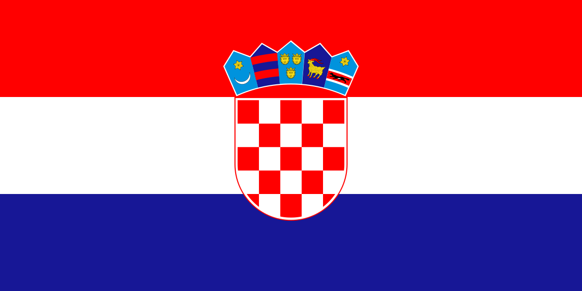
Croatia at a glance
- Capital
- Zagreb
- Quiz continent
- Europe
- Languages in reference record
- Croatian
- Currency
- Euro (EUR)
- Population
- 3,876,200 (2025, World Bank)
- Area
- 56,594 km²
- Coastal setting
- Not landlocked
- ISO codes
- HR / HRV
- Internet country suffix
- .hr
- Highest mountain
- Dinara, 1.831 m
- River near Zagreb
- Save/Sava
- Sea
- Adriatic Sea
- Peninsula
- Istria
- Natural World Heritage
- Plitvice Lakes
- Declaration of Independence
- 25 June 1991
Croatia Flag: Design, Meaning and History
Three equally wide transverse stripes form red, white and blue from top to bottom. In the middle is the Croatian coat of arms with a red-and-white shafted main shield. Above it, five small shields form a crown-like row. The coat of arms extends into several stripes and is therefore the decisive difference to other red-white-blue tricolors.
The main shield has 13 red and 12 silver fields. The five smaller shields refer to the historical coat of arms traditions of Croatia, Dubrovnik, Dalmatia, Istria and Slavonia. Red, white and blue belong to the Slavic color tradition. The chessboard pattern is particularly important for recognition; the small shields also provide a reduced heraldic map.
Capital: Zagreb
Zagreb is located in the northwest inland area near the Sava and at the foot of Medvednica. The capital is the central political and an important economic centre. Anyone who only knows Croatia from the Adriatic coast overlooks a large part of its geography. The capital is located neither in Dubrovnik nor in Split and does not have its own sea beach.
The location of Zagreb connects it more with the traffic and settlement areas of Central Europe than with the narrow Dalmatian coastal strip. At the same time, important routes lead from there to the Adriatic. The spatial tension between inland, mountains and coast explains the long country form and the different historical relations of the individual regions much better than a pure beach picture.
Practise this capital →Croatia: Geography, History and Culture
The Dinaric Mountains separate and connect coastal and inland landscapes. Karst forms, caves and water-soluble limestone play a major role. The Plitvice Lakes vividly show how water and limestone deposits form stepped lakes and waterfalls. They are located inland and belong to the natural world heritage, while many coastal sites have been recognized for their urban and building history.
Croatian is a southern Slavic language and is predominantly written in Latin script. The country belonged to Yugoslavia in the 20th century and declared its independence in 1991. However, the regional historical links are older and more diverse. Especially on the coast, Roman, medieval and Venetian imprints can be compared in different places.
Split with the Diocletian Palace and Dubrovnik's old town are on the UNESCO list. On the island of Hvar, on the other hand, the plain of Stari Grad is recognized as a cultural landscape. The comparison shows three different standards: an ancient palace in the later urban fabric, a fortified city and an agricultural space. Croatia’s cultural heritage thus encompasses more than individual monuments.
Chessboard as an identification mark
The red and white coat of arms distinguishes the flag from other Slavic tricolors. The small signs above refer to several historical regions.
Water in karst
Plitvice is a UNESCO natural heritage site. The lake landscape is located inland and complements the well-known pictures of the Adriatic coast.
Palace and City
The historic complex of Split includes the Diocletian Palace. Ancient buildings and later urban development are considered as a coherent ensemble.
Explore neighbouring and related places
 Bosnia & Herzegovina
 Hungary
 Montenegro
 Serbia
 Slovenia
What did you discover?
Sources and image credits
This English article draws on the institutional sources listed below. Figures and memberships retain their stated reference dates.
Source record: 2 November 2026. A translation does not change the reference date of a figure or membership list.
- github.com/factbook/factbook.json/blob/144d6977b2b01ac1cbd220de754c0a005616760b/europe/hr.json
- data.worldbank.org/indicator/SP.POP.TOTL
- whc.unesco.org/en/statesparties/hr
- github.com/mledoze/countries