São Tomé & Príncipe Flag, Capital and Country Facts
São Tomé and Príncipe is an island nation in the Gulf of Guinea near the equator. The two main islands are volcanic and covered by tropical vegetation. The capital São Tomé is located on the larger island. Príncipe has its own regional status and has been recognized as a UNESCO Biosphere Reserve since 2012.
Test your knowledge →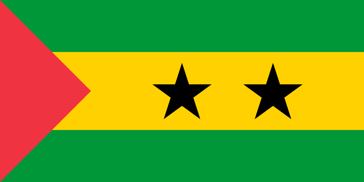
São Tomé & Príncipe at a glance
- Capital
- São Tomé
- Quiz continent
- Africa
- Languages in reference record
- Portuguese (official language); also among others Forro, Angolan and other Creole languages
- Currency
- São Toméan Dobra (STN)
- Population
- 240,254 (2025, World Bank)
- Area
- 964 km²
- Coastal setting
- Not landlocked
- ISO codes
- ST / STP
- Internet country suffix
- .st
- Highest mountain
- Pico de São Tomé, 2,024 m
- Independence
- 12 July 1975
- Biosphere Reserve
- Príncipe, since 2012
- Historical plantations
- Roças
- Important agricultural product
- Cocoa
- Position
- Gulf of Guinea, near the equator
São Tomé & Príncipe Flag: Design, Meaning and History
The flag shows three horizontal stripes in green, yellow and green, with the yellow middle stripe being twice as wide. It contains two black five-pointed stars. A red triangle extends from the mast into the cloth. Stars, broad yellow field and lateral triangle together make up the unmistakable basic pattern.
The two stars stand for São Tomé and Príncipe, the two main islands. Green refers to vegetation, yellow to cocoa and red to the struggle for independence. The colors belong to the Pan-African tradition. The flag thus combines the concrete island geography with economic history and the political emergence of the independent state.
Capital: São Tomé
São Tomé is both the name of the larger island and its capital. The city is located on the northeastern coast and forms the political center. The same name thus denotes different spatial levels; the entire country also includes Príncipe and other islands. Especially in the capital quiz this distinction between state, island and city helps.
The Portuguese name means Saint Thomas and goes back to the European name of the island. The capital developed in connection with colonial settlement and the Atlantic trade. This history is closely connected with plantation farming and enslavement; preserved buildings and place names should therefore not be considered in isolation from the social conditions of that time.
Practise this capital →São Tomé & Príncipe: Geography, History and Culture
The islands are part of a volcanic zone in the Gulf of Guinea. The Pico de São Tomé reaches 2,024 meters and shows how strongly the relief rises from the ocean. Humid tropical climate and altitude differences create different vegetation spaces. Coastal locations and cloudy mountain slopes do not have the same conditions, although they are on the same island.
Cocoa became an important agricultural product and is also symbolically represented in the yellow flag color. Historic plantations are called Roças. They are evidence of an economic form whose infrastructure and working conditions strongly shaped the island society. Nature, agricultural use and colonial history can therefore be particularly clearly related here.
Príncipes UNESCO Biosphere Reserve includes the island and surrounding smaller islands and marine spaces. A biosphere reserve is not the same as a World Heritage Site: it combines nature conservation and sustainable use in its own UNESCO program. Portuguese is an official language; several Portuguese-based Creole languages document further historical and local developments. Independence was achieved on July 12, 1975.
Two stars, two main islands
The flag provides an immediate geographic help. The stars stand for São Tomé and Príncipe, not for administrative provinces or neighboring states. The larger island also carries the capital, while the smaller one has its own regional center.
Príncipe as a Biosphere Reserve
The 2012 recognition concerns an island and marine area. It aims at the interplay between protection and use. The term should therefore be used precisely; UNESCO recognition does not always mean an entry on the World Heritage List.
Roças as Historical Places
Plantations are reminiscent of the economic change of the islands. They connect buildings, agricultural land and difficult work histories. The view of such facilities complements the tropical nature with the question of how people used and changed the landscape under colonial conditions.
Explore neighbouring and related places
 Algeria
 Angola
 Benin
 Botswana
 Burkina Faso
 Burundi
What did you discover?
Sources and image credits
This English article draws on the institutional sources listed below. Figures and memberships retain their stated reference dates.
Source record: 2 November 2026. A translation does not change the reference date of a figure or membership list.
- github.com/factbook/factbook.json/blob/144d6977b2b01ac1cbd220de754c0a005616760b/africa/tp.json
- data.worldbank.org/indicator/SP.POP.TOTL
- unesco.org/en/mab/island-principe
- github.com/mledoze/countries