Samoa Flag, Capital and Country Facts
Samoa is located in the Polynesian Pacific Ocean and consists mainly of the islands of Upolu and Savai’i. The capital Apia is located on Upolu, while Savai’i is the larger island. Volcanic mountains, coastal villages and close connections between land and sea characterize the state. It is politically distinct from American Samoa, although both belong to the same larger island area.
Test your knowledge →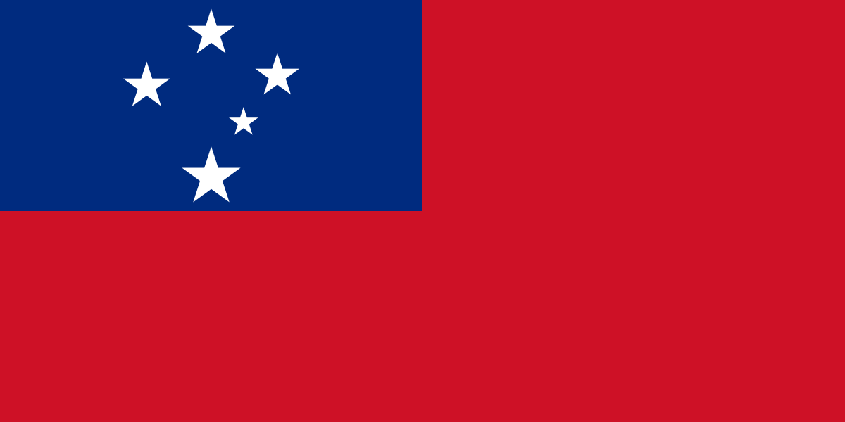
Samoa at a glance
- Capital
- Apia
- Quiz continent
- Oceania
- Languages in reference record
- Samoan and English
- Currency
- Samoan Tala (WST)
- Population
- 219,306 (2025, World Bank)
- Area
- 2,842 km²
- Coastal setting
- Not landlocked
- ISO codes
- WS / WSM
- Internet country suffix
- .ws
- Capital Islands
- Upoli
- Largest island
- Savai’i
- Highest mountain
- Silisili, 1.857 m
- Independence
- 1 January 1962
- Independence celebration
- 1 June
- Ferry service
- Mulifanua–Salelologa
Samoa Flag: Design, Meaning and History
The flag shows a red background and a blue rectangle in the upper left corner. There are five white five-pointed stars in the shape of the Southern Cross. One star is smaller than the rest. Unlike New Zealand, the stars are white and the field does not have a Union Jack.
The Southern Cross refers to the situation in the Southern Hemisphere. Red is associated with courage, blue with freedom and white with purity. The motif was created before state independence and combines an easily recognizable celestial figure with a simple two-color structure. The stars do not represent an island map like Tuvalu or a number of administrative units.
Capital: Apia
Apia is located on the north coast of Upolus. The capital is the political and economic center of the state and an important port. The name refers to an urban space that has grown together with neighboring settlements. Upolu is therefore particularly important for many national functions despite a smaller area compared to Savai’i.
Ferry connections between the main islands start west of Apia near Mulifanua and lead to Salelologa on Savai’i. The state tourism organization describes this connection as an essential access to the larger island. So the capital and ferry port are not the same place. The comparison shows how central facilities can be distributed on an island instead of gathering completely in the capital center.
Practise this capital →Samoa: Geography, History and Culture
The two main islands have volcanic mountains and narrow coastal plains. The Silisili on Savai’i reaches 1,857 meters and is the highest mountain in the country. Lava fields, waterfalls and steep slopes show different consequences of the volcanic relief. The coastal plains offer different settlement possibilities than the harder-to-access mountainous island interior.
Samoan is one of the Polynesian languages. The commonly used term “fa’a Samoa” denotes the Samoan way of life and its social connections, but is not a simple list of immutable qualities of all human beings. Family relationships, village communities and traditional titles are important historical institutions. At the same time, migration, urban development and international connections shape today’s society.
Samoa became independent on 1 January 1962 from the New Zealand-administered UN Trusteeship. Independence celebrations take place on 1 June; public holiday and actual date of independence are therefore to be distinguished. American Samoa is another political area east of it. This separation is just as important when reading maps as the distinction between the capital island of Upolu and the largest island of Savai’i.
Larger island without capital
Savai’i is larger than Upolu and has the highest mountain in Silisili. Apia is still on Upolu.
Constellation in the corner field
Five white stars form the Southern Cross. The depiction distinguishes Samoa from Pacific flags with a British corner motif.
Date and Celebration Different
Independence occurred on January 1, 1962. June 1 is the traditional date of the national independence celebration.
Explore neighbouring and related places
 Australia
 Federated States of Micronesia
 Fiji
 Kiribati
 Marshall Islands
 Nauru
What did you discover?
Sources and image credits
This English article draws on the institutional sources listed below. Figures and memberships retain their stated reference dates.
Source record: 2 November 2026. A translation does not change the reference date of a figure or membership list.
- github.com/factbook/factbook.json/blob/144d6977b2b01ac1cbd220de754c0a005616760b/australia-oceania/ws.json
- data.worldbank.org/indicator/SP.POP.TOTL
- samoa.travel/samoa-travel-advice/taking-the-ferry-to-savaii
- palemene.ws/history-of-the-parliament/
- github.com/mledoze/countries