Russia Flag, Capital and Country Facts
Russia spans large parts of eastern Europe and northern Asia. The largest country in the world connects densely populated western areas with huge forest, tundra and mountain areas. The capital Moscow is located west of the Urals. The white-blue-red flag is geometrically simple, but requires an exact distinction from other Slavic tricolors.
Test your knowledge →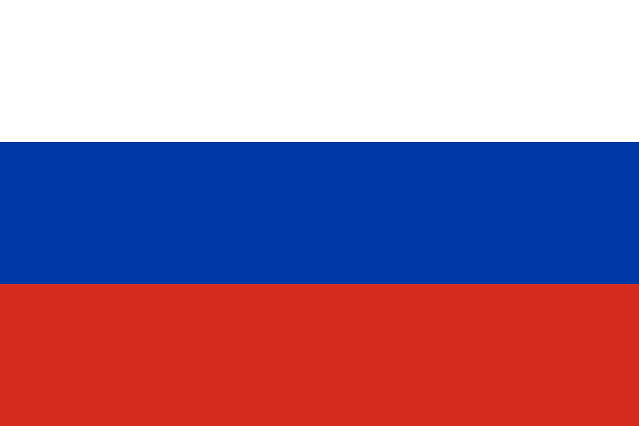
Russia at a glance
- Capital
- Moscow
- Quiz continent
- Europe
- Languages in reference record
- Russian; other languages in the republics and regions
- Currency
- Russian ruble (RUB)
- Population
- 143,513,328 (2025, World Bank)
- Area
- 17,098,242 km²
- Coastal setting
- Not landlocked
- ISO codes
- RU / RUS
- Internet country suffix
- .ru, .su, .рф
- Mountain boundary between continents
- Urals
- Capital river
- Moskva
- Especially deep seas
- Lake Baikal
- Large river in the west
- Volga
- Capital city again Moscow since
- 1918
- National holiday
- 12 June
Russia Flag: Design, Meaning and History
Three horizontal stripes of equal height lie on top of each other in the order of white, blue and red. The national flag shown here does not carry a coat of arms. It differs from the Dutch flag by the inverse position of the red and white stripes. The direction is also important: France uses the same basic colors vertically.
The color arrangement has roots in Russian shipping in the early modern period and later became a national mark of recognition. After the Soviet era, it was resumed in 1991. The Factbook archive expressly points out that the colors are not assigned a uniform official meaning. Popular explanations of individual virtues or landscape elements should therefore not appear as binding symbolism.
Capital: Moscow
Moscow is located on the Moskva in the European part of Russia. The city was for a long time a political and religious center, lost the role of capital temporarily to Saint Petersburg and received it back in 1918. It is thus considerably further west than the center of the huge national territory would suggest.
The Kremlin and Red Square have been UNESCO World Heritage sites since 1990. The Kremlin originally designated a fortified urban complex; the Moscow complex includes, among other things, walls, towers and churches. Its historical function as a center of domination and religion explains the special significance in the cityscape. The capital is also an important transport hub with extensive rail connections.
Practise this capital →Russia: Geography, History and Culture
The Urals often serves as a border between Europe and Asia. The east is followed by vast Siberian landscapes up to the Pacific, while in the south there are other mountains. Tundra, taiga and steppes are different vegetation spaces. The large area therefore means neither a uniform climate nor anywhere similar conditions for agriculture and settlement.
Large streams such as Ob, Yenisei and Lena lead north to the Arctic Ocean. The Volga, on the other hand, flows into the drainless Caspian Sea. This different flow direction characterizes traffic and natural spaces. Lake Baikal in Siberia is the deepest lake on earth and an important freshwater reservoir; it is not to be confused with a marginal sea of the ocean.
Russian is the common state language, and there are also numerous other languages and cultural traditions. The history ranges from principalities to the tsar empire and the Soviet Union to today's federation. For current political or territorial statements, older lexicon data are not sufficient. This page therefore uses the factbook archive with a predominantly 2025 reference for basic geographical contexts and does not take over current government offices or changing political lists of territories from it.
Kremlin and Red Square
The UNESCO ensemble combines fortifications, churches and representative urban spaces. It stands for several historical epochs and not just a single government building.
Rivers in different seas
The Siberian streams and the Volga drain into different large areas. The waterways help to break down the size of the country into manageable landscape systems.
A particularly deep lake
Lake Baikal is located in southern Siberia. Its depth and freshwater reserves make it an independent natural space within the huge land area.
Explore neighbouring and related places
 Azerbaijan
 Belarus
 China
 Estonia
 Finland
 Georgia
What did you discover?
Sources and image credits
This English article draws on the institutional sources listed below. Figures and memberships retain their stated reference dates.
Source record: 2 November 2026. A translation does not change the reference date of a figure or membership list.
- github.com/factbook/factbook.json/blob/144d6977b2b01ac1cbd220de754c0a005616760b/central-asia/rs.json
- data.worldbank.org/indicator/SP.POP.TOTL
- whc.unesco.org/en/list/545
- whc.unesco.org/en/statesparties/ru/
- github.com/mledoze/countries