Belarus Flag, Capital and Country Facts
Belarus lies as a landlocked state between the Baltic Sea and the Black Sea region, without having a sea coast itself. Flat landscapes, forests and large wetlands characterize the country. Minsk is the political and economic centre; historical palaces and the cross-border forest of Białowieża open up completely different sides of its geography and history.
Test your knowledge →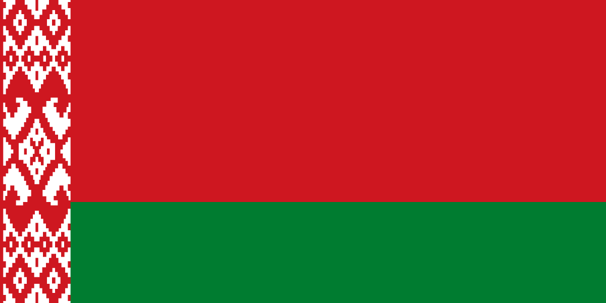
Belarus at a glance
- Capital
- Minsk
- Quiz continent
- Europe
- Languages in reference record
- Belarusian and Russian
- Currency
- Belarusian Ruble (BYN)
- Population
- 9,085,991 (2025, World Bank)
- Area
- 207,600 km²
- Coastal setting
- Landlocked
- ISO codes
- BY / BLR
- Internet country suffix
- .by
- Highest point
- Dziarzhynskaya Hara, 346 m
- Capital river
- Swislat
- Natural heritage
- Forest of Białowieża with Poland
- Lock system
- Mirror
- Residence ensemble
- Nyaswish
- National holiday
- 3 July
Belarus Flag: Design, Meaning and History
The flag shows a wide red stripe above a narrower green stripe. On the mast runs a vertical white band with red geometric ornament. The proportions are important: red takes up about two-thirds of the height, green about one-third; the pattern stands separately on the left edge.
The ornament refers to traditional textile design. In the symbolism explained in the Factbook archive, green is associated with forests and hope, red with historical struggles. The flag is to be distinguished from the white-red-white historical flag also associated with Belarus; the quiz expressly shows the red-green state motif with ornament.
Capital: Minsk
Minsk is located in the interior of the country on the river Swislatsch. As the capital, the city bundles state institutions and important transport connections. Its central location makes it an obvious starting point for spatial orientation: neighbouring countries are located west, north, east and south around the Belarusian inland area.
The city suffered heavy destruction during the Second World War and was then rebuilt on a large scale. This explains the importance of broad streets and younger urban complexes in today's cityscape. Minsk thus stands for a different historical development than the preserved noble residences of Mir and Njaswisch, which preserve individual earlier periods of construction more clearly.
Practise this capital →Belarus: Geography, History and Culture
The relief is predominantly flat to gently corrugated. The highest point, Dzjarschynskaya Hara, reaches only 346 meters. Especially in the south are extensive lowlands and wetlands. However, the low altitude does not mean landscape uniformity: forests, rivers, lakes and moors create different habitats within the lowlands.
Belarus has two official languages, Belarusian and Russian. Linguistic affiliation, everyday language and state recognition are various questions. Historical links with neighbouring regions are also reflected in Polish and Ukrainian linguistic communities as well as in the architecture of earlier noble landscapes. The country can therefore not be described culturally only through the capital.
The forest of Białowieża is a common natural heritage of Belarus and Poland. UNESCO also runs the Mir castle complex and the Radziwiłł complex in Njaswisch. Natural history and building history come together here in different ways: once as a large-scale forest ecosystem, once as preserved evidence of aristocratic rule and landscape design.
Transboundary forest
Białowieża continues on the Polish side. The joint World Heritage status draws attention to a habitat whose ecological connections are older than the current state border; for card learning, it connects Belarus directly with Poland.
Me and Njaswisch
The two UNESCO complexes preserve different parts of the building and residence history. They complement the picture of the greatly renewed Minsk and show why city history and national history cannot always be read on the same visible buildings.
Inland landlocked with many waters
A missing sea coastline does not mean that water would be scenically insignificant. Rivers, lakes and especially the southern wetlands are among the most striking geographical features; they help to place Belarus within the Eastern European lowlands.
Explore neighbouring and related places
 Latvia
 Lithuania
 Poland
 Russia
 Ukraine
What did you discover?
Sources and image credits
This English article draws on the institutional sources listed below. Figures and memberships retain their stated reference dates.
Source record: 2 November 2026. A translation does not change the reference date of a figure or membership list.
- github.com/factbook/factbook.json/blob/144d6977b2b01ac1cbd220de754c0a005616760b/europe/bo.json
- data.worldbank.org/indicator/SP.POP.TOTL
- whc.unesco.org/en/statesparties/by/
- github.com/mledoze/countries