Poland Flag, Capital and Country Facts
Poland lies between the Baltic coast and the mountains in the south. Wide plains, lake landscapes and the large rivers Vistula and Oder divide the country. Warsaw is the capital, Krakow a former royal center. Rebuilt cities, historical trading places and cross-border natural areas show different chapters of Polish history and geography.
Test your knowledge →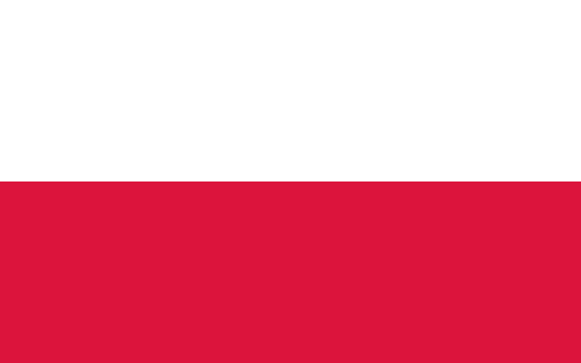
Poland at a glance
- Capital
- Warsaw
- Quiz continent
- Europe
- Languages in reference record
- Polish; recognised minority and regional languages complement the language landscape
- Currency
- Polish Złoty (PLN)
- Population
- 36,435,861 (2025, World Bank)
- Area
- 312,679 km²
- Coastal setting
- Not landlocked
- ISO codes
- PL / POL
- Internet country suffix
- .pl
- Highest point
- Rysy, Polish summit 2,499 m according to archives
- Capital river
- Vistula
- Other important waterways
- Or
- Independence Day
- 11 November
- Historic Royal City
- Cracow
- Transboundary forest
- Białowieża with Belarus
Poland Flag: Design, Meaning and History
The flag consists of two equally high horizontal stripes: above white, below red. The basic shape shown here does not carry a coat of arms. The order is crucial because Indonesia and Monaco use red over white. Even the reversed surfaces therefore change the country assignment, although the same two colors appear.
White and red come from the Polish coat of arms with white eagle on a red background. The simple flag thus condenses an older heraldic tradition into two color areas. The eagle does not have to be visible on the usual national flag to explain the historical color context; coat of arms and simple two-color flag are different versions.
Capital: Warsaw
Warsaw is located on the Vistula in the eastern part of the country. Today’s capital function is to be distinguished from the older significance of Cracow. Both cities are important, but for different historical reasons. The Vistula connects different Polish landscapes and cities on their way from the southern mountains to the Baltic Sea.
The old town of Warsaw was largely destroyed during the Second World War and then reconstructed. UNESCO is paying tribute to this reconstruction effort. The World Heritage Site is therefore not an example of a completely untouched medieval city, but for the targeted recovery of a historical cityscape after extraordinary destruction.
Practise this capital →Poland: Geography, History and Culture
In the north are the Baltic coast and lake landscapes characterized by ice ages. In the middle, larger lowland areas dominate, while in the south Sudeten and Carpathians rise. The Polish summit of the Rysy in the Tatra reaches 2,499 meters according to the Factbook archive. The landscape thus changes from the coastal area to a high-alpine border mountains.
The forest of Białowieża is located on the border with Belarus and belongs to the common UNESCO natural heritage. It stands for a large-scale forest context that crosses state borders. In addition, Poland preserves numerous cultural sites, including Krakow, the Wieliczka salt mine and the old town of Zamość; natural and building history give different approaches to the countryside.
Polish is one of the West Slavic languages. The Złoty serves as the currency, not automatically the euro despite EU membership. Political history spans long periods of changing borders and lost statehood. Independence Day on November 11 commemorates the regaining of state independence in 1918 and is therefore an important dated reference point.
Warsaw as reconstruction
The UNESCO registration of the old town focuses on reconstruction and social effort. Visible historical buildings can thus at the same time be testimonies of the 20th century; age of appearance and age of the preserved building substance are not always identical.
White over red
In this very simple flag, the order carries the crucial information. Poland has the white stripe above. Anyone who remembers this together with the white coat of arms eagle on a red background can combine the colors with their historical origin.
Protecting Białowieża together
The forest continues in Belarus. The cross-border UNESCO entry shows how a natural area connects two states; the political border is important for management, while ecological relations affect the entire forest context.
Explore neighbouring and related places
 Belarus
 Czechia
 Germany
 Lithuania
 Russia
 Slovakia
What did you discover?
Sources and image credits
This English article draws on the institutional sources listed below. Figures and memberships retain their stated reference dates.
Source record: 2 November 2026. A translation does not change the reference date of a figure or membership list.
- github.com/factbook/factbook.json/blob/144d6977b2b01ac1cbd220de754c0a005616760b/europe/pl.json
- data.worldbank.org/indicator/SP.POP.TOTL
- whc.unesco.org/en/statesparties/pl/
- github.com/mledoze/countries